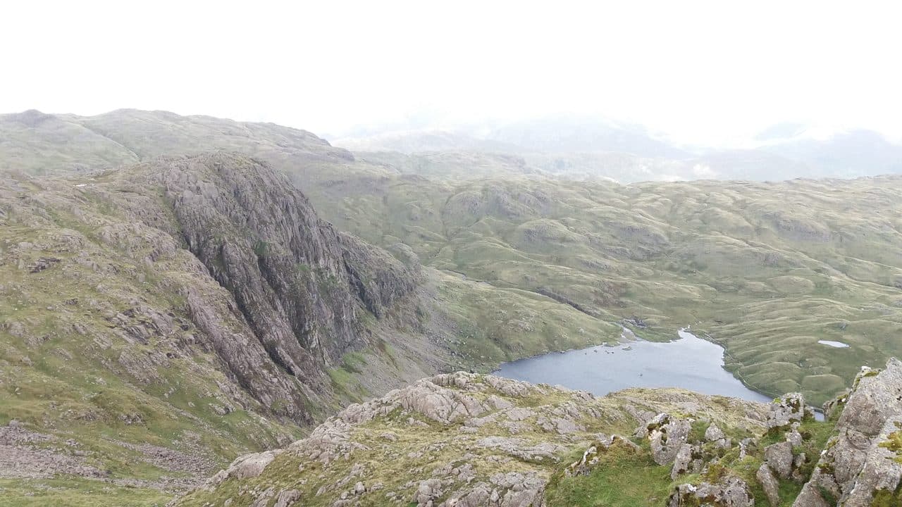
The Langdale Pikes are the row of rock peaks along the north side of Great Langdale: Pike o' Stickle, Loft Crag, Harrison Stickle and Pavey Ark. The usual round adds Thunacar Knott, the grassy top behind them, and bags five Wainwrights in an afternoon's walking. All five are in the Central Fells.
The WalkLakes round from New Dungeon Ghyll is 9.1 km with 869 m of ascent, with a minimum walking time of 3 hours 16 minutes. That is a lot of climbing for the distance, and most people take five hours or more with stops. WalkLakes rates the ground hands on rock, steep and loose in places, and boggy behind the Pikes, where paths come and go. Take a map and compass.
The Langdale Pikes, from Stickle Ghyll
| Rank | Fell | Height | Area | Difficulty |
|---|---|---|---|---|
| 89 | Pavey ArkCentral Fells | 700 m | Central Fells | Moderate |
| 76 | Thunacar KnottCentral Fells | 723 m | Central Fells | Easy |
| 83 | Pike o'StickleCentral Fells | 708 m | Central Fells | Moderate |
| 98 | Loft CragCentral Fells | 682 m | Central Fells | Moderate |
| =69 | Harrison StickleCentral Fells | 736 m | Central Fells | Difficult |
Where to start and park
- The National Trust Stickle Ghyll car park, beside the New Dungeon Ghyll hotel and the Sticklebarn (NY 294 063). It is pay and display and free for National Trust members. The path up Stickle Ghyll starts right behind it.
- The National Trust car park at the Old Dungeon Ghyll, about a kilometre further up the valley, is the start if you plan to come down Mickleden.
Both fill early on fine weekends. The 516 bus runs from Ambleside to Dungeon Ghyll roughly hourly, all year. Wainwrights by bus has the timetable link and more walks from the 516.
Which way round
WalkLakes goes up Stickle Ghyll to Stickle Tarn, climbs Pavey Ark first, then crosses the plateau to Thunacar Knott, Pike o' Stickle and Loft Crag, and finishes over Harrison Stickle before dropping back to the tarn. It is the better direction for three reasons.
- Pavey Ark comes first. Whether you take Jack's Rake or North Rake, you climb it rather than come down it. Don't plan to come down Jack's Rake.
- The boggy middle comes while you are fresh. Harrison Combe, between Thunacar Knott and the Pikes, is where the path is at its faintest.
- Harrison Stickle is the highest of the Pikes at 736 m and the best place to finish, looking straight down to the valley.
The Stickle Ghyll path is stone pitched and crosses the beck twice. WalkLakes uses the footbridge to the east bank on the way up, then large stepping stones back to the west bank. Note where, because you need the same stones on the way down.
Pavey Ark: Jack's Rake or North Rake
Pavey Ark is the big dark cliff behind Stickle Tarn, and there are three ways up the face side.
- Jack's Rake. A Grade 1 scramble that climbs diagonally left across the face in a natural groove. A low wall of rock on the outside makes it feel less exposed than it looks, but it is steep, polished in places and serious when wet. Two people died in falls from it in June 2012, and the BMC advises a helmet. Leave space between you and the party ahead, as stones get knocked down.
- Easy Gully, further east. Steep scree with some boulder moves near the top.
- North Rake. Walk round the east shore of the tarn, follow Bright Beck and climb the cairned gully on the east ridge. WalkLakes calls it steep and rough, with no difficulties. This is the walkers' way.
The summit is bare rock a short way north of where Jack's Rake comes out. Stickle Tarn is the place to fill water bottles; on the tops there are only puddles and the odd stream.
The summits the path skips
Thunacar Knott is the one people miss. The other three Pikes each end with a bit of rock that some walkers skip.
- Thunacar Knott. The path from Pavey Ark towards Harrison Stickle passes it by. About 50 m along that path, bear right onto an intermittent path. There are two tops close together. The southern one is a little higher, but the northern one has the bigger cairn and WalkLakes treats it as the summit, so visit both. In mist, WalkLakes says the only way to find it is a bearing, roughly west north west.
- Pike o' Stickle. The path across Harrison Combe runs to the foot of the summit dome and many people stop there. The top needs a short clamber on good rock. WalkLakes climbs alongside a gully and warns that the steeper ramps can end with a precarious move.
- Loft Crag. The last 20 or 30 metres above the col is an easy scramble with plenty of variations to a small rocky knob. It juts furthest over the valley of the three Pikes, so it has the best view down Great Langdale.
Thorn Crag, the small top between Loft Crag and Harrison Stickle, is on the WalkLakes route but isn't a Wainwright.
The tricky bits
- The Stickle Stone Shoot. The gully below Pike o' Stickle's summit is badly eroded and is no longer recommended up or down.
- Harrison Combe. WalkLakes calls it a morass of soft, squidgy bog. Paths are faint, and in cloud it is easy to wander.
- The crags. Harrison Stickle and Loft Crag drop about 600 m to the valley on their south and east sides. In poor visibility keep well back from the edge, and come down a way you know.
- Dungeon Ghyll. The ravine below Harrison Stickle is not a through route for walkers.
- Dogs. WalkLakes rates the ground around Pike o' Stickle potentially dangerous for a dog, and there is a stile with no dog gap on the west bank of Stickle Ghyll.
Ways down
- From the plateau, back to Stickle Tarn and down Stickle Ghyll. This is the WalkLakes return.
- From Harrison Stickle, down the south side by Pike How straight to New Dungeon Ghyll.
- From Loft Crag, down the path that slants between Thorn Crag and Gimmer Crag and past Dungeon Ghyll Force to the car park.
- From Pike o' Stickle, north west over Martcrag Moor to Stake Pass and the Cumbria Way down Mickleden to the Old Dungeon Ghyll. It is longer and gentler, but small sections of it are boggy and hard to follow. The Walk Up Scafell Pike guide comes back this way, 12.1 km with 777 m in about four hours.
In winter
The Stickle Ghyll path is stone pitched and very slippery when iced, so on short days allow for coming down it in failing light. In snow and ice, Jack's Rake stops being a walkers' scramble and becomes a winter climb, and North Rake can fill with hard snow. The summit rocks of all three Pikes become serious with ice on them. Check the Mountain Weather Information Service (MWIS) forecast and the National Park's fell top report, and read the winter Wainwrights guide before you go.
Adding more fells
- High Raise, 762 m, the highest point of the Central Fells, is about 1.5 km north of Thunacar Knott across open moor.
- Sergeant Man, 736 m, is a small rocky top just south east of High Raise.
- Blea Rigg, 556 m, is on the long ridge running south east from Sergeant Man. Come back over it to Stickle Tarn for an eight-fell day, or follow the ridge on over Loughrigg Fell into Ambleside on the WalkLakes linear walk and take the bus back.
Fells to add from the plateau

How it fits a Wainwright round
Five Wainwrights from one car park is a good early day on a round, and Great Langdale has plenty more. Bowfell, Crinkle Crags and Pike o' Blisco start from the Old Dungeon Ghyll, and Lingmoor Fell from Elterwater. Wainwrights from Ambleside covers the bus and the valley, and Wainwrights from Grasmere has the walk over from Grasmere.
If Jack's Rake is the bit you enjoy, Helvellyn by Striding Edge is the other Grade 1 classic. For a longer round with no scrambling, try the Fairfield Horseshoe. Carry a map and compass. Upfell is a free iPhone app that keeps your list of bagged fells for you.
Browse all 214 Wainwrights or every guide.