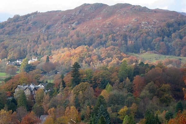
You can climb a lot of Wainwrights without a car. Stagecoach buses reach Borrowdale, Buttermere, Langdale, Coniston, Patterdale and the tops of two passes. The lists below name 78 Wainwrights you can walk from a stop, and they are far from the only ones. The far west is the hard part: no route in the Stagecoach Lakes guide reaches Wasdale or Ennerdale.
Everything below comes from the Stagecoach Lakes by Bus guide for summer 2026, which runs from 23 March to 1 November, and the winter 2025 to 2026 guide before it. Routes and numbers change from year to year. Check before you travel on stagecoachbus.com/thelakes or the Stagecoach Bus app, which also shows buses live.
Why leave the car at home
A car brings you back to where you started. A bus lets you start in one valley and finish in the next, so you walk a ridge once instead of going up and back down the same path. The best walks in this guide only work that way.
Two routes also start you high. The Honister Rambler stops at the slate mine at the top of Honister Pass, and the 508 stops at the Kirkstone Pass Inn. From there Red Screes is 2.5 km there and back with 336 m of climbing, according to WalkLakes.
It is cheap, too. In summer 2026 a single fare was capped at £3, and a North West Explorer ticket gave a day of unlimited travel for £12.50. Bus and Boat tickets add a boat ride on Coniston, Derwentwater, Ullswater or Windermere to a day's bus travel.
The two railway stations
- Windermere is the end of the Lakes Line, a Northern branch from Oxenholme Lake District on the West Coast Main Line, calling at Kendal, Burneside and Staveley. The 555, 599, 505 and 508 all call at the station.
- Penrith North Lakes is on the West Coast Main Line itself, served by Avanti West Coast and TransPennine Express. The 508 and 509 to Ullswater and the X4 and X5 to Keswick leave from there.
Keswick has no station, so arrive at Penrith and take the X4 or X5, or at Windermere and take the 555.
The key routes, and what they unlock
555: Windermere, Grasmere and Keswick, all year
The 555 runs from Lancaster and Kendal through Windermere, Ambleside, Rydal, Grasmere and past Thirlmere to Keswick. Get off at Rydal Church for the Fairfield Horseshoe, at Grasmere for Helm Crag, Silver How and Seat Sandal, and at the Kings Head at Thirlspot for Helvellyn from the west. The open-top 599 covers the same road between Bowness and Grasmere.
From the 555
| Rank | Fell | Height | Area | Difficulty |
|---|---|---|---|---|
| 211 | Loughrigg FellCentral Fells | 335 m | Central Fells | Moderate |
| 190 | Nab ScarEastern Fells | 450 m | Eastern Fells | Easy |
| 127 | Heron PikeEastern Fells | 612 m | Eastern Fells | Moderate |
| 13 | FairfieldEastern Fells | 873 m | Eastern Fells | Moderate |
| 54 | Great RiggEastern Fells | 766 m | Eastern Fells | Easy |
| 174 | Stone ArthurEastern Fells | 504 m | Eastern Fells | Easy |
| 201 | Helm CragCentral Fells | 405 m | Central Fells | Moderate |
| 202 | Silver HowCentral Fells | 395 m | Central Fells | Moderate |
| =67 | Seat SandalEastern Fells | 737 m | Eastern Fells | Moderate |
| 3 | HelvellynEastern Fells | 950 m | Eastern Fells | Difficult |
| 16 | White SideEastern Fells | 863 m | Eastern Fells | Moderate |
| 12 | RaiseEastern Fells | 883 m | Eastern Fells | Moderate |
78 Borrowdale Bus, all year
The 78 runs from Keswick to Grange, Rosthwaite and Seatoller, about every half hour in summer and hourly in winter. Grange is the foot of Maiden Moor and High Spy. From Rosthwaite, the WalkLakes Castle Crag walk is 4.5 km with 214 m of climbing. Stonethwaite, a short walk from Rosthwaite, is the start for Eagle Crag and Sergeant's Crag. See Wainwrights from Borrowdale.
From the 78
| Rank | Fell | Height | Area | Difficulty |
|---|---|---|---|---|
| 214 | Castle CragNorth Western Fells | 290 m | North Western Fells | Moderate |
| 199 | Grange Fell (Brund Fell)Central Fells | 417 m | Central Fells | Easy |
| 191 | Great CragCentral Fells | 449 m | Central Fells | Moderate |
| 139 | Maiden MoorNorth Western Fells | 575 m | North Western Fells | Moderate |
| 113 | High SpyNorth Western Fells | 653 m | North Western Fells | Moderate |
| 160 | Eagle CragCentral Fells | 525 m | Central Fells | Difficult |
| 141 | Sergeant's CragCentral Fells | 571 m | Central Fells | Moderate |
| =149 | Rosthwaite Fell (Bessyboot)Southern Fells | 551 m | Southern Fells | Moderate |
| 45 | GlaramaraSouthern Fells | 783 m | Southern Fells | Difficult |
| 117 | Base BrownWestern Fells | 646 m | Western Fells | Moderate |
77 and 77A Honister Rambler, seasonal
The Honister Rambler is a loop from Keswick. The 77A goes via Catbells, Seatoller, the Honister Slate Mine and Buttermere, then back via Lorton, Whinlatter and Braithwaite; the 77 goes the other way. From Honister, Dale Head, Fleetwith Pike, Grey Knotts and Brandreth are all within about 400 m of climbing. Buttermere has High Stile, Red Pike and Haystacks, and Lanthwaite Green is the start for Grasmoor and Whiteside. It does not run in winter. See Wainwrights from Buttermere.
From the Honister Rambler
| Rank | Fell | Height | Area | Difficulty |
|---|---|---|---|---|
| 189 | CatbellsNorth Western Fells | 451 m | North Western Fells | Easy |
| 63 | Dale HeadNorth Western Fells | 753 m | North Western Fells | Moderate |
| 116 | Fleetwith PikeWestern Fells | 649 m | Western Fells | Difficult |
| =91 | Grey KnottsWestern Fells | 697 m | Western Fells | Moderate |
| =79 | BrandrethWestern Fells | 715 m | Western Fells | Moderate |
| 35 | Green GableWestern Fells | 801 m | Western Fells | Moderate |
| 131 | HaystacksWestern Fells | 597 m | Western Fells | Moderate |
| 65 | High CragWestern Fells | 744 m | Western Fells | Difficult |
| 30 | High StileWestern Fells | 806 m | Western Fells | Difficult |
| 62 | Red Pike [Buttermere]Western Fells | 755 m | Western Fells | Difficult |
| =67 | RobinsonNorth Western Fells | 737 m | North Western Fells | Moderate |
| 106 | Whiteless PikeNorth Western Fells | 660 m | North Western Fells | Moderate |
| 210 | Rannerdale KnottsNorth Western Fells | 355 m | North Western Fells | Moderate |
| 20 | GrasmoorNorth Western Fells | 852 m | North Western Fells | Difficult |
| 84 | Whiteside (west top)North Western Fells | 707 m | North Western Fells | Moderate |
| 165 | Whinlatter (Brown How)North Western Fells | 517 m | North Western Fells | Moderate |
| 148 | Lord's SeatNorth Western Fells | 552 m | North Western Fells | Moderate |
X4 and X5: Penrith to Keswick and Cockermouth, all year
The X4 and X5 run along the A66. Both stop at Threlkeld for Blencathra and Clough Head. The X5 also calls at Braithwaite, the start of the Coledale Horseshoe, and at Thornthwaite under Barf. See Wainwrights from Braithwaite.
From the X4 and X5
| Rank | Fell | Height | Area | Difficulty |
|---|---|---|---|---|
| 14 | BlencathraNorthern Fells | 868 m | Northern Fells | Difficult |
| =74 | Clough HeadEastern Fells | 726 m | Eastern Fells | Easy |
| 40 | Grisedale PikeNorth Western Fells | 791 m | North Western Fells | Difficult |
| 142 | OutersideNorth Western Fells | 568 m | North Western Fells | Moderate |
| 187 | BarrowNorth Western Fells | 455 m | North Western Fells | Easy |
| =119 | Causey PikeNorth Western Fells | 637 m | North Western Fells | Moderate |
| 185 | BarfNorth Western Fells | 469 m | North Western Fells | Moderate |
| 148 | Lord's SeatNorth Western Fells | 552 m | North Western Fells | Moderate |
508, 509 and the Ullswater Steamers
The 508 runs from Penrith station to Pooley Bridge, Aira Force, Glenridding and Patterdale, and in summer on over Kirkstone Pass to Troutbeck, Bowness and Windermere. The 509, new for 2026 and summer only, links Keswick with Glenridding and Patterdale by Threlkeld and Dockray. Glenridding is the start for Helvellyn from the east, Patterdale for Place Fell and St Sunday Crag, and the Kirkstone Pass Inn for Red Screes.
Ullswater Steamers sail between Glenridding, Howtown and Pooley Bridge. Howtown pier is the start of the lakeshore path back to Glenridding, and Hallin Fell is just above it. See Wainwrights from Glenridding and Patterdale and Wainwrights from Pooley Bridge.
From the 508, 509 and the steamer
| Rank | Fell | Height | Area | Difficulty |
|---|---|---|---|---|
| 193 | Glenridding DoddEastern Fells | 442 m | Eastern Fells | Moderate |
| 99 | Sheffield PikeEastern Fells | 676 m | Eastern Fells | Moderate |
| 10 | CatstycamEastern Fells | 890 m | Eastern Fells | Moderate |
| 3 | HelvellynEastern Fells | 950 m | Eastern Fells | Difficult |
| 108 | Place FellFar Eastern Fells | 657 m | Far Eastern Fells | Moderate |
| =22 | Saint Sunday CragEastern Fells | 841 m | Eastern Fells | Moderate |
| 124 | BirksEastern Fells | 622 m | Eastern Fells | Easy |
| 194 | Arnison CragEastern Fells | 433 m | Eastern Fells | Easy |
| 143 | Angletarn PikesFar Eastern Fells | 567 m | Far Eastern Fells | Moderate |
| =136 | Hartsop above HowEastern Fells | 581 m | Eastern Fells | Easy |
| 125 | Hartsop DoddFar Eastern Fells | 618 m | Far Eastern Fells | Moderate |
| =111 | Middle DoddEastern Fells | 654 m | Eastern Fells | Moderate |
| 49 | Red ScreesEastern Fells | 776 m | Eastern Fells | Moderate |
| =55 | Caudale Moor (Stony Cove Pike)Far Eastern Fells | 763 m | Far Eastern Fells | Moderate |
| 203 | Hallin FellFar Eastern Fells | 388 m | Far Eastern Fells | Easy |
| 181 | Gowbarrow FellEastern Fells | 481 m | Eastern Fells | Easy |
516: Ambleside to Great Langdale, all year
The 516 runs from Ambleside to Skelwith Bridge, Elterwater and Dungeon Ghyll. Dungeon Ghyll is the start for the Langdale Pikes, Bowfell, Crinkle Crags and Pike o' Blisco, and Elterwater for Lingmoor Fell. See Wainwrights from Ambleside.
From the 516
| Rank | Fell | Height | Area | Difficulty |
|---|---|---|---|---|
| =69 | Harrison StickleCentral Fells | 736 m | Central Fells | Difficult |
| 89 | Pavey ArkCentral Fells | 700 m | Central Fells | Moderate |
| 98 | Loft CragCentral Fells | 682 m | Central Fells | Moderate |
| 83 | Pike o'StickleCentral Fells | 708 m | Central Fells | Moderate |
| 76 | Thunacar KnottCentral Fells | 723 m | Central Fells | Easy |
| =145 | Blea RiggCentral Fells | 556 m | Central Fells | Moderate |
| 6 | BowfellSouthern Fells | 903 m | Southern Fells | Difficult |
| =17 | Crinkle Crags (Long Top)Southern Fells | 859 m | Southern Fells | Difficult |
| 86 | Pike o'BliscoSouthern Fells | 705 m | Southern Fells | Difficult |
| 184 | Lingmoor FellSouthern Fells | 470 m | Southern Fells | Easy |
505: Windermere to Coniston, all year
The 505 runs from Windermere station and Ambleside through Hawkshead to Coniston. From the village you can reach the whole Coniston range. See Wainwrights from Coniston.
From the 505
| Rank | Fell | Height | Area | Difficulty |
|---|---|---|---|---|
| =31 | Coniston Old ManSouthern Fells | 802 m | Southern Fells | Moderate |
| 48 | Dow CragSouthern Fells | 778 m | Southern Fells | Moderate |
| 37 | Brim FellSouthern Fells | 796 m | Southern Fells | Moderate |
| =31 | Swirl HowSouthern Fells | 802 m | Southern Fells | Moderate |
| =42 | Great CarrsSouthern Fells | 785 m | Southern Fells | Moderate |
| =55 | WetherlamSouthern Fells | 763 m | Southern Fells | Moderate |
One-way walks between two bus stops
These are the walks a car makes awkward. Carry the timetable for the return bus and know when the last one leaves.
- Buttermere to Keswick. WalkLakes has you park in Keswick and take the first bus over Honister to Buttermere, then walk home over Robinson, Hindscarth, Dale Head, High Spy, Maiden Moor and Catbells. That is 20.6 km with 1,261 m of ascent, a minimum of 6 hours 14 minutes. For a shorter day, stop after Dale Head, Hindscarth and Robinson, or start at Honister and finish in Buttermere.
- Glenridding to Thirlspot. One walker's car-free round took the 508 to Glenridding, crossed Glenridding Dodd, Sheffield Pike, Raise and White Side, and came down to the 555 at Thirlspot. That is about 6.5 miles and 3,100 feet of climbing.
- Dungeon Ghyll to Ambleside. Take the 516 up the valley, climb Harrison Stickle and Thunacar Knott, then follow the long spur south east over Blea Rigg and Loughrigg Fell into Ambleside, as described in this WalkLakes linear walk.
- Grasmere to Patterdale. This is a stage of the Coast to Coast. From Grisedale Hause, Wainwright offered three ways down: over Helvellyn, over St Sunday Crag, or along Grisedale. In summer the 508 goes back over Kirkstone to Windermere.
- Rosthwaite to Grasmere. The Coast to Coast stage before, from the 78 at Rosthwaite by Stonethwaite to Greenup Edge, then along the Helm Crag ridge to the 555 in Grasmere.
- Catbells to Grange. Get off the 77A at the Catbells stop, walk the ridge south over Maiden Moor and High Spy, drop to Grange and catch the 78 back. The Keswick guide has the details, and the Newlands Horseshoe guide covers the full round.
Fells on the one-way walks
 Robinson737 mNorth Western Fells
 Hindscarth727 mNorth Western Fells
 Dale Head753 mNorth Western Fells
 Glenridding Dodd442 mEastern Fells
 Sheffield Pike676 mEastern Fells
 Raise883 mEastern Fells
 White Side863 mEastern Fells
 Harrison Stickle736 mCentral Fells
 Thunacar Knott723 mCentral Fells
 Blea Rigg556 mCentral Fells
 Loughrigg Fell335 mCentral Fells
 Saint Sunday Crag841 mEastern Fells
 Helvellyn950 mEastern Fells
 Helm Crag405 mCentral Fells
 Catbells451 mNorth Western Fells
 Maiden Moor575 mNorth Western Fells
 High Spy653 mNorth Western Fells
Seasons and the small print
- Timetable seasons. The summer 2026 timetable runs from 23 March to 1 November. Winter 2025 to 2026 ran from 3 November to 22 March.
- Summer only: the 77/77A Honister Rambler, the 509 and the 508 over Kirkstone Pass. In winter the 508 stops at Patterdale. Some Rambler journeys ran only at weekends and on public holidays from 2 May to 31 August 2026, and some 509 journeys only at weekends and in school holidays.
- All year, but less often in winter: the 78, 505, 516, 555, 599 and X4/X5 all appeared in the winter 2025 to 2026 guide. The 78 drops from half hourly to hourly.
- Road closures. A landslip shut the A592 below Kirkstone Pass from November 2025 until 17 July 2026, and the 508 could not cross the pass while it was shut.
- No bus at all. Wasdale, Ennerdale and Kentmere have no route in the Stagecoach guide. For the Kentmere Horseshoe, Staveley has a station and a 555 stop at the foot of the valley. The Mosedale Horseshoe and the rest of Wainwrights from Wasdale mean a long walk in or a night at Wasdale Head.
The last bus matters more than the first. Walking out of a valley at dusk after the last bus has gone is a long evening. Check the Mountain Weather Information Service (MWIS) before you set off, carry a map and compass, and plan a way down to a stop that runs later if the day goes slowly.
If you are ticking them off, Upfell is a free iPhone app that keeps the list, or print the Wainwrights checklist. For bases with the best buses, start with Keswick, Windermere or Grasmere.