North Western Fells · Book 6
Grisedale Pike
Grisedale Pike is a Wainwright, one of the 214 Lake District fells in Alfred Wainwright’s Pictorial Guides. At 791 m (2,595 ft) it is the 40th highest of the 214 and the 3rd highest in the North Western Fells.
- Height
- 791 m
- 2,595 ft
- Rank
- 40
- of 214
- In area
- 3
- of 29
- Difficulty
- Difficult
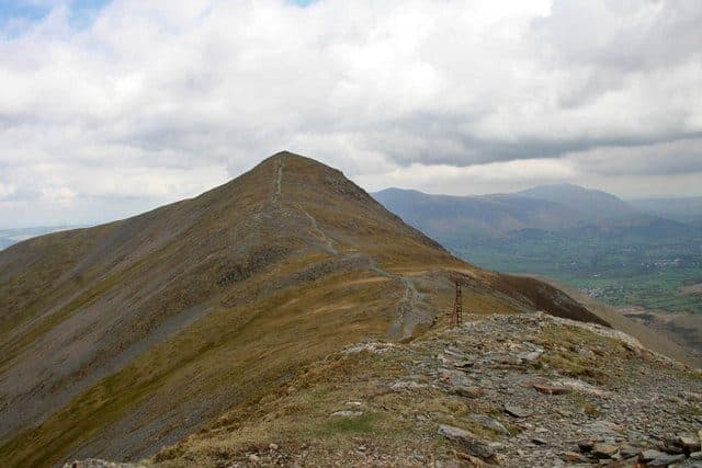
Photo: Helen Wilkinson via Geograph, CC BY-SA 2.0
About Grisedale Pike
A shapely, ever‑popular North Western skyline with a true summit feel. The approach ridge sharpens nicely and the views over Coledale and the sea are huge. Best on a clear, breezy day.
Grisedale Pike rises straight out of Braithwaite, and its east ridge is the way most people go. Start from the small parking area in an old quarry on the Whinlatter road just above the village, opposite the Hope Memorial Camp. The spaces go quickly, but there is more parking in the village, and at busy times the village school has opened its grounds to walkers for a small fee. The path climbs steeply through bracken to Kinn, above the Heavy Sides plantation, then follows a long ridge of grass and heather over Sleet How.
From the Whinlatter side you can start near the top of the pass and come up either the north ridge over Hobcarton End or the north-east ridge beside a tumbledown wall. The Honister Rambler bus (77) is listed as calling at Whinlatter Forest in season.
The first half of the Braithwaite ridge is easy walking. Beyond Sleet How it narrows, and the last pull is a rough clamber up loose stones and rock steps. You will use your hands now and then, but there is no real exposure.
The summit is small, with steep ground on most sides, and it feels like the top of a proper peak. On a clear day you can see the hills of southern Scotland and the Isle of Man, and people have reported seeing Slieve Donard in Northern Ireland. Skiddaw and the Dodds are close at hand to the east.
Most people continue west over Hobcarton Crag to Hopegill Head and drop into Coledale on engineered zigzags. That brings you out at Force Crag Mine, which closed in 1990 after a major collapse. It was the last working metal mine in the Lake District, producing lead, zinc and barytes. The old mine road leads back to Braithwaite.
In winter
The rocky steps at the top of Sleet How, just below the summit, ice first, and the whole east ridge takes the full force of a westerly. The drop from the summit towards Hobcarton Crag is steep, so keep well back from the northern edge in snow.
- Ridge Walk
- Great Views
- Popular
- Potentially Dangerous
- Dog Friendly
Sources: Wikipedia: Grisedale Pike, Walk Lakes: Grisedale Pike and Hopegill Head. Updated .
Summit
- OS grid ref
- NY 198 225
- Latitude
- 54.59173° N
- Longitude
- 3.24205° W
Walking up Grisedale Pike
The nearest car park on foot is Revelin Moss, 2.2 km (1.4 miles) from the summit along mapped paths. Directions to the car park
Route from Revelin Moss
- Distance
- 2.2 km
- 1.4 miles, one way
- Ascent
- 482 m
- Total climb to the summit
- Time up
- 1 h 12 min
- Allow 1 to 2 hours
Times use Naismith’s rule, 5 km/h on the flat plus extra time for the climb, with Langmuir’s corrections. It’s a rule of thumb for the way up only, so add stops, weather and the walk back down.
The route follows paths mapped by OpenStreetMap contributors and isn’t a guided line. Check the mountain forecast before you go and carry a map and compass.
Grisedale Pike questions
Is Grisedale Pike a Wainwright?
How high is Grisedale Pike?
Where do you park for Grisedale Pike?
How long does it take to climb Grisedale Pike?
How hard is Grisedale Pike?
Which Wainwrights are near Grisedale Pike?
What is the grid reference for the summit of Grisedale Pike?
Often walked with Grisedale Pike
Fells people usually take in on the same day.
Grisedale Pike in our guides
Wainwrights near Grisedale Pike
Straight-line distance and direction from the summit.
 Hopegill Head770 m1.3 km W
 Outerside568 m1.7 km SE
 Scar Crags672 m2.1 km SE
 Eel Crag (Crag Hill)839 m2.3 km S
 Sail773 m2.3 km S
 Causey Pike637 m2.6 km SE
More in the North Western Fells
- Grasmoor852 m
- Eel Crag (Crag Hill)839 m
- Wandope774 m
- Sail773 m
- Hopegill Head770 m
- Dale Head753 m
- Robinson737 m
- Hindscarth727 m
- Whiteside (west top)707 m
- Scar Crags672 m
- Whiteless Pike660 m
- High Spy653 m
- Causey Pike637 m
- Ard Crags581 m
- Maiden Moor575 m
- Outerside568 m
- Knott Rigg556 m
- Lord's Seat552 m
- Whinlatter (Brown How)517 m
- Broom Fell511 m
- Barf469 m
- Barrow455 m
- Graystones452 m
- Catbells451 m
- Ling Fell373 m
- Sale Fell359 m
- Rannerdale Knotts355 m
- Castle Crag290 m
Bag Grisedale Pike with Upfell
Reach the summit and capture Grisedale Pike, even with no signal. It goes on your round of the 214 with its own patch.
Coming soon to theApp Store