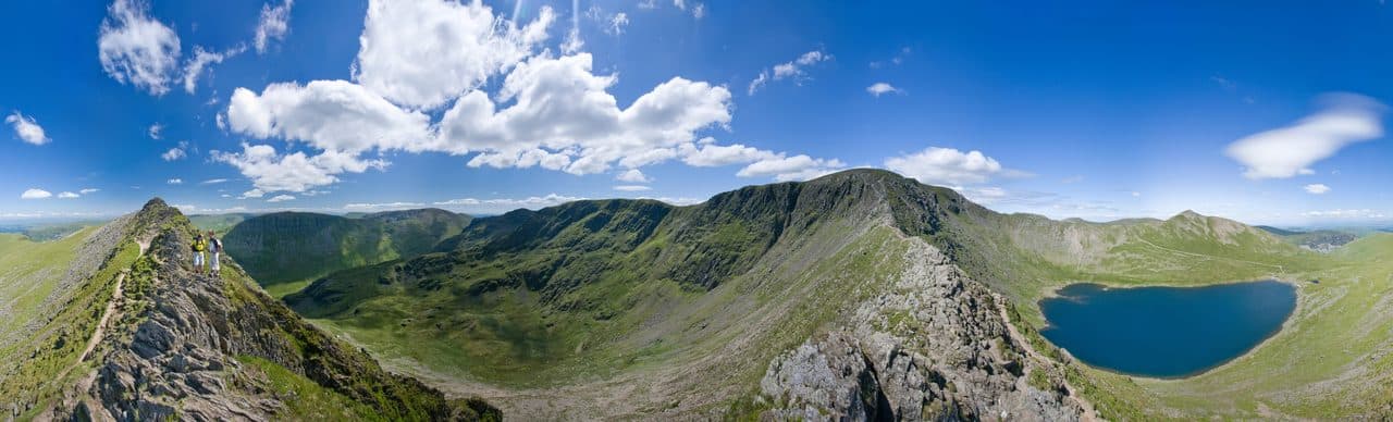
The best Wainwright ridge walks are the horseshoes: rounds that climb one arm of a valley, follow the skyline around its head and come down the other side. The Fairfield Horseshoe above Ambleside, the Kentmere Horseshoe, the Coledale Horseshoe above Braithwaite, the Newlands round and the Mosedale Horseshoe from Wasdale Head each bag a handful of fells in a day. Shorter ridges, such as Longside Edge above Bassenthwaite Lake and the High Stile ridge above Buttermere, give you a skyline walk in half a day.
The fells below make up the Ridge Walk collection in the Upfell app.
Wainwrights on the best ridges
| Rank | Fell | Height | Area | Difficulty |
|---|---|---|---|---|
| 3 | HelvellynEastern Fells | 950 m | Eastern Fells | Difficult |
| 4 | SkiddawNorthern Fells | 931 m | Northern Fells | Moderate |
| 6 | BowfellSouthern Fells | 903 m | Southern Fells | Difficult |
| 9 | Nethermost PikeEastern Fells | 891 m | Eastern Fells | Moderate |
| 12 | RaiseEastern Fells | 883 m | Eastern Fells | Moderate |
| 13 | FairfieldEastern Fells | 873 m | Eastern Fells | Moderate |
| 14 | BlencathraNorthern Fells | 868 m | Northern Fells | Difficult |
| 16 | White SideEastern Fells | 863 m | Eastern Fells | Moderate |
| =17 | Crinkle Crags (Long Top)Southern Fells | 859 m | Southern Fells | Difficult |
| =22 | Saint Sunday CragEastern Fells | 841 m | Eastern Fells | Moderate |
| 27 | Hart CragEastern Fells | 822 m | Eastern Fells | Moderate |
| 30 | High StileWestern Fells | 806 m | Western Fells | Difficult |
| =31 | Kirk FellWestern Fells | 802 m | Western Fells | Difficult |
| =31 | Swirl HowSouthern Fells | 802 m | Southern Fells | Moderate |
| =38 | Rampsgill HeadFar Eastern Fells | 792 m | Far Eastern Fells | Easy |
| 40 | Grisedale PikeNorth Western Fells | 791 m | North Western Fells | Difficult |
| 41 | Watson's DoddEastern Fells | 789 m | Eastern Fells | Moderate |
| =42 | Allen CragsSouthern Fells | 785 m | Southern Fells | Difficult |
| =42 | Great CarrsSouthern Fells | 785 m | Southern Fells | Moderate |
| 44 | Thornthwaite CragFar Eastern Fells | 784 m | Far Eastern Fells | Moderate |
| 45 | GlaramaraSouthern Fells | 783 m | Southern Fells | Difficult |
| 47 | Harter Fell [Mardale]Far Eastern Fells | 779 m | Far Eastern Fells | Moderate |
| 49 | Red ScreesEastern Fells | 776 m | Eastern Fells | Moderate |
| 53 | Hopegill HeadNorth Western Fells | 770 m | North Western Fells | Moderate |
| =55 | Caudale Moor (Stony Cove Pike)Far Eastern Fells | 763 m | Far Eastern Fells | Moderate |
| 60 | Ill BellFar Eastern Fells | 757 m | Far Eastern Fells | Moderate |
| 62 | Red Pike [Buttermere]Western Fells | 755 m | Western Fells | Difficult |
| =67 | RobinsonNorth Western Fells | 737 m | North Western Fells | Moderate |
| 71 | Long SideNorthern Fells | 734 m | Northern Fells | Moderate |
| 73 | HindscarthNorth Western Fells | 727 m | North Western Fells | Moderate |
| 77 | FroswickFar Eastern Fells | 720 m | Far Eastern Fells | Moderate |
| 84 | Whiteside (west top)North Western Fells | 707 m | North Western Fells | Moderate |
| 85 | YokeFar Eastern Fells | 706 m | Far Eastern Fells | Moderate |
| 90 | Gray CragFar Eastern Fells | 699 m | Far Eastern Fells | Moderate |
| =91 | Caw FellWestern Fells | 697 m | Western Fells | Moderate |
| =95 | Ullock PikeNorthern Fells | 690 m | Northern Fells | Moderate |
| 97 | Bannerdale CragsNorthern Fells | 683 m | Northern Fells | Moderate |
| =100 | BakestallNorthern Fells | 673 m | Northern Fells | Moderate |
| =100 | Wether HillFar Eastern Fells | 673 m | Far Eastern Fells | Easy |
| 106 | Whiteless PikeNorth Western Fells | 660 m | North Western Fells | Moderate |
| 110 | Selside PikeFar Eastern Fells | 655 m | Far Eastern Fells | Easy |
| 113 | High SpyNorth Western Fells | 653 m | North Western Fells | Moderate |
| =119 | Causey PikeNorth Western Fells | 637 m | North Western Fells | Moderate |
| 123 | YewbarrowWestern Fells | 627 m | Western Fells | Difficult |
| 132 | Bleaberry FellCentral Fells | 590 m | Central Fells | Moderate |
| =136 | Hartsop above HowEastern Fells | 581 m | Eastern Fells | Easy |
| 140 | Blake FellWestern Fells | 573 m | Western Fells | Moderate |
| 142 | OutersideNorth Western Fells | 568 m | North Western Fells | Moderate |
| 163 | Souther FellNorthern Fells | 522 m | Northern Fells | Easy |
| 166 | SallowsFar Eastern Fells | 516 m | Far Eastern Fells | Easy |
| 174 | Stone ArthurEastern Fells | 504 m | Eastern Fells | Easy |
| 178 | Wansfell (Baystones)Far Eastern Fells | 487 m | Far Eastern Fells | Easy |
| =179 | Sour HowesFar Eastern Fells | 483 m | Far Eastern Fells | Easy |
| =182 | Burnbank FellWestern Fells | 475 m | Western Fells | Easy |
| 184 | Lingmoor FellSouthern Fells | 470 m | Southern Fells | Easy |
| 187 | BarrowNorth Western Fells | 455 m | North Western Fells | Easy |
| 189 | CatbellsNorth Western Fells | 451 m | North Western Fells | Easy |
| 195 | Steel Knotts (Pikeawassa)Far Eastern Fells | 432 m | Far Eastern Fells | Easy |
| 198 | Gibson KnottCentral Fells | 420 m | Central Fells | Easy |
| 201 | Helm CragCentral Fells | 405 m | Central Fells | Moderate |
| 207 | Troutbeck TongueFar Eastern Fells | 364 m | Far Eastern Fells | Moderate |
| 209 | High RiggCentral Fells | 357 m | Central Fells | Moderate |
The five great horseshoes
Fairfield Horseshoe
The classic first horseshoe. It starts from the Rydal Road car park in Ambleside, goes up Nab Scar above Rydal and over Heron Pike and Great Rigg to Fairfield. It comes back over Hart Crag, Dove Crag, High Pike and Low Pike, following a stone wall for much of the way. WalkLakes gives 16.4 km and 1,080 m of ascent over eight Wainwrights. The top of Fairfield is confusing in mist, and WalkLakes says you will need a compass bearing to leave it in the right direction. The full route is in the Fairfield Horseshoe guide.
Kentmere Horseshoe
A long round of the Far Eastern Fells. From Kentmere village the WalkLakes round is 20.7 km with 1,085 m of ascent, and it takes in eight Wainwrights, including Yoke, Ill Bell, Froswick, Thornthwaite Crag and Harter Fell. Thornthwaite Beacon, the summit cairn on Thornthwaite Crag, is a stone column about 4.3 m high and the obvious lunch stop. Parking in Kentmere is a spot for fewer than six cars beside the village hall, so get there early. The only escape in bad weather is at Nan Bield Pass. See the Kentmere Horseshoe guide.
Coledale Horseshoe
From Braithwaite, the full round goes over Grisedale Pike, Hopegill Head, Crag Hill, Sail and Outerside, 15 km with 1,178 m of ascent. Hopegill Head's summit is a small rocky point on the edge of Hobcarton Crag, so stay on the main path where the crags turn sheer. The Coledale Horseshoe guide has the details.
Newlands Horseshoe
The Newlands fells ring the valley west of Derwentwater. The half horseshoe from Hawse End goes over Catbells and Maiden Moor to High Spy, then drops to Dalehead Tarn and comes back down beside Newlands Beck, 16 km with 750 m of ascent. On the other side of the valley, WalkLakes' Scope horseshoe from Little Town climbs Robinson and comes down the narrow, knotted ridge of Hindscarth, 11.3 km with 795 m. The full round links the two over Dale Head; see the Newlands Horseshoe guide.
Mosedale Horseshoe
The wildest of the five, from Wasdale Head around the valley of Mosedale. It goes over Yewbarrow, Red Pike, Scoat Fell, Pillar and Kirk Fell. It is rough and long. On Red Pike the path from Dore Head runs close to the Mosedale crags, and the screes at Dore Head and Wind Gap are escape routes of last resort. Yewbarrow's ends are Grade 1 scrambles, with a side path round the crags. The Mosedale Horseshoe guide covers the route and the escapes.
On the horseshoes
 Fairfield873 mEastern Fells
 Hart Crag822 mEastern Fells
 Ill Bell757 mFar Eastern Fells
 Thornthwaite Crag784 mFar Eastern Fells
 Grisedale Pike791 mNorth Western Fells
 Hopegill Head770 mNorth Western Fells
 High Spy653 mNorth Western Fells
 Hindscarth727 mNorth Western Fells
 Red Pike [Wasdale]826 mWestern Fells
 Pillar892 mWestern Fells
Shorter ridges for half a day
Longside Edge climbs from the A591 above Bassenthwaite Lake. The WalkLakes round from the Old Sawmill tearoom goes over Ullock Pike, Long Side and Carl Side, 10 km with 700 m of climbing. WalkLakes calls it a relatively easy high ridge walk, and the minor scrambling is entirely avoidable. You can carry on to Skiddaw from Carlside Col.
The Buttermere Edge takes in Red Pike, High Stile and High Crag above Buttermere village, 13.5 km with 945 m of ascent. There is a short section of steep, loose scree at each end, and crags fall away close to the path, so in mist follow the old fence posts rather than the edge.
Bannerdale Crags has a curving line of crags almost a mile long above Mungrisdale. The spur that climbs to the summit from the Glenderamackin is a gentle scramble, and the best line on the fell. Swirl How is where the Coniston ridges meet. The stony ridge of Prison Band climbs to it from Swirl Hawse, and you can go on over Great Carrs or back along the main ridge.
On the Helvellyn range, the main ridge runs from Raise over White Side and Helvellyn to Nethermost Pike. In the Far East, the ridge from Kentmere and Troutbeck continues north along the line of the Roman road of High Street. If you want the ridge with your hands on rock, Wainwright scrambles covers Striding Edge, Sharp Edge and Hall's Fell.
Walking a ridge well
A ridge is the most exposed place on a fell. The whole east ridge of Grisedale Pike takes the full force of a westerly, and on a narrow crest a strong gust can knock you off balance. Check the Mountain Weather Information Service (MWIS) forecast for wind speed on the tops as well as rain.
Before you start, know where you can get off. The Kentmere Horseshoe has one escape, at Nan Bield. On the Mosedale round the escapes are steep screes. Tell your group in advance where you will turn back if the weather changes.
Broad tops are where people go wrong. WalkLakes calls Fairfield a confusing place, where you need a compass bearing to leave the top in the right direction in mist. Take a bearing before you leave any summit you are not sure of.
Horseshoes that start in a town can be walked on the bus. The 555 serves Ambleside for Fairfield, and the X5 and 77 serve Braithwaite for Coledale. The Wainwrights by bus guide has more.
For the ridges that need a clear day, see Wainwrights to avoid in bad weather. If you are after rounds with fewer people on them, the quiet Wainwrights guide covers the outlying ridges back o' Skiddaw and above Haweswater. The town guides for Ambleside, Braithwaite, Buttermere, Wasdale and Windermere have parking and buses for each start.