Southern Fells · Book 4
Crinkle Crags (Long Top)
Crinkle Crags (Long Top) is a Wainwright, one of the 214 Lake District fells in Alfred Wainwright’s Pictorial Guides. At 859 m (2,818 ft) it is the joint 17th highest of the 214 and the 6th highest in the Southern Fells.
- Height
- 859 m
- 2,818 ft
- Rank
- =17
- of 214
- In area
- 6
- of 30
- Difficulty
- Difficult
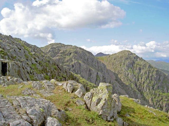
Photo: Ian Greig via Geograph, CC BY-SA 2.0
About Crinkle Crags (Long Top)
One of the best ridge walks in the Lakes, full of knobbly summits and rocky steps. The Bad Step gives a short optional scramble for the confident, while bypass paths keep things accessible. The Long Top is the highest point with superb outlooks to Bowfell and the Scafells. A day of constant interest and big mountain flavour.
Start in Great Langdale, at the National Trust car park by the Old Dungeon Ghyll Hotel at the end of the valley road. The 516 bus from Ambleside ends there too. The top of Wrynose Pass gives the shortest way onto the ridge, but most people walk the crinkles as a horseshoe round the head of Oxendale.
The classic round goes past Stool End Farm into Oxendale and up the stone path beside Browney Gill to the col at Red Tarn. Turn west past Great Knott onto the first crinkle, cross all five north to Three Tarns, and either come down The Band or carry on over Bowfell.
The Bad Step
Long Top, the highest point, is the second crinkle. Just before it the ridge is blocked by a short, steep gully with two chockstones jammed in it. You can climb straight up on good holds, but most walkers take the easier bypass that zigzags up on the left. The Bad Step catches out more people going north to south, when they arrive at the top of it by surprise.
The rest of the ridge is rocky and rough, with scree on the steep bits and short clambers over boulders all the way. There is rarely one clear path, just several boot-worn lines, and in places crags drop away close by. In mist the twists of the ridge make it hard to be sure which crinkle you are on, so keep your map and compass handy.
From Long Top you look down into Great Langdale, Eskdale and Dunnerdale, out to the estuaries on the coast, and across to Scafell Pike about four kilometres to the north west.
In winter
The Bad Step fills with ice and hard snow, and even the bypass path on its left is steep enough to need crampons. The full Oxendale round over the crinkles and down The Band takes most of a December day's light, so turn back at Red Tarn if you are behind time.
- Ridge Walk
- Scramble
- Great Views
- Potentially Dangerous
- Popular
Sources: Wikipedia: Crinkle Crags, Walk Lakes: Crinkle Crags. Updated .
Summit
- OS grid ref
- NY 248 048
- Latitude
- 54.43369° N
- Longitude
- 3.15979° W
- Area
- Southern Fells
Walking up Crinkle Crags (Long Top)
The nearest car park on foot is Old Dungeon Ghyll, 5.8 km (3.6 miles) from the summit along mapped paths. Directions to the car park
Route from Old Dungeon Ghyll
- Distance
- 5.8 km
- 3.6 miles, one way
- Ascent
- 778 m
- Total climb to the summit
- Time up
- 2 h 21 min
- Allow 1 to 3 hours
Times use Naismith’s rule, 5 km/h on the flat plus extra time for the climb, with Langmuir’s corrections. It’s a rule of thumb for the way up only, so add stops, weather and the walk back down.
The route follows paths mapped by OpenStreetMap contributors and isn’t a guided line. Check the mountain forecast before you go and carry a map and compass.
Crinkle Crags (Long Top) questions
Is Crinkle Crags (Long Top) a Wainwright?
How high is Crinkle Crags (Long Top)?
Where do you park for Crinkle Crags (Long Top)?
How long does it take to climb Crinkle Crags (Long Top)?
How hard is Crinkle Crags (Long Top)?
Which Wainwrights are near Crinkle Crags (Long Top)?
What is the grid reference for the summit of Crinkle Crags (Long Top)?
Often walked with Crinkle Crags (Long Top)
Fells people usually take in on the same day.
Crinkle Crags (Long Top) in our guides
Wainwrights near Crinkle Crags (Long Top)
Straight-line distance and direction from the summit.
 Bowfell903 m1.6 km N
 Cold Pike701 m1.9 km SE
 Pike o'Blisco705 m2.3 km E
 Rossett Pike651 m2.7 km N
 Esk Pike885 m2.9 km NW
 Hard Knott549 m3.0 km SW
More in the Southern Fells
- Scafell Pike978 m
- Scafell964 m
- Great End910 m
- Bowfell903 m
- Esk Pike885 m
- Lingmell807 m
- Coniston Old Man802 m
- Swirl How802 m
- Brim Fell796 m
- Allen Crags785 m
- Great Carrs785 m
- Glaramara783 m
- Dow Crag778 m
- Grey Friar773 m
- Wetherlam763 m
- Slight Side762 m
- Pike o'Blisco705 m
- Cold Pike701 m
- Harter Fell [Eskdale]654 m
- Rossett Pike651 m
- Illgill Head609 m
- Seathwaite Fell601 m
- Rosthwaite Fell (Bessyboot)551 m
- Hard Knott549 m
- Whin Rigg537 m
- Green Crag489 m
- Lingmoor Fell470 m
- Black Fell323 m
- Holme Fell317 m
Bag Crinkle Crags (Long Top) with Upfell
Reach the summit and capture Crinkle Crags (Long Top), even with no signal. It goes on your round of the 214 with its own patch.
Coming soon to theApp Store