Southern Fells · Book 4
Holme Fell
Holme Fell is a Wainwright, one of the 214 Lake District fells in Alfred Wainwright’s Pictorial Guides. At 317 m (1,040 ft) it is the 213th highest of the 214 and the lowest in the Southern Fells.
- Height
- 317 m
- 1,040 ft
- Rank
- 213
- of 214
- In area
- 30
- of 30
- Difficulty
- Easy
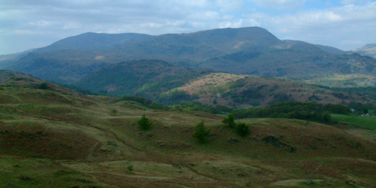
Photo: StephenDawson via Wikimedia Commons
About Holme Fell
A patchwork of birch woods, quarries and open tops above Yew Tree Tarn. Short, punchy climbs lead to craggy viewpoints over the Coniston range. Plenty of nooks for photos and quiet picnics.
Hodge Close, on the north side of the fell, is a huge disused green slate quarry that closed just before the Second World War. It is flooded now, with sheer drops into the water. Rock climbers use its walls, and several divers have died after getting lost in its underwater tunnels. Look, but keep back from the edge.
The fell is a ridge about a mile and a half long, running north to south, with roads and tracks all round it, so circular walks are easy to plan. Walkers start from Holme Ground, Hodge Close, Yew Tree Tarn or Yew Tree Farm. There is parking beside Yew Tree Tarn on the Coniston road and at Glen Mary Bridge, and the last two starts link with the circuit of Tarn Hows. A popular loop goes over Black Fell first, crosses the A593 and climbs Holme Fell from Hodge Close.
The walking is straightforward. A few steep rocky bits below the summit need some clambering, but nothing counts as a scramble.
Ivy Crag, the northern top, carries a large cairn. The true top is further south at 317 metres, between Calf Crag and Raven Crag. West of Uskdale Gap, two small reservoirs once supplied water to work a funicular that raised slate out of the quarry. Because the fell stands on its own, the views north, south and east are good for its height, with nearly all of Coniston Water below and the Langdale fells in the distance. Wetherlam blocks the view to the south-west.
Yew Tree Tarn, beside the road, was dammed in the 1930s and holds trout.
In winter
Steep rocky steps below the summit need care when wet or icy, and the paths through the woods to Uskdale Gap hold ice in the shade. Keep well back from the flooded Hodge Close quarry, whose edges drop straight into deep water.
- Great Views
- Family Walk
- Kid Friendly
- Dog Friendly
Sources: Wikipedia: Holme Fell, Walk Lakes: Tarn Hows, Black Fell, Holme Fell. Updated .
Summit
- OS grid ref
- NY 315 006
- Latitude
- 54.39676° N
- Longitude
- 3.05609° W
- Area
- Southern Fells
Walking up Holme Fell
The nearest car park on foot is Low Tilberthwaite, 1.8 km (1.1 miles) from the summit along mapped paths. Directions to the car park
Route from Low Tilberthwaite
- Distance
- 1.8 km
- 1.1 miles, one way
- Ascent
- 164 m
- Total climb to the summit
- Time up
- 36 min
- Allow 1 to 2 hours
Times use Naismith’s rule, 5 km/h on the flat plus extra time for the climb, with Langmuir’s corrections. It’s a rule of thumb for the way up only, so add stops, weather and the walk back down.
The route follows paths mapped by OpenStreetMap contributors and isn’t a guided line. Check the mountain forecast before you go and carry a map and compass.
Holme Fell questions
Is Holme Fell a Wainwright?
How high is Holme Fell?
Where do you park for Holme Fell?
How long does it take to climb Holme Fell?
How hard is Holme Fell?
Which Wainwrights are near Holme Fell?
What is the grid reference for the summit of Holme Fell?
Often walked with Holme Fell
Fells people usually take in on the same day.
Holme Fell in our guides
Wainwrights near Holme Fell
Straight-line distance and direction from the summit.
 Black Fell323 m2.7 km E
 Wetherlam763 m2.7 km W
 Lingmoor Fell470 m4.1 km N
 Swirl How802 m4.2 km W
 Great Carrs785 m4.4 km W
 Brim Fell796 m4.9 km SW
More in the Southern Fells
- Scafell Pike978 m
- Scafell964 m
- Great End910 m
- Bowfell903 m
- Esk Pike885 m
- Crinkle Crags (Long Top)859 m
- Lingmell807 m
- Coniston Old Man802 m
- Swirl How802 m
- Brim Fell796 m
- Allen Crags785 m
- Great Carrs785 m
- Glaramara783 m
- Dow Crag778 m
- Grey Friar773 m
- Wetherlam763 m
- Slight Side762 m
- Pike o'Blisco705 m
- Cold Pike701 m
- Harter Fell [Eskdale]654 m
- Rossett Pike651 m
- Illgill Head609 m
- Seathwaite Fell601 m
- Rosthwaite Fell (Bessyboot)551 m
- Hard Knott549 m
- Whin Rigg537 m
- Green Crag489 m
- Lingmoor Fell470 m
- Black Fell323 m
Bag Holme Fell with Upfell
Reach the summit and capture Holme Fell, even with no signal. It goes on your round of the 214 with its own patch.
Coming soon to theApp Store