Southern Fells · Book 4
Dow Crag
Dow Crag is a Wainwright, one of the 214 Lake District fells in Alfred Wainwright’s Pictorial Guides. At 778 m (2,552 ft) it is the 48th highest of the 214 and the 14th highest in the Southern Fells.
- Height
- 778 m
- 2,552 ft
- Rank
- 48
- of 214
- In area
- 14
- of 30
- Difficulty
- Moderate
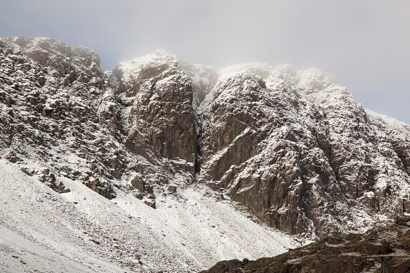
Photo: Rob Noble via Geograph, CC BY-SA 2.0
About Dow Crag
A proud cliff‑backed top whose eastern face drops in grand buttresses towards Goats Water. Classic links to Coniston Old Man make it a star of the Coniston round.
Above Goat's Water, Dow Crag is a wall of rhyolite buttresses about 100 metres high, with more than a hundred climbing routes on it. Walkers come at the top from behind, where the ground is far kinder, and many pair it with the Old Man for a horseshoe round the tarn.
The simplest way up uses the Walna Scar Road. Park at the fell gate car park above Coniston, walk the old road to the top of the pass, then turn north along the ridge over Brown Pike and Buck Pike. From Torver, a walled bridleway climbs past Banishead Quarry to join the same road, a route of about 3.8 miles and 2,400 feet. To see the crag close up, leave the road at The Cove, go up to Goat's Water and climb to Goat's Hawse at the head of the tarn. South Rake, a gully through the crag, is the easiest way up the face and a fairly easy scramble.
Between Goat's Hawse and the top, the ridge is steep and rough on the Dow Crag side. There is no summit cairn, only a rock point right on the edge above the gullies, so take care in wind.
The view south and west over the coast and estuaries is the best of it. The Old Man and its neighbours hide most of the Lakes, but the Scafells, Skiddaw and the Helvellyn range show through the gaps. Goat's Water keeps its natural shape and holds trout and char, and Blind Tarn lies in a hollow below Brown Pike.
In winter
The rough, steep climb from Goat's Hawse runs right above the drop to Goat's Water, and the summit is a rock point on the lip of the crag, so ice or poor visibility makes both serious. In mist keep to the west side of the ridge.
- Great Views
- Dog Friendly
Sources: Wikipedia: Dow Crag, Wainwright Routes: Dow Crag Route One. Updated .
Summit
- OS grid ref
- SD 262 977
- Latitude
- 54.37029° N
- Longitude
- 3.13663° W
- Area
- Southern Fells
Walking up Dow Crag
The nearest car park on foot is Coppermines and Old Man Car Park, 4.9 km (3.1 miles) from the summit along mapped paths. Directions to the car park
Route from Coppermines and Old Man Car Park
- Distance
- 4.9 km
- 3.1 miles, one way
- Ascent
- 748 m
- Total climb to the summit
- Time up
- 2 h 10 min
- Allow 1 to 3 hours
Times use Naismith’s rule, 5 km/h on the flat plus extra time for the climb, with Langmuir’s corrections. It’s a rule of thumb for the way up only, so add stops, weather and the walk back down.
The route follows paths mapped by OpenStreetMap contributors and isn’t a guided line. This car park was picked automatically and hasn’t been checked by hand yet, so compare it with a map. Check the mountain forecast before you go and carry a map and compass.
Dow Crag questions
Is Dow Crag a Wainwright?
How high is Dow Crag?
Where do you park for Dow Crag?
How long does it take to climb Dow Crag?
How hard is Dow Crag?
Which Wainwrights are near Dow Crag?
What is the grid reference for the summit of Dow Crag?
Often walked with Dow Crag
Fells people usually take in on the same day.
Dow Crag in our guides
Wainwrights near Dow Crag
Straight-line distance and direction from the summit.
 Coniston Old Man802 m1.0 km E
 Brim Fell796 m1.1 km NE
 Grey Friar773 m2.6 km N
 Swirl How802 m2.9 km N
 Great Carrs785 m3.3 km N
 Wetherlam763 m4.2 km NE
More in the Southern Fells
- Scafell Pike978 m
- Scafell964 m
- Great End910 m
- Bowfell903 m
- Esk Pike885 m
- Crinkle Crags (Long Top)859 m
- Lingmell807 m
- Coniston Old Man802 m
- Swirl How802 m
- Brim Fell796 m
- Allen Crags785 m
- Great Carrs785 m
- Glaramara783 m
- Grey Friar773 m
- Wetherlam763 m
- Slight Side762 m
- Pike o'Blisco705 m
- Cold Pike701 m
- Harter Fell [Eskdale]654 m
- Rossett Pike651 m
- Illgill Head609 m
- Seathwaite Fell601 m
- Rosthwaite Fell (Bessyboot)551 m
- Hard Knott549 m
- Whin Rigg537 m
- Green Crag489 m
- Lingmoor Fell470 m
- Black Fell323 m
- Holme Fell317 m
Bag Dow Crag with Upfell
Reach the summit and capture Dow Crag, even with no signal. It goes on your round of the 214 with its own patch.
Coming soon to theApp Store