Southern Fells · Book 4
Black Fell
Black Fell is a Wainwright, one of the 214 Lake District fells in Alfred Wainwright’s Pictorial Guides. At 323 m (1,060 ft) it is the 212th highest of the 214 and the 29th highest in the Southern Fells.
- Height
- 323 m
- 1,060 ft
- Rank
- 212
- of 214
- In area
- 29
- of 30
- Difficulty
- Easy
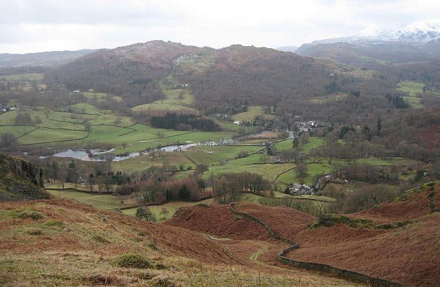
Photo: Ann Bowker
About Black Fell
Low in height but high on views, with Windermere and the Coniston fells in frame. Forest tracks and open fell give a gentle ascent. Ideal for a calm day when the higher tops are clagged in.
Start at Tarn Hows. The National Trust car park there is the largest nearby and has toilets, and there is more parking at Glen Mary Bridge and Yew Tree Tarn on the Coniston road. From the tarn, follow the signed path towards Arnside, then turn up a rough track marked for Iron Keld. It climbs steeply through the plantation at first, then levels off and comes out on the open top. Other ways up start at Skelwith Bridge, High Park, Oxen Fell and Knipe Fold, and a bridleway known locally as the mountain road crosses the fell between the A593 and Knipe Fold.
The fell is roughly a mile by two, mostly rough grass and small outcrops, with broadleaved woods on the lower slopes. Walk Lakes grades the going as rough with some soft ground, and warns that a few signposts have gone missing.
Maps mark the top as Black Crag, which flatters it a little. A trig pillar carries a National Trust sign, and a big cairn about 200 yards east has the best view down Windermere. At 323 metres you look across to the Coniston and Langdale fells on one side and over the southern lakes and lowlands on the other. For the view north, walk over to Great Cobble.
James Marshall laid out Tarn Hows as a piece of landscape design in the 1860s. The land passed from the Marshall family to Beatrix Potter and then to the National Trust. Holme Fell is just across the main road, and the two make a longer loop.
In winter
At 323 metres, with no crags on the paths, it is a sensible choice when the higher fells are in cloud or snow. The steep, rough track up through Iron Keld plantation is the part that ices.
- Great Views
- Family Walk
- Kid Friendly
- Dog Friendly
Sources: Wikipedia: Black Fell (Lake District), Walk Lakes: Tarn Hows, Black Fell, Holme Fell. Updated .
Summit
- OS grid ref
- NY 340 015
- Latitude
- 54.40549° N
- Longitude
- 3.01793° W
- Area
- Southern Fells
Walking up Black Fell
The nearest car park on foot is N.T. Disabled Parking, 2.7 km (1.7 miles) from the summit along mapped paths. Directions to the car park
Route from N.T. Disabled Parking
- Distance
- 2.7 km
- 1.7 miles, one way
- Ascent
- 117 m
- Total climb to the summit
- Time up
- 43 min
- Allow 1 to 2 hours
Times use Naismith’s rule, 5 km/h on the flat plus extra time for the climb, with Langmuir’s corrections. It’s a rule of thumb for the way up only, so add stops, weather and the walk back down.
The route follows paths mapped by OpenStreetMap contributors and isn’t a guided line. This car park was picked automatically and hasn’t been checked by hand yet, so compare it with a map. Check the mountain forecast before you go and carry a map and compass.
Black Fell questions
Is Black Fell a Wainwright?
How high is Black Fell?
Where do you park for Black Fell?
How long does it take to climb Black Fell?
How hard is Black Fell?
Which Wainwrights are near Black Fell?
What is the grid reference for the summit of Black Fell?
Often walked with Black Fell
Fells people usually take in on the same day.
Black Fell in our guides
Wainwrights near Black Fell
Straight-line distance and direction from the summit.
 Holme Fell317 m2.7 km W
 Loughrigg Fell335 m3.6 km N
 Lingmoor Fell470 m4.8 km NW
 Wetherlam763 m5.2 km W
 Silver How395 m5.3 km N
 Nab Scar450 m5.8 km N
More in the Southern Fells
- Scafell Pike978 m
- Scafell964 m
- Great End910 m
- Bowfell903 m
- Esk Pike885 m
- Crinkle Crags (Long Top)859 m
- Lingmell807 m
- Coniston Old Man802 m
- Swirl How802 m
- Brim Fell796 m
- Allen Crags785 m
- Great Carrs785 m
- Glaramara783 m
- Dow Crag778 m
- Grey Friar773 m
- Wetherlam763 m
- Slight Side762 m
- Pike o'Blisco705 m
- Cold Pike701 m
- Harter Fell [Eskdale]654 m
- Rossett Pike651 m
- Illgill Head609 m
- Seathwaite Fell601 m
- Rosthwaite Fell (Bessyboot)551 m
- Hard Knott549 m
- Whin Rigg537 m
- Green Crag489 m
- Lingmoor Fell470 m
- Holme Fell317 m
Bag Black Fell with Upfell
Reach the summit and capture Black Fell, even with no signal. It goes on your round of the 214 with its own patch.
Coming soon to theApp Store