Central Fells · Book 3
Loughrigg Fell
Loughrigg Fell is a Wainwright, one of the 214 Lake District fells in Alfred Wainwright’s Pictorial Guides. At 335 m (1,099 ft) it is the 211th highest of the 214 and the lowest in the Central Fells.
- Height
- 335 m
- 1,099 ft
- Rank
- 211
- of 214
- In area
- 27
- of 27
- Difficulty
- Moderate
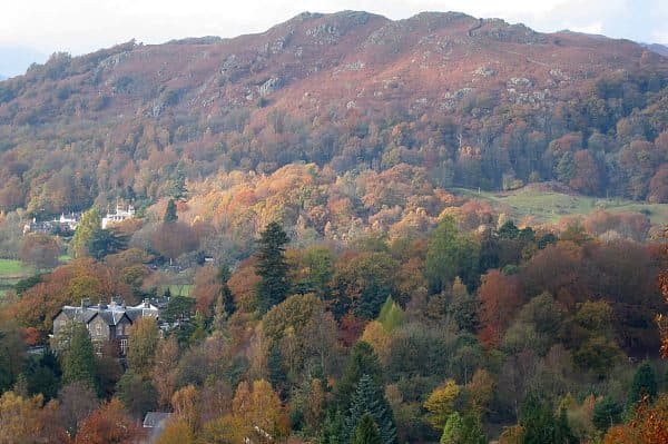
Photo: Ann Bowker
About Loughrigg Fell
A maze of knolls, terraces and little tarns between Ambleside and Grasmere. Endlessly variable routes make it perfect for golden hour wanders. The summit looks straight to the Langdale Pikes for maximum reward.
Loughrigg is small, but you can climb it from almost anywhere. Ambleside, Rydal, Grasmere, Skelwith Bridge and Elterwater all have paths onto it. The most popular start is White Moss on the A591 between Rydal Water and Grasmere, where there are two National Park pay and display car parks about 150m apart. The 555 bus between Keswick and Lancaster stops at White Moss Common, so you can do it without a car.
From White Moss, cross the River Rothay and go through the woods to Loughrigg Terrace, a level path above Grasmere with good views up the lake. At the western end a steep path with stone steps climbs to the summit plateau. A good circuit carries on across the top and comes down past Rydal Cave, a large 19th century slate quarry chamber with stepping stones across the pool at its mouth. Blocks do occasionally fall from its roof.
Low down the tracks are good. On top the paths are rough and sometimes boggy, and they fork and wander between rocky knolls. There is no scrambling.
The summit
The highest point is the middle one of three knolls and has an Ordnance Survey trig pillar beside a large cairn. The view is wide for the height. The Langdale Pikes are the main feature to the west, the Fairfield Horseshoe is to the north east, and Windermere, Elterwater and Grasmere are all in sight. Loughrigg Tarn sits in its hollow below the south western slopes.
In winter
The top of Loughrigg is a maze of near-identical knolls and hollows, and in low cloud or snow it is easy to lose the path and head off the wrong way. The stone-pitched steps between the summit and Loughrigg Terrace get slick with ice.
- Summit Tarn
- Popular
- Kid Friendly
- Family Walk
- Dog Friendly
Sources: Wikipedia: Loughrigg Fell, Walk Lakes: Loughrigg Fell from White Moss. Updated .
Summit
- OS grid ref
- NY 346 051
- Latitude
- 54.43744° N
- Longitude
- 3.00833° W
- Area
- Central Fells
Walking up Loughrigg Fell
The nearest car park on foot is White Moss Common (Upper), 2.4 km (1.5 miles) from the summit along mapped paths. Directions to the car park
Route from White Moss Common (Upper)
- Distance
- 2.4 km
- 1.5 miles, one way
- Ascent
- 277 m
- Total climb to the summit
- Time up
- 55 min
- Allow 1 to 2 hours
Times use Naismith’s rule, 5 km/h on the flat plus extra time for the climb, with Langmuir’s corrections. It’s a rule of thumb for the way up only, so add stops, weather and the walk back down.
The route follows paths mapped by OpenStreetMap contributors and isn’t a guided line. This car park was picked automatically and hasn’t been checked by hand yet, so compare it with a map. Check the mountain forecast before you go and carry a map and compass.
Loughrigg Fell questions
Is Loughrigg Fell a Wainwright?
How high is Loughrigg Fell?
Where do you park for Loughrigg Fell?
How long does it take to climb Loughrigg Fell?
How hard is Loughrigg Fell?
Which Wainwrights are near Loughrigg Fell?
What is the grid reference for the summit of Loughrigg Fell?
Often walked with Loughrigg Fell
Fells people usually take in on the same day.
Loughrigg Fell in our guides
- Dog-friendly Wainwrights: fells, leads and livestock
- Doing the Wainwrights together: couples, clubs and dogs
- Wainwrights by bus: the Lake District without a car
- Wainwrights for beginners: a first-timer's guide
- Wainwrights for kids: easy fells for children
- Wainwrights from Ambleside
- Wainwrights from Grasmere
- Wainwrights to avoid in bad weather, and where to go instead
- Wainwrights with summit tarns
- Winter Wainwrights: fells you can still reach when the passes shut
Wainwrights near Loughrigg Fell
Straight-line distance and direction from the summit.
 Nab Scar450 m2.3 km N
 Silver How395 m2.7 km NW
 Heron Pike612 m3.3 km N
 Black Fell323 m3.6 km S
 Low Pike508 m3.8 km NE
 Stone Arthur504 m4.1 km N
More in the Central Fells
- High Raise [Langdale]762 m
- Harrison Stickle736 m
- Sergeant Man736 m
- Ullscarf726 m
- Thunacar Knott723 m
- Pike o'Stickle708 m
- Pavey Ark700 m
- Loft Crag682 m
- High Seat608 m
- Bleaberry Fell590 m
- Sergeant's Crag571 m
- Blea Rigg556 m
- Steel Fell553 m
- Tarn Crag [Easedale]551 m
- Calf Crag537 m
- Eagle Crag525 m
- High Tove515 m
- Armboth Fell475 m
- Raven Crag461 m
- Great Crag449 m
- Gibson Knott420 m
- Grange Fell (Brund Fell)417 m
- Helm Crag405 m
- Silver How395 m
- Walla Crag379 m
- High Rigg357 m
Bag Loughrigg Fell with Upfell
Reach the summit and capture Loughrigg Fell, even with no signal. It goes on your round of the 214 with its own patch.
Coming soon to theApp Store