Central Fells · Book 3
Helm Crag
Helm Crag is a Wainwright, one of the 214 Lake District fells in Alfred Wainwright’s Pictorial Guides. At 405 m (1,329 ft) it is the 201st highest of the 214 and the 23rd highest in the Central Fells.
- Height
- 405 m
- 1,329 ft
- Rank
- 201
- of 214
- In area
- 23
- of 27
- Difficulty
- Moderate
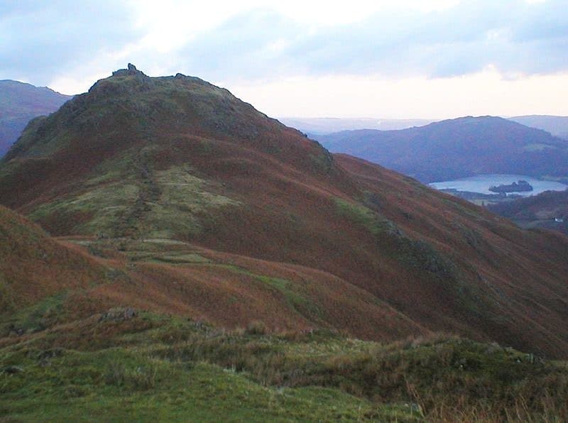
Photo: Harthacanute via Wikimedia Commons
About Helm Crag
A Grasmere favourite with a rocky crown. The Lion and the Lamb are the rocks at its south-east end that you see from the village, and the true summit is the Howitzer at the north-west end. Short and steep in places, the ridge gives cracking views over Easedale and the Central Fells. The Howitzer is a scramble on rough rock, so take care in the wet.
You can walk to the foot of Helm Crag from any of the Grasmere car parks, and the 555 bus between Kendal and Keswick stops in the village. Take Easedale Road, opposite the outdoor shop, past the youth hostel and over Goody Bridge, then turn right at the cottages onto the track signed for Helm Crag. At the top of the lane a gate leads onto the fell.
The path climbs the south-east end in a long series of zigzags, much of it rebuilt by the National Trust with steps and drainage. Higher up it gets a little rocky, and in the wet you can take the bypasses to the left. The summit ridge is a jumble of shattered blocks rather than a single top, so take your time on it.
The Howitzer
The crest has two short ridges running north-west to south-east with a hollow between them. The rocks at the south-east end are the Lion and the Lamb you see from Grasmere, and most walkers stop there. The true summit is the tilted tower at the north-west end, called the Howitzer. Getting onto it takes an awkward, exposed scramble, and plenty of experienced walkers pass it up. From the ridge you see the Langdale Pikes, the Coniston fells and the Eastern Fells.
The summit rocks get different names depending on where you see them from. From Dunmail Raise they look like a howitzer. From other angles people call them the Lion Couchant or the Old Lady Playing the Organ. For a longer day, carry on north-west along the ridge over Gibson Knott to Calf Crag and return down Far Easedale.
In winter
The Howitzer's tilted slab is no place to be when it is iced or wet, so leave it and settle for the lower summit rocks. The engineered steps on the zigzags hold frost, but the fell is low and short enough for a winter afternoon when the bigger tops are out of condition.
- Ridge Walk
- Scramble
- Great Views
- Potentially Dangerous
- Popular
Sources: Wikipedia: Helm Crag, Walk Lakes: Helm Crag. Updated .
Summit
- OS grid ref
- NY 326 093
- Latitude
- 54.47501° N
- Longitude
- 3.04080° W
- Area
- Central Fells
Walking up Helm Crag
The nearest car park on foot is Easedale Tarn Car Park, 2.0 km (1.3 miles) from the summit along mapped paths. Directions to the car park
Route from Easedale Tarn Car Park
- Distance
- 2.0 km
- 1.3 miles, one way
- Ascent
- 320 m
- Total climb to the summit
- Time up
- 53 min
- Allow 1 to 2 hours
Times use Naismith’s rule, 5 km/h on the flat plus extra time for the climb, with Langmuir’s corrections. It’s a rule of thumb for the way up only, so add stops, weather and the walk back down.
The route follows paths mapped by OpenStreetMap contributors and isn’t a guided line. Check the mountain forecast before you go and carry a map and compass.
Helm Crag questions
Is Helm Crag a Wainwright?
How high is Helm Crag?
Where do you park for Helm Crag?
How long does it take to climb Helm Crag?
How hard is Helm Crag?
Which Wainwrights are near Helm Crag?
What is the grid reference for the summit of Helm Crag?
Often walked with Helm Crag
Fells people usually take in on the same day.
Helm Crag in our guides
Wainwrights near Helm Crag
Straight-line distance and direction from the summit.
 Gibson Knott420 m1.0 km NW
 Steel Fell553 m1.9 km N
 Stone Arthur504 m2.1 km E
 Tarn Crag [Easedale]551 m2.3 km W
 Calf Crag537 m2.7 km W
 Silver How395 m2.7 km S
More in the Central Fells
- High Raise [Langdale]762 m
- Harrison Stickle736 m
- Sergeant Man736 m
- Ullscarf726 m
- Thunacar Knott723 m
- Pike o'Stickle708 m
- Pavey Ark700 m
- Loft Crag682 m
- High Seat608 m
- Bleaberry Fell590 m
- Sergeant's Crag571 m
- Blea Rigg556 m
- Steel Fell553 m
- Tarn Crag [Easedale]551 m
- Calf Crag537 m
- Eagle Crag525 m
- High Tove515 m
- Armboth Fell475 m
- Raven Crag461 m
- Great Crag449 m
- Gibson Knott420 m
- Grange Fell (Brund Fell)417 m
- Silver How395 m
- Walla Crag379 m
- High Rigg357 m
- Loughrigg Fell335 m
Bag Helm Crag with Upfell
Reach the summit and capture Helm Crag, even with no signal. It goes on your round of the 214 with its own patch.
Coming soon to theApp Store