Central Fells · Book 3
Pavey Ark
Pavey Ark is a Wainwright, one of the 214 Lake District fells in Alfred Wainwright’s Pictorial Guides. At 700 m (2,297 ft) it is the 89th highest of the 214 and the 7th highest in the Central Fells.
- Height
- 700 m
- 2,297 ft
- Rank
- 89
- of 214
- In area
- 7
- of 27
- Difficulty
- Moderate
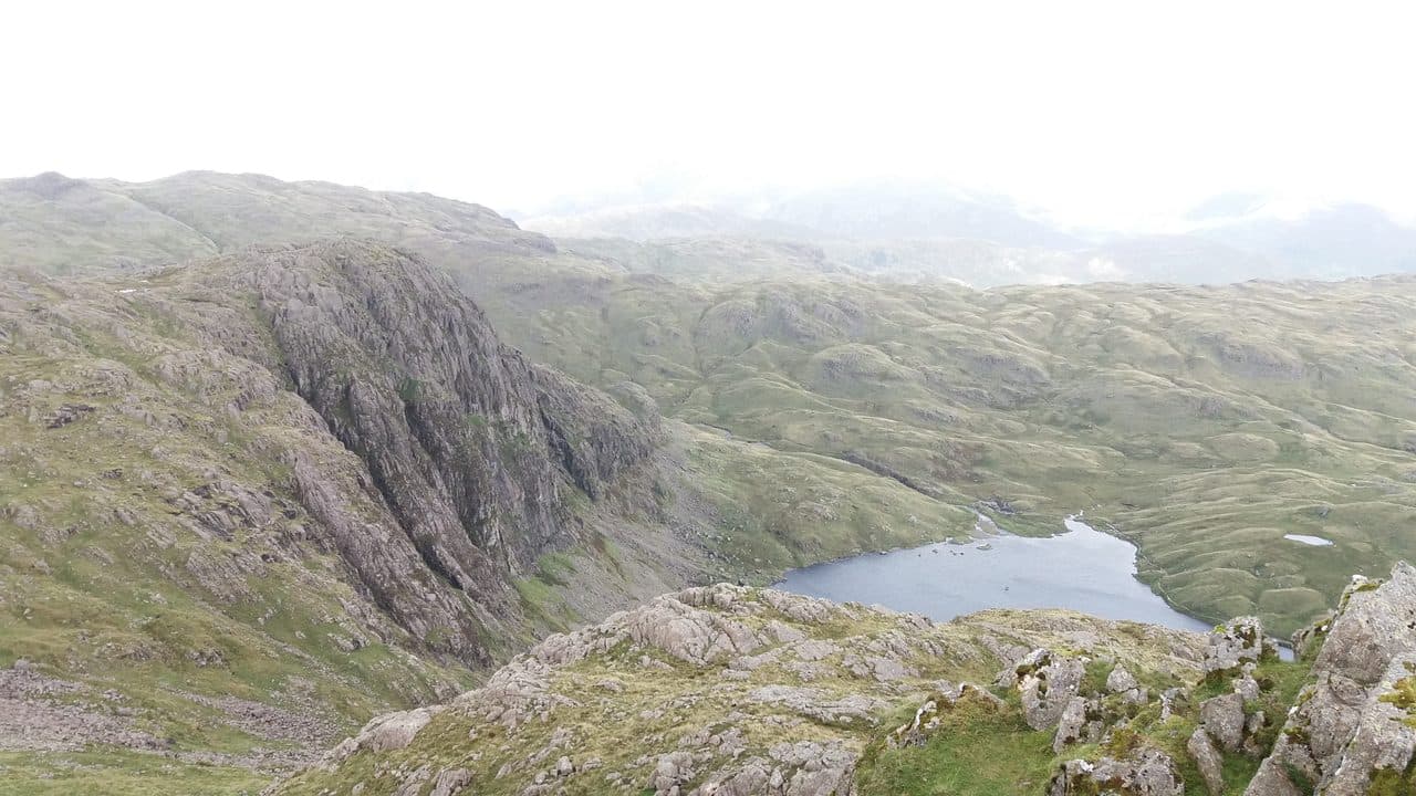
Photo: Mmitchell10 via Wikimedia Commons
About Pavey Ark
Home to the famous Jack's Rake on its dramatic face. The rocky summit sits back from the edge, and the best views over Stickle Tarn and the Langdale Pikes are from the rim. Stick to the walkers' paths if you'd rather avoid scrambling.
Pavey Ark is the big dark cliff rising straight out of the back of Stickle Tarn, and it is the largest crag in the Langdales.
Park at the National Trust car park at New Dungeon Ghyll, next to the Sticklebarn, or take the 516 bus from Ambleside, which stops there. The path up Stickle Ghyll is a mix of stone pitching and rough boulders and crosses the beck twice. The east bank line is the easier of the two. At Stickle Tarn, dammed long ago for water supply, the whole face is in front of you.
Three ways up the crag
Jack's Rake is the famous one, a Grade 1 scramble that climbs diagonally leftwards across the face in a natural groove. A low parapet of rock on the outside makes it feel less exposed than it looks, but it is steep, polished in places and a serious fall risk when wet. Two people died in falls from it in June 2012. Near its foot, look for a stone marked JWS 1900. Easy Gully, further east, is steep scree with some boulder moves near the top.
If you want no scrambling, walk round the east shore of the tarn, follow Bright Beck and take the path up the east ridge that Wainwright named North Rake. It is steep and rough in a cairned gully, but you never need your hands.
The top is bare rock, a short distance north of where Jack's Rake comes out. High Raise blocks some of the view to the north west, but you look across Harrison Combe to Pike of Stickle and out over the Eastern and Southern Fells. Most people carry on to Harrison Stickle and the other Pikes.
In winter
In snow and ice Jack's Rake stops being a walkers' scramble and becomes a winter climb, and the North Rake gully can fill with hard snow. The Stickle Ghyll path is stone pitched and very slippery when iced, so on short days allow for coming down it in failing light.
- Scramble
- Great Views
- Popular
- Potentially Dangerous
Sources: Wikipedia: Pavey Ark, Walk Lakes: The Langdale Pikes from New Dungeon Ghyll. Updated .
Summit
- OS grid ref
- NY 284 079
- Latitude
- 54.46148° N
- Longitude
- 3.10519° W
- Area
- Central Fells
Walking up Pavey Ark
The nearest car park on foot is New Dungeon Ghyll, 2.8 km (1.7 miles) from the summit along mapped paths. Directions to the car park
Route from New Dungeon Ghyll
- Distance
- 2.8 km
- 1.7 miles, one way
- Ascent
- 613 m
- Total climb to the summit
- Time up
- 1 h 31 min
- Allow 1 to 2 hours
Times use Naismith’s rule, 5 km/h on the flat plus extra time for the climb, with Langmuir’s corrections. It’s a rule of thumb for the way up only, so add stops, weather and the walk back down.
The route follows paths mapped by OpenStreetMap contributors and isn’t a guided line. This car park was picked automatically and hasn’t been checked by hand yet, so compare it with a map. Check the mountain forecast before you go and carry a map and compass.
Pavey Ark questions
Is Pavey Ark a Wainwright?
How high is Pavey Ark?
Where do you park for Pavey Ark?
How long does it take to climb Pavey Ark?
How hard is Pavey Ark?
Which Wainwrights are near Pavey Ark?
What is the grid reference for the summit of Pavey Ark?
Often walked with Pavey Ark
Fells people usually take in on the same day.
Pavey Ark in our guides
Wainwrights near Pavey Ark
Straight-line distance and direction from the summit.
 Harrison Stickle736 m0.6 km SW
 Thunacar Knott723 m0.6 km W
 Sergeant Man736 m1.0 km N
 Loft Crag682 m1.0 km SW
 Pike o'Stickle708 m1.2 km SW
 High Raise [Langdale]762 m1.7 km N
More in the Central Fells
- High Raise [Langdale]762 m
- Harrison Stickle736 m
- Sergeant Man736 m
- Ullscarf726 m
- Thunacar Knott723 m
- Pike o'Stickle708 m
- Loft Crag682 m
- High Seat608 m
- Bleaberry Fell590 m
- Sergeant's Crag571 m
- Blea Rigg556 m
- Steel Fell553 m
- Tarn Crag [Easedale]551 m
- Calf Crag537 m
- Eagle Crag525 m
- High Tove515 m
- Armboth Fell475 m
- Raven Crag461 m
- Great Crag449 m
- Gibson Knott420 m
- Grange Fell (Brund Fell)417 m
- Helm Crag405 m
- Silver How395 m
- Walla Crag379 m
- High Rigg357 m
- Loughrigg Fell335 m
Bag Pavey Ark with Upfell
Reach the summit and capture Pavey Ark, even with no signal. It goes on your round of the 214 with its own patch.
Coming soon to theApp Store