Central Fells · Book 3
Walla Crag
Walla Crag is a Wainwright, one of the 214 Lake District fells in Alfred Wainwright’s Pictorial Guides. At 379 m (1,243 ft) it is the 204th highest of the 214 and the 25th highest in the Central Fells.
- Height
- 379 m
- 1,243 ft
- Rank
- 204
- of 214
- In area
- 25
- of 27
- Difficulty
- Easy
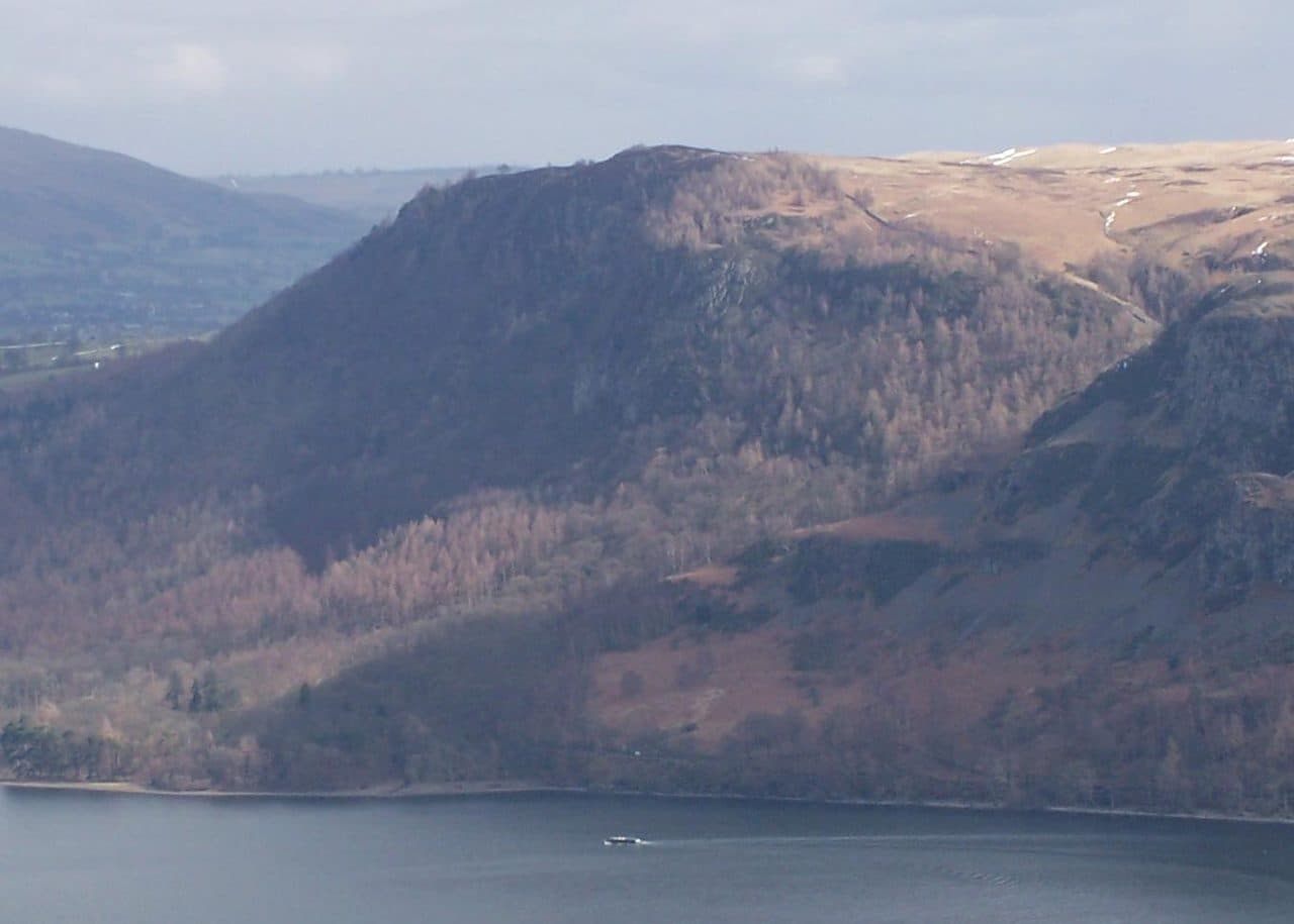
Photo: Mick Knapton via Wikimedia Commons
About Walla Crag
Keswick’s balcony, looking straight down over Derwentwater and the jaws of Borrowdale. Well trodden paths and a compact outing make it ideal for a quick leg stretch. Pair it with Ashness Bridge and Surprise View for a crowd-pleaser loop.
Walla Crag ends in a steep cliff about 400 feet high, dropping through trees towards Derwentwater, and the best views are from its edge. Take care near the drop. The summit cairn sits a little way back, and a wall runs behind the edge, which helps in mist.
Most walkers start from the National Trust pay and display car park at Great Wood, on the Borrowdale road a couple of miles south of Keswick. The 78 Borrowdale bus from Keswick runs along that road. From the car park you can climb through the woods and up Cat Gill, a steep gorge with small waterfalls and a stone-pitched path, or take the gentler way round by Rakefoot and Brockle Beck. A loop up one and down the other is under 5 km. You can also walk straight out of Keswick via Brockle Beck and leave the car behind altogether.
The Cat Gill path is steep and rough, and the stone steps are hard on knees in descent. The ground on top is boggy with sphagnum moss in places. There's no scrambling on the walking routes.
From the cliff top you see all of Derwentwater, with Keswick below and Skiddaw behind. Across the water are Grisedale Pike and the Newlands fells, and to the south you look down Borrowdale. If you want more, carry on up the broad moorland slope to Bleaberry Fell.
Lady's Rake
The only break in the crag is a steep gully called Lady's Rake. The story goes that the Countess of Derwentwater fled up it after her husband, the Earl, was captured in the Jacobite rising of 1715. He was executed the following year. It's not a walking route now, as the gully is loose and dangerous.
In winter
The stone-pitched steps up the Cat Gill gorge ice over and stay slippery for days after a freeze. On top, snow can hide how close the path runs to the cliff edge, so use the wall set back from the crag as your guide.
- Great Views
- Popular
- Family Walk
- Kid Friendly
- Dog Friendly
Sources: Wikipedia: Walla Crag, Walk Lakes: Walla Crag and the Great Wood, Walk My World: Walla Crag. Updated .
Summit
- OS grid ref
- NY 276 212
- Latitude
- 54.58159° N
- Longitude
- 3.12035° W
- Area
- Central Fells
Walking up Walla Crag
The nearest car park on foot is Great Wood, 1.5 km (0.9 miles) from the summit along mapped paths. Directions to the car park
Route from Great Wood
- Distance
- 1.5 km
- 0.9 miles, one way
- Ascent
- 280 m
- Total climb to the summit
- Time up
- 44 min
- Allow 1 to 2 hours
Times use Naismith’s rule, 5 km/h on the flat plus extra time for the climb, with Langmuir’s corrections. It’s a rule of thumb for the way up only, so add stops, weather and the walk back down.
The route follows paths mapped by OpenStreetMap contributors and isn’t a guided line. Check the mountain forecast before you go and carry a map and compass.
Walla Crag questions
Is Walla Crag a Wainwright?
How high is Walla Crag?
Where do you park for Walla Crag?
How long does it take to climb Walla Crag?
How hard is Walla Crag?
Which Wainwrights are near Walla Crag?
What is the grid reference for the summit of Walla Crag?
Often walked with Walla Crag
Fells people usually take in on the same day.
Walla Crag in our guides
Wainwrights near Walla Crag
Straight-line distance and direction from the summit.
 Bleaberry Fell590 m1.9 km SE
 High Rigg357 m3.2 km E
 High Seat608 m3.4 km S
 Latrigg368 m3.4 km N
 Catbells451 m3.6 km SW
 Raven Crag461 m3.7 km SE
More in the Central Fells
- High Raise [Langdale]762 m
- Harrison Stickle736 m
- Sergeant Man736 m
- Ullscarf726 m
- Thunacar Knott723 m
- Pike o'Stickle708 m
- Pavey Ark700 m
- Loft Crag682 m
- High Seat608 m
- Bleaberry Fell590 m
- Sergeant's Crag571 m
- Blea Rigg556 m
- Steel Fell553 m
- Tarn Crag [Easedale]551 m
- Calf Crag537 m
- Eagle Crag525 m
- High Tove515 m
- Armboth Fell475 m
- Raven Crag461 m
- Great Crag449 m
- Gibson Knott420 m
- Grange Fell (Brund Fell)417 m
- Helm Crag405 m
- Silver How395 m
- High Rigg357 m
- Loughrigg Fell335 m
Bag Walla Crag with Upfell
Reach the summit and capture Walla Crag, even with no signal. It goes on your round of the 214 with its own patch.
Coming soon to theApp Store