Central Fells · Book 3
Great Crag
Great Crag is a Wainwright, one of the 214 Lake District fells in Alfred Wainwright’s Pictorial Guides. At 449 m (1,473 ft) it is the 191st highest of the 214 and the 20th highest in the Central Fells.
- Height
- 449 m
- 1,473 ft
- Rank
- 191
- of 214
- In area
- 20
- of 27
- Difficulty
- Moderate
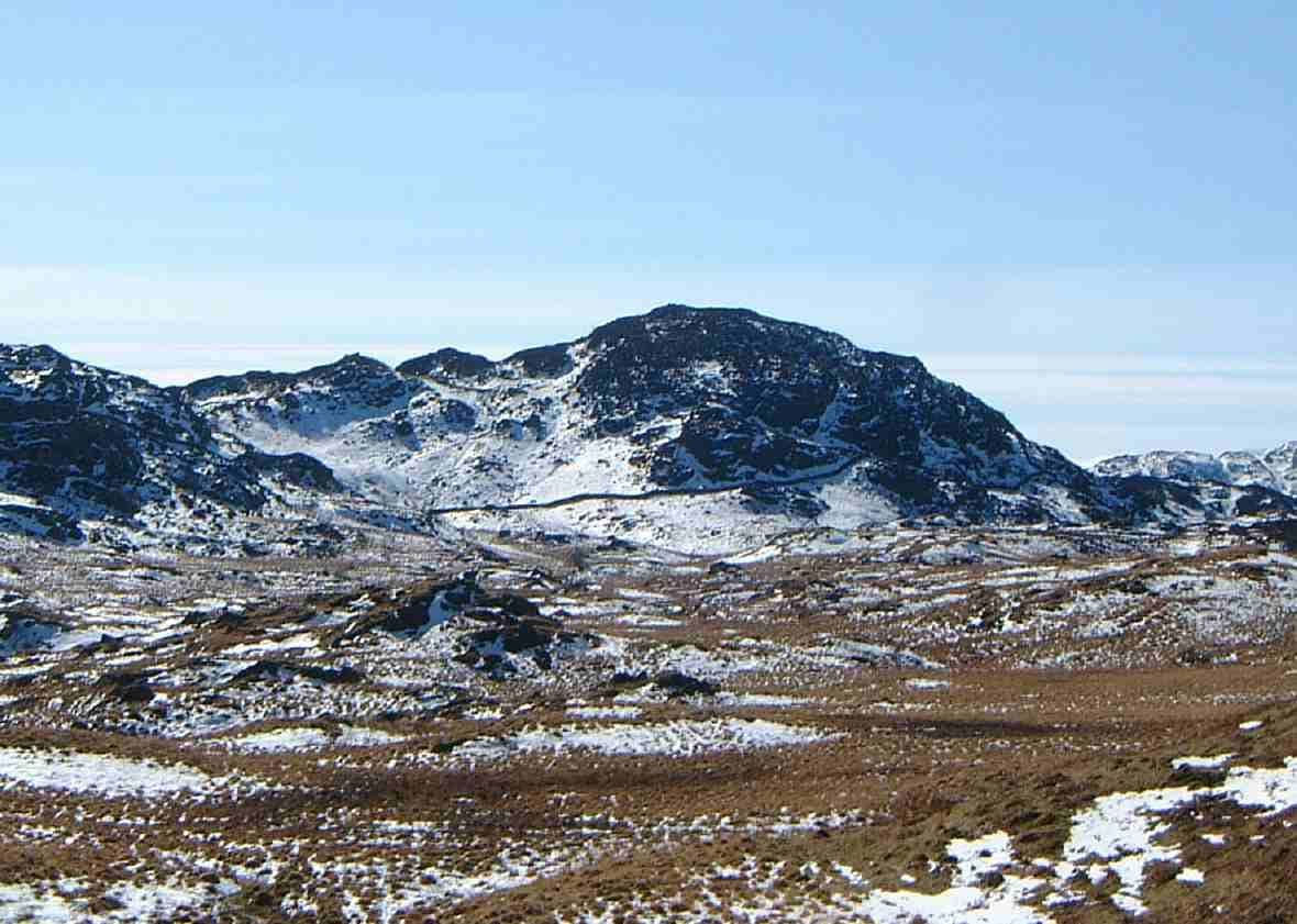
Photo: Mick Knapton via Wikimedia Commons
About Great Crag
A low, rocky Central Fells summit threaded by heather and little tarns. Routes from Watendlath or Rosthwaite are short but characterful, with peeps to High Raise and the Borrowdale tops. A fine add‑on to a valley day.
Dock Tarn lies about half a kilometre south east of the summit in a hollow of heather and rock, and most walkers call in there on the way up or down.
Stonethwaite, Watendlath and Rosthwaite are all starts. At Stonethwaite, parking is limited to the verges of the approach road, and a pitched path climbs steeply through the woods of Lingy End to Dock Tarn. A short walk north west from the tarn brings you to the top. From Watendlath, take the Dock Tarn path, where signposted diversions now lead round the worst of the bog. From Rosthwaite, follow the bridleway towards Watendlath, then head south over boggy moorland that gets firmer and rockier as you climb.
It is a short ascent from every side, but the ground is rough, with squelchy grass lower down and heather and rock near the top. There's no scrambling.
Two tops of almost the same height each carry a cairn, and nobody is sure which is higher. The view is not wide, but it looks down Borrowdale to the higher fells behind, and north over Watendlath Tarn to High Seat and the Skiddaw group.
A mature oak wood clings to the steep Borrowdale slopes below the summit. Grange Fell lies over the wet ground to the north, and the two can be joined in a loop from Watendlath or a longer round from Stonethwaite.
In winter
The moor between Watendlath and Dock Tarn is bog that only firms up in a hard frost. The summit is two cairned knolls in deep heather, so in snow or mist take a bearing from Dock Tarn rather than trusting the trods.
- Family Walk
- Dog Friendly
Sources: Wikipedia: Great Crag, Wainwright Walking: Great Crag and Grange Fell, Walk Lakes: Eagle Crag, Sergeant's Crag and Ullscarf. Updated .
Summit
- OS grid ref
- NY 270 146
- Latitude
- 54.52217° N
- Longitude
- 3.12931° W
- Area
- Central Fells
Walking up Great Crag
The nearest car park on foot is Seatoller NT car park, 4.3 km (2.7 miles) from the summit along mapped paths. Directions to the car park
Route from Seatoller NT car park
- Distance
- 4.3 km
- 2.7 miles, one way
- Ascent
- 359 m
- Total climb to the summit
- Time up
- 1 h 25 min
- Allow 1 to 2 hours
Times use Naismith’s rule, 5 km/h on the flat plus extra time for the climb, with Langmuir’s corrections. It’s a rule of thumb for the way up only, so add stops, weather and the walk back down.
The route follows paths mapped by OpenStreetMap contributors and isn’t a guided line. Check the mountain forecast before you go and carry a map and compass.
Great Crag questions
Is Great Crag a Wainwright?
How high is Great Crag?
Where do you park for Great Crag?
How long does it take to climb Great Crag?
How hard is Great Crag?
Which Wainwrights are near Great Crag?
What is the grid reference for the summit of Great Crag?
Often walked with Great Crag
Fells people usually take in on the same day.
Great Crag in our guides
Wainwrights near Great Crag
Straight-line distance and direction from the summit.
 Grange Fell (Brund Fell)417 m1.7 km N
 Castle Crag290 m2.4 km NW
 Rosthwaite Fell (Bessyboot)551 m2.5 km SW
 Eagle Crag525 m2.6 km S
 High Tove515 m2.6 km NE
 Armboth Fell475 m2.8 km NE
More in the Central Fells
- High Raise [Langdale]762 m
- Harrison Stickle736 m
- Sergeant Man736 m
- Ullscarf726 m
- Thunacar Knott723 m
- Pike o'Stickle708 m
- Pavey Ark700 m
- Loft Crag682 m
- High Seat608 m
- Bleaberry Fell590 m
- Sergeant's Crag571 m
- Blea Rigg556 m
- Steel Fell553 m
- Tarn Crag [Easedale]551 m
- Calf Crag537 m
- Eagle Crag525 m
- High Tove515 m
- Armboth Fell475 m
- Raven Crag461 m
- Gibson Knott420 m
- Grange Fell (Brund Fell)417 m
- Helm Crag405 m
- Silver How395 m
- Walla Crag379 m
- High Rigg357 m
- Loughrigg Fell335 m
Bag Great Crag with Upfell
Reach the summit and capture Great Crag, even with no signal. It goes on your round of the 214 with its own patch.
Coming soon to theApp Store