Northern Fells · Book 5
Binsey
Binsey is a Wainwright, one of the 214 Lake District fells in Alfred Wainwright’s Pictorial Guides. At 447 m (1,467 ft) it is the 192nd highest of the 214 and the 23rd highest in the Northern Fells.
- Height
- 447 m
- 1,467 ft
- Rank
- 192
- of 214
- In area
- 23
- of 24
- Difficulty
- Easy
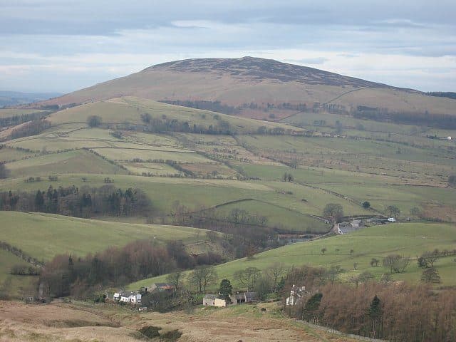
Photo: Ann Bowker
About Binsey
A solitary northern dome with a huge 360° for very modest effort. Short open slopes lead to views from the Solway Firth to the central Lakeland skyline. A superb quick win near Bassenthwaite.
No Wainwright lies further north than Binsey, and it sits apart from the rest of the district. A slight ridge links it to Great Cockup two miles to the south east, but from most directions it looks like an isolated rounded hill of grass and heather, with woodland on its eastern side. Unlike the slate fells nearby, it is built of lavas from the Eycott Volcanic Group. West Crag is its only real outcrop.
There is room for a couple of cars on the minor road beside Binsey Lodge, on the north side. From there a gate leads to a wide grass path that zigzags gently to the top. The out and back walk is about 3 km with 190 metres of climbing, and there is no scrambling or awkward ground. Other ways up start from a lane off the A591 north of Bewaldeth and from High Ireby.
The summit has a trig point, a cairn and several stone windshelters. The highest point is an ancient burial mound, and some of its stones have been rebuilt into shelters.
People come for the view. With nothing close by, Binsey looks straight across at Skiddaw, Ullock Pike and Longside Edge, and across the Whinlatter hills towards Buttermere. North and west you look over the coastal plain and the Solway Firth to the hills of Dumfries and Galloway. On a very clear day you can pick out Snaefell on the Isle of Man and even Slieve Donard in Northern Ireland, about 115 miles away. The line from Binsey to Coniston Old Man, about 23.6 miles, is the longest sight line between any two Wainwrights.
In winter
Binsey stands on its own with nothing to break a north or west wind, but the path is grass all the way and there are no crags on the walking route. It is a good choice for a short winter day when the higher fells are in cloud or too icy.
- Great Views
- Dog Friendly
Sources: Wikipedia: Binsey, Cumbria, Walk Lakes: Binsey. Updated .
Summit
- OS grid ref
- NY 225 355
- Latitude
- 54.70878° N
- Longitude
- 3.20416° W
- Area
- Northern Fells
Walking up Binsey
The nearest car park on foot is Sun Inn Parking, 4.7 km (2.9 miles) from the summit along mapped paths. Directions to the car park
Route from Sun Inn Parking
- Distance
- 4.7 km
- 2.9 miles, one way
- Ascent
- 376 m
- Total climb to the summit
- Time up
- 1 h 31 min
- Allow 1 to 2 hours
Times use Naismith’s rule, 5 km/h on the flat plus extra time for the climb, with Langmuir’s corrections. It’s a rule of thumb for the way up only, so add stops, weather and the walk back down.
The route follows paths mapped by OpenStreetMap contributors and isn’t a guided line. Check the mountain forecast before you go and carry a map and compass.
Binsey questions
Is Binsey a Wainwright?
How high is Binsey?
Where do you park for Binsey?
How long does it take to climb Binsey?
How hard is Binsey?
Which Wainwrights are near Binsey?
What is the grid reference for the summit of Binsey?
Often walked with Binsey
Fells people usually take in on the same day.
Binsey in our guides
- Dog-friendly Wainwrights: fells, leads and livestock
- Doing the Wainwrights together: couples, clubs and dogs
- The easiest Wainwrights: where to start
- Wainwrights for beginners: a first-timer's guide
- Wainwrights with the best views
- Where people finish the Wainwrights: what the two completion registers show
Wainwrights near Binsey
Straight-line distance and direction from the summit.
 Longlands Fell483 m5.1 km E
 Great Cockup526 m5.3 km SE
 Meal Fell550 m6.0 km E
 Bakestall673 m6.2 km SE
 Brae Fell586 m6.4 km E
 Sale Fell359 m6.6 km SW
More in the Northern Fells
- Skiddaw931 m
- Blencathra868 m
- Skiddaw Little Man865 m
- Carl Side746 m
- Long Side734 m
- Lonscale Fell715 m
- Knott710 m
- Bowscale Fell702 m
- Great Calva690 m
- Ullock Pike690 m
- Bannerdale Crags683 m
- Bakestall673 m
- Carrock Fell663 m
- High Pike [Caldbeck]658 m
- Great Sca Fell651 m
- Mungrisdale Common633 m
- Brae Fell586 m
- Meal Fell550 m
- Great Cockup526 m
- Souther Fell522 m
- Dodd502 m
- Longlands Fell483 m
- Latrigg368 m
Bag Binsey with Upfell
Reach the summit and capture Binsey, even with no signal. It goes on your round of the 214 with its own patch.
Coming soon to theApp Store