Northern Fells · Book 5
Bannerdale Crags
Bannerdale Crags is a Wainwright, one of the 214 Lake District fells in Alfred Wainwright’s Pictorial Guides. At 683 m (2,241 ft) it is the 97th highest of the 214 and the 11th highest in the Northern Fells.
- Height
- 683 m
- 2,241 ft
- Rank
- 97
- of 214
- In area
- 11
- of 24
- Difficulty
- Moderate
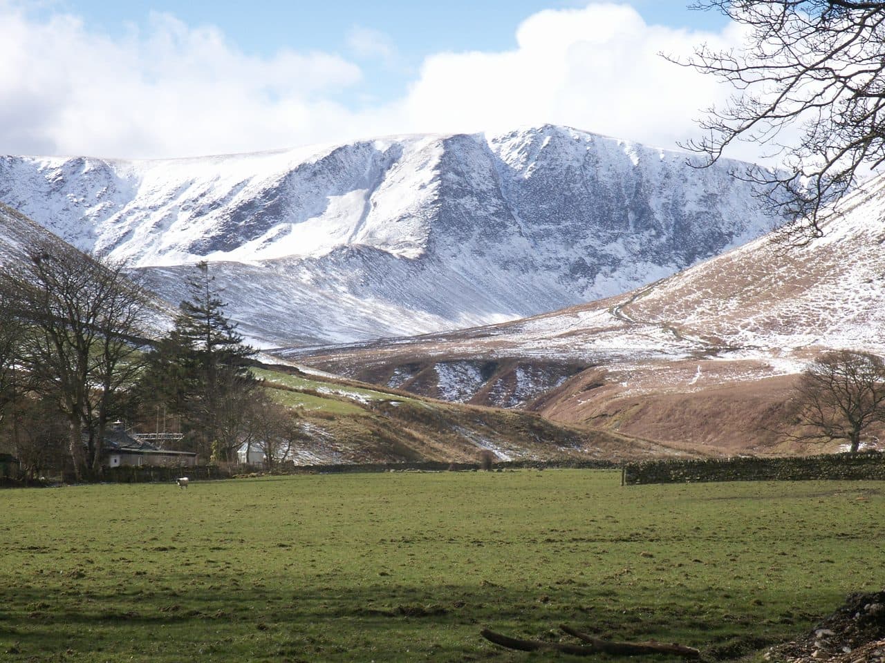
Photo: Bobble Hat via Wikimedia Commons
About Bannerdale Crags
Edgy northern ridges and a fine clifftop outlook into Bannerdale. Good paths with a bit of drama near the rim. Often combined with Bowscale Fell or Blencathra’s outliers.
Seen from Mungrisdale, the fell is a curving line of crags almost a mile long that falls as much as 600 feet into the valley of Bannerdale Beck. From the other side you would hardly notice it: the summit is smooth grass, one step on the ridge that runs north from Blencathra's Atkinson Pike.
Mungrisdale village is the usual base. There is no big car park, but the Recreation Rooms and the lay-by near the telephone box both take cars, with an honesty box. From the village a track goes west up the Glenderamackin. Where Bannerdale Beck joins, you can climb the spur that runs up to the summit from the valley. It is a gentle scramble, and the best line on the fell. The easier choice carries on up the valley and climbs the broad col between Bannerdale Crags and Bowscale Fell, so the two fells go together naturally. From Scales, on the A66, you cross Mousthwaite Comb to the Glenderamackin and come up White Horse Bent at the southern end.
The Skiddaw Slate here breaks down into grass and scree. Paths along the tops are grassy and can be wet, and the valley path from Mungrisdale turns into a stream after heavy rain.
A small cairn of flat stones marks the top, and a second pile nearby is the remains of a shepherd's shelter. You look across to Blencathra, and on a clear day you see as far south as the Coniston fells.
Mines
The ruins in Bannerdale belong to a lead mine, busiest in the second half of the 1800s, on east to west veins of galena and blende. There was also a trial for graphite, without much luck.
In winter
Snow builds overhangs along the rim of the crags above Bannerdale, where the drop is up to 600 feet, so keep well back from the edge. The east spur, a gentle scramble in summer, is a different proposition when its rock steps are iced.
- Dog Friendly
- Ridge Walk
- Great Views
Sources: Wikipedia: Bannerdale Crags, Walk Lakes: Bowscale Fell, Walking Englishman: Bowscale Fell and Bannerdale Crags from Mungrisdale. Updated .
Summit
- OS grid ref
- NY 336 290
- Latitude
- 54.65239° N
- Longitude
- 3.03045° W
- Area
- Northern Fells
Walking up Bannerdale Crags
The nearest car park on foot is Threlkeld Car Park, 5.2 km (3.2 miles) from the summit along mapped paths. Directions to the car park
Route from Threlkeld Car Park
- Distance
- 5.2 km
- 3.2 miles, one way
- Ascent
- 741 m
- Total climb to the summit
- Time up
- 2 h 11 min
- Allow 1 to 3 hours
Times use Naismith’s rule, 5 km/h on the flat plus extra time for the climb, with Langmuir’s corrections. It’s a rule of thumb for the way up only, so add stops, weather and the walk back down.
The route follows paths mapped by OpenStreetMap contributors and isn’t a guided line. Check the mountain forecast before you go and carry a map and compass.
Bannerdale Crags questions
Is Bannerdale Crags a Wainwright?
How high is Bannerdale Crags?
Where do you park for Bannerdale Crags?
How long does it take to climb Bannerdale Crags?
How hard is Bannerdale Crags?
Which Wainwrights are near Bannerdale Crags?
What is the grid reference for the summit of Bannerdale Crags?
Often walked with Bannerdale Crags
Fells people usually take in on the same day.
Wainwrights near Bannerdale Crags
Straight-line distance and direction from the summit.
 Bowscale Fell702 m1.5 km N
 Souther Fell522 m1.9 km E
 Blencathra868 m1.9 km SW
 Mungrisdale Common633 m2.6 km W
 Carrock Fell663 m4.6 km N
 Great Calva690 m5.0 km NW
More in the Northern Fells
- Skiddaw931 m
- Blencathra868 m
- Skiddaw Little Man865 m
- Carl Side746 m
- Long Side734 m
- Lonscale Fell715 m
- Knott710 m
- Bowscale Fell702 m
- Great Calva690 m
- Ullock Pike690 m
- Bakestall673 m
- Carrock Fell663 m
- High Pike [Caldbeck]658 m
- Great Sca Fell651 m
- Mungrisdale Common633 m
- Brae Fell586 m
- Meal Fell550 m
- Great Cockup526 m
- Souther Fell522 m
- Dodd502 m
- Longlands Fell483 m
- Binsey447 m
- Latrigg368 m
Bag Bannerdale Crags with Upfell
Reach the summit and capture Bannerdale Crags, even with no signal. It goes on your round of the 214 with its own patch.
Coming soon to theApp Store