Northern Fells · Book 5
Ullock Pike
Ullock Pike is a Wainwright, one of the 214 Lake District fells in Alfred Wainwright’s Pictorial Guides. At 690 m (2,264 ft) it is the joint 95th highest of the 214 and the joint 9th highest in the Northern Fells.
- Height
- 690 m
- 2,264 ft
- Rank
- =95
- of 214
- In area
- =9
- of 24
- Difficulty
- Moderate
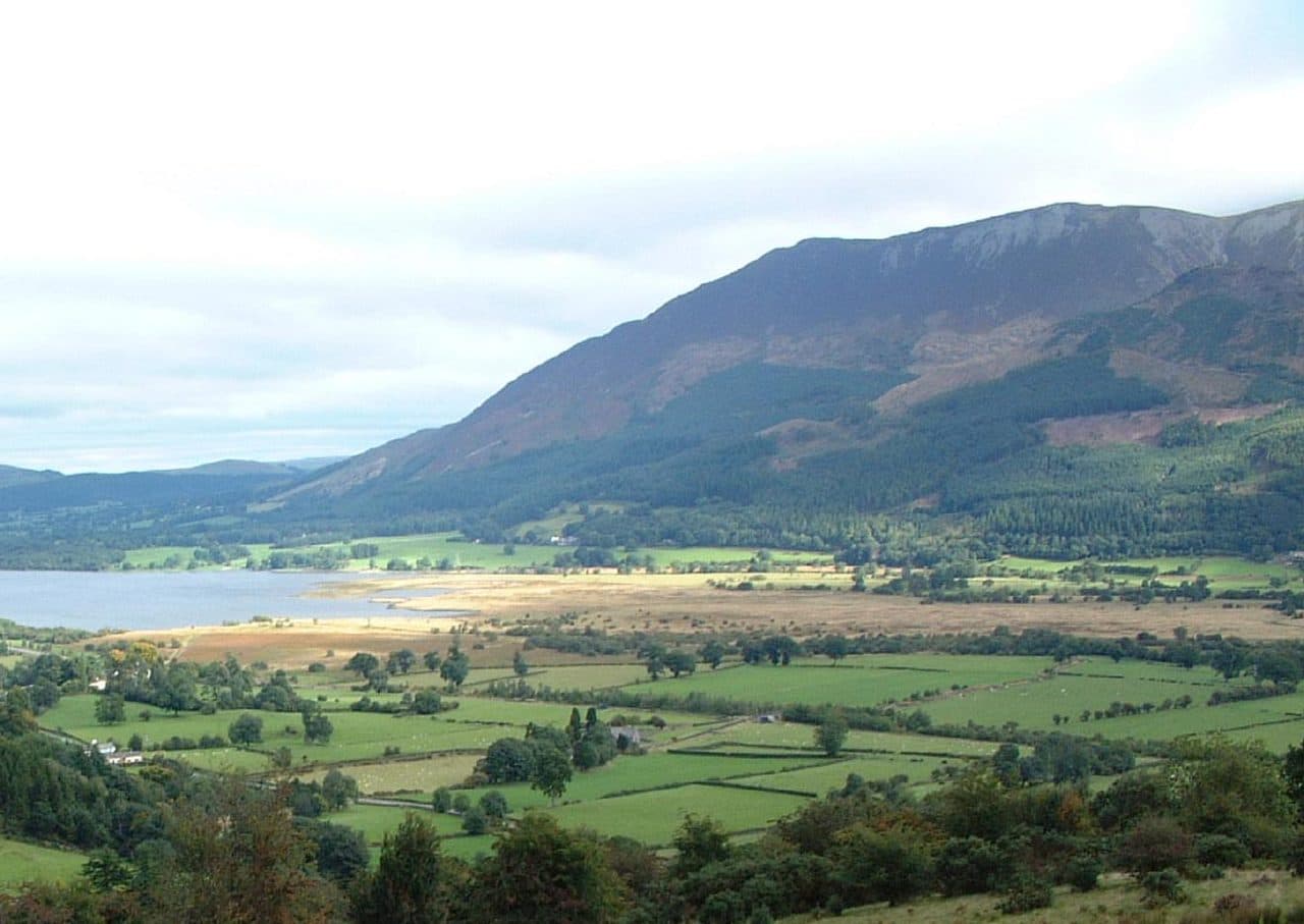
Photo: Mick Knapton via Wikimedia Commons
About Ullock Pike
A slender peak at the north end of Longside Edge, dropping steeply into Southerndale on one side and through woods to Bassenthwaite Lake on the other. Usually walked with Long Side and Carl Side.
From the north, Ullock Pike looks like a sharp, slender peak. From most other places it is just a bump at the end of Longside Edge. Its eastern side falls steeply into the quiet valley of Southerndale, and its western slopes drop through woods to Bassenthwaite Lake. It rises only 14 metres above the col to Long Side, so Wainwright gave it its own chapter mostly for its shape and its view.
The ridge climbs from the A591. The Ravenstone Hotel has a bus stop and a little parking, and there is another start on the minor road towards Orthwaite, at about NY 236 310. Both go straight up the north ridge, which has a false top before the real one. From the Old Sawmill tearoom pay car park, 1.5 km south, marker posts lead through Dodd Wood to the ridge, where you turn right for the summit. The popular round then follows Longside Edge over Long Side to Carl Side and drops back to the car park by Long Doors, 10 km with 700 metres of climbing.
It is grass and Skiddaw Slate, steep and loose in places, and Walk Lakes rates it hands on rock at times.
The summit is a small patch of heather with a cairn. Skiddaw cuts off the view east, but the rest reaches well beyond Bassenthwaite Lake.
Ulvelaik
The name comes from Old Norse and means the place where wolves play. Records from the 1200s call it Ulvelaik. About 1.5 km north, a knoll called Watches has odd outcrops of igneous rock among the slate, which at first look like a stone circle or an old quarry.
In winter
The north ridge and Longside Edge face straight into a westerly off Bassenthwaite Lake. Walk Lakes grades the round as steep with loose scree and some hands on rock, all of it harder under snow or ice.
- Dog Friendly
- Ridge Walk
Sources: Wikipedia: Ullock Pike, Walk Lakes: Ullock Pike, Longside Edge, Carl Side. Updated .
Summit
- OS grid ref
- NY 244 287
- Latitude
- 54.64824° N
- Longitude
- 3.17245° W
- Area
- Northern Fells
Walking up Ullock Pike
The nearest car park on foot is Dodd Wood car park, 3.8 km (2.4 miles) from the summit along mapped paths. Directions to the car park
Route from Dodd Wood car park
- Distance
- 3.8 km
- 2.4 miles, one way
- Ascent
- 595 m
- Total climb to the summit
- Time up
- 1 h 41 min
- Allow 1 to 3 hours
Times use Naismith’s rule, 5 km/h on the flat plus extra time for the climb, with Langmuir’s corrections. It’s a rule of thumb for the way up only, so add stops, weather and the walk back down.
The route follows paths mapped by OpenStreetMap contributors and isn’t a guided line. Check the mountain forecast before you go and carry a map and compass.
Ullock Pike questions
Is Ullock Pike a Wainwright?
How high is Ullock Pike?
Where do you park for Ullock Pike?
How long does it take to climb Ullock Pike?
How hard is Ullock Pike?
Which Wainwrights are near Ullock Pike?
What is the grid reference for the summit of Ullock Pike?
Often walked with Ullock Pike
Fells people usually take in on the same day.
Wainwrights near Ullock Pike
Straight-line distance and direction from the summit.
 Long Side734 m0.5 km SE
 Carl Side746 m1.2 km SE
 Dodd502 m1.4 km S
 Skiddaw931 m1.6 km E
 Skiddaw Little Man865 m2.4 km E
 Bakestall673 m3.0 km NE
More in the Northern Fells
- Skiddaw931 m
- Blencathra868 m
- Skiddaw Little Man865 m
- Carl Side746 m
- Long Side734 m
- Lonscale Fell715 m
- Knott710 m
- Bowscale Fell702 m
- Great Calva690 m
- Bannerdale Crags683 m
- Bakestall673 m
- Carrock Fell663 m
- High Pike [Caldbeck]658 m
- Great Sca Fell651 m
- Mungrisdale Common633 m
- Brae Fell586 m
- Meal Fell550 m
- Great Cockup526 m
- Souther Fell522 m
- Dodd502 m
- Longlands Fell483 m
- Binsey447 m
- Latrigg368 m
Bag Ullock Pike with Upfell
Reach the summit and capture Ullock Pike, even with no signal. It goes on your round of the 214 with its own patch.
Coming soon to theApp Store