Northern Fells · Book 5
Knott
Knott is a Wainwright, one of the 214 Lake District fells in Alfred Wainwright’s Pictorial Guides. At 710 m (2,329 ft) it is the 82nd highest of the 214 and the 7th highest in the Northern Fells.
- Height
- 710 m
- 2,329 ft
- Rank
- 82
- of 214
- In area
- 7
- of 24
- Difficulty
- Moderate
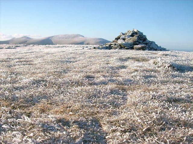
Photo: Dreamer via Geograph, CC BY-SA 2.0
About Knott
The broad high point of the moorland behind Skiddaw, with a wide view over the Northern Fells. The heathery approaches are long and remote. Keep it for a clear day, when you can see Skiddaw and Blencathra and navigate easily.
At the centre of the fells back o' Skiddaw sits Knott, a long whaleback of grass running about 3 miles east to west. Burn Tod sits at the western end, Frozen Fell runs alongside to the north and Coomb Height ends it in the east. Streams have cut deep ravines into the slopes, and the yellow and red soil they expose shows from a long way off. Few people come this way.
No road comes close. The Walk Lakes route leaves from the end of the Mosedale road, where a few cars fit on the verge before the Grainsgill Beck bridge. It climbs Great Calva first by Wiley Gill, then crosses a stile and a stretch of moss and tussocks to Knott's domed top. The way down goes east towards Coomb Height, avoiding peat hags, and follows Grainsgill Beck past Lingy Hut and the old mine to the road. It is 12 km and rated wet and boggy. Other walkers come from Orthwaite by the bridleway up Hause Gill, from Longlands over the Uldale Fells, or from Mungrisdale.
The ground is grass, moss and heather with no rock to climb. Paths are faint, and Walk Lakes says good visibility is required to see the way on.
A plain pile of stones marks the summit. Skiddaw and Blencathra fill much of the view south, but Thirlmere and the Scafells show between them. North you see the Solway Firth and the hills of south west Scotland.
Tungsten
The Harding vein under Knott fed Carrock Mine, the only tungsten mine in Britain outside Cornwall and Devon, which worked on and off until the 1980s. The vein beneath Knott is worked out, and the old levels at Coomb Height were later used to hold sludge from the ore processing.
In winter
Knott is a big, featureless dome, and the paths that cross it are faint and boggy, so snow or cloud leaves you navigating by compass. Every approach is long and remote, so plan the day around the light.
- Great Views
- Quiet & Remote
- Dog Friendly
Sources: Wikipedia: Knott, Caldbeck, Walk Lakes: Great Calva and Knott from Mosedale. Updated .
Summit
- OS grid ref
- NY 296 329
- Latitude
- 54.68696° N
- Longitude
- 3.09330° W
- Area
- Northern Fells
Walking up Knott
The nearest car park on foot is Sun Inn Parking, 8.4 km (5.3 miles) from the summit along mapped paths. Directions to the car park
Route from Sun Inn Parking
- Distance
- 8.4 km
- 5.3 miles, one way
- Ascent
- 740 m
- Total climb to the summit
- Time up
- 2 h 49 min
- Allow 2 to 4 hours
Times use Naismith’s rule, 5 km/h on the flat plus extra time for the climb, with Langmuir’s corrections. It’s a rule of thumb for the way up only, so add stops, weather and the walk back down.
The route follows paths mapped by OpenStreetMap contributors and isn’t a guided line. Check the mountain forecast before you go and carry a map and compass.
Knott questions
Is Knott a Wainwright?
How high is Knott?
Where do you park for Knott?
How long does it take to climb Knott?
How hard is Knott?
Which Wainwrights are near Knott?
What is the grid reference for the summit of Knott?
Often walked with Knott
Fells people usually take in on the same day.
Knott in our guides
Wainwrights near Knott
Straight-line distance and direction from the summit.
 Great Sca Fell651 m1.0 km NW
 Meal Fell550 m1.5 km NW
 Great Calva690 m1.9 km S
 Brae Fell586 m2.3 km N
 Great Cockup526 m2.3 km W
 High Pike [Caldbeck]658 m3.0 km NE
More in the Northern Fells
- Skiddaw931 m
- Blencathra868 m
- Skiddaw Little Man865 m
- Carl Side746 m
- Long Side734 m
- Lonscale Fell715 m
- Bowscale Fell702 m
- Great Calva690 m
- Ullock Pike690 m
- Bannerdale Crags683 m
- Bakestall673 m
- Carrock Fell663 m
- High Pike [Caldbeck]658 m
- Great Sca Fell651 m
- Mungrisdale Common633 m
- Brae Fell586 m
- Meal Fell550 m
- Great Cockup526 m
- Souther Fell522 m
- Dodd502 m
- Longlands Fell483 m
- Binsey447 m
- Latrigg368 m
Bag Knott with Upfell
Reach the summit and capture Knott, even with no signal. It goes on your round of the 214 with its own patch.
Coming soon to theApp Store