Northern Fells · Book 5
Blencathra
Blencathra is a Wainwright, one of the 214 Lake District fells in Alfred Wainwright’s Pictorial Guides. At 868 m (2,848 ft) it is the 14th highest of the 214 and the 2nd highest in the Northern Fells.
- Height
- 868 m
- 2,848 ft
- Rank
- 14
- of 214
- In area
- 2
- of 24
- Difficulty
- Difficult
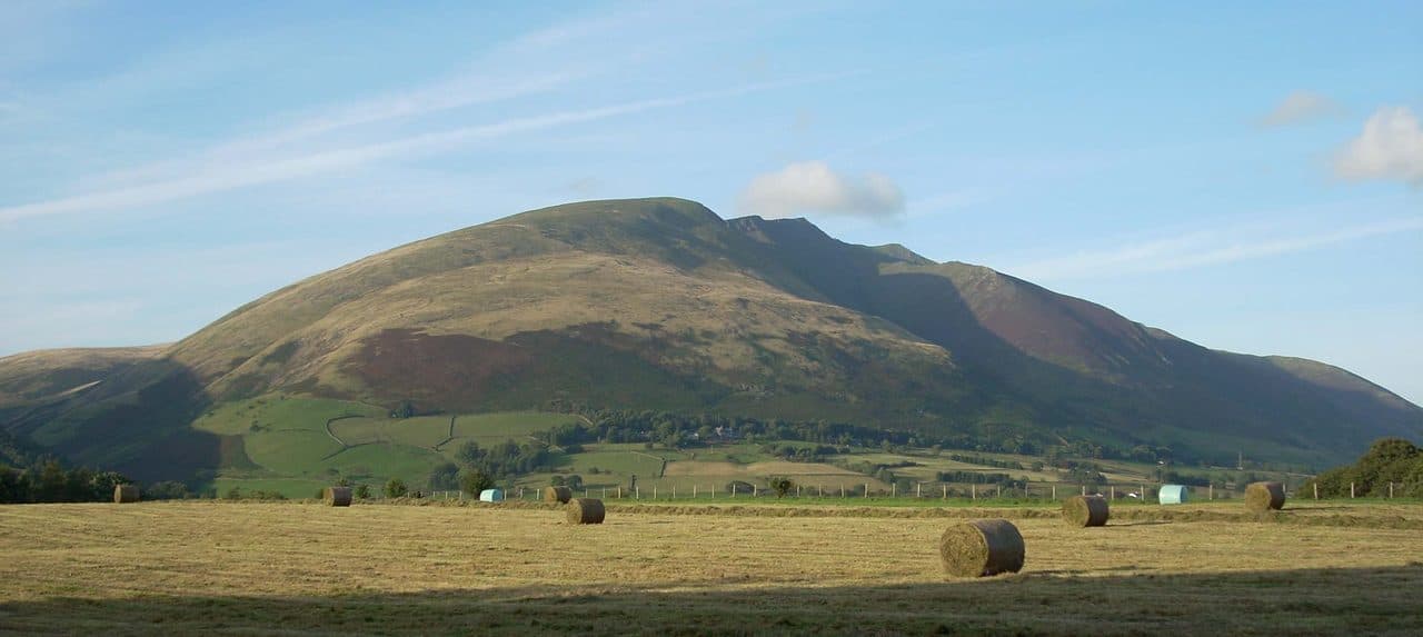
Photo: Rob Bendall
About Blencathra
A striking northern mountain with a crown of ridges, most famously Sharp Edge. The Hall's Fell ridge gives a superb direct line to the true summit, with hands-on interest and a fine sense of height over the Vale of Keswick. Other routes avoid the exposure if needed. A fell with plenty of drama and views that reach the Pennines.
Sharp Edge is the route everyone has heard of, and it starts at Scales on the A66, not in Threlkeld. There is a small free car park beside the White Horse Inn and a lay-by on the main road. Buses do not stop at Scales. The X4 and X5 between Keswick and Penrith stop at the Horse and Farrier in Threlkeld, about two miles west.
Sharp Edge
From Scales a path curls round Scales Fell and up the Glenderamackin to Scales Tarn, a small round tarn under the crags, and Sharp Edge rises straight out of it. The crest runs for about 300 metres and in places is barely a metre wide. Two thirds of the way along comes the awkward move, a sloping slab of smooth rock that plenty of people cross sitting down. Then you climb steep rock up Foule Crag onto the summit plateau. This is scrambling, and once you are on the edge there is no easy way off.
Threlkeld sits under the south face, where a row of ridges climbs to the top. Hall's Fell finishes at the summit on a rocky crest with easy scrambling. Scales Fell and the long grass slope of Blease Fell need no hands.
The top, Hallsfell Top, has a concrete trig ring on the lip of the south face. Below you are the Vale of Keswick and the central fells, and on exceptional days you can pick out the Mourne Mountains in County Down. The other name, Saddleback, comes from the dip in the skyline seen from the Penrith side. On the saddle north of the summit ridge a large cross of white stones lies flat in the grass. Harold Robinson of Threlkeld made it bigger after the Second World War.
In winter
Under snow and ice Sharp Edge is beyond most walkers, and its sloping slabs are treacherous even when they are only wet, so leave it alone unless you have an axe, crampons and the experience to use them. Hall's Fell also ices along its crest. On a short winter day Scales Fell and Blease Fell are the safer ways up and down.
- Ridge Walk
- Scramble
- Great Views
- Popular
- Potentially Dangerous
Sources: Wikipedia: Blencathra, Anywhere We Roam: Blencathra via Sharp Edge, Walk Lakes: A Walker's Blencathra. Updated .
Summit
- OS grid ref
- NY 323 277
- Latitude
- 54.63993° N
- Longitude
- 3.04975° W
- Area
- Northern Fells
Walking up Blencathra
The nearest car park on foot is Threlkeld Car Park, 2.7 km (1.7 miles) from the summit along mapped paths. Directions to the car park
Route from Threlkeld Car Park
- Distance
- 2.7 km
- 1.7 miles, one way
- Ascent
- 682 m
- Total climb to the summit
- Time up
- 1 h 37 min
- Allow 1 to 3 hours
Times use Naismith’s rule, 5 km/h on the flat plus extra time for the climb, with Langmuir’s corrections. It’s a rule of thumb for the way up only, so add stops, weather and the walk back down.
The route follows paths mapped by OpenStreetMap contributors and isn’t a guided line. Check the mountain forecast before you go and carry a map and compass.
Blencathra questions
Is Blencathra a Wainwright?
How high is Blencathra?
Where do you park for Blencathra?
How long does it take to climb Blencathra?
How hard is Blencathra?
Which Wainwrights are near Blencathra?
What is the grid reference for the summit of Blencathra?
Often walked with Blencathra
Fells people usually take in on the same day.
Blencathra in our guides
Wainwrights near Blencathra
Straight-line distance and direction from the summit.
 Bannerdale Crags683 m1.9 km NE
 Mungrisdale Common633 m2.0 km NW
 Bowscale Fell702 m3.0 km N
 Souther Fell522 m3.4 km NE
 Lonscale Fell715 m3.8 km W
 Great Calva690 m4.8 km NW
More in the Northern Fells
- Skiddaw931 m
- Skiddaw Little Man865 m
- Carl Side746 m
- Long Side734 m
- Lonscale Fell715 m
- Knott710 m
- Bowscale Fell702 m
- Great Calva690 m
- Ullock Pike690 m
- Bannerdale Crags683 m
- Bakestall673 m
- Carrock Fell663 m
- High Pike [Caldbeck]658 m
- Great Sca Fell651 m
- Mungrisdale Common633 m
- Brae Fell586 m
- Meal Fell550 m
- Great Cockup526 m
- Souther Fell522 m
- Dodd502 m
- Longlands Fell483 m
- Binsey447 m
- Latrigg368 m
Bag Blencathra with Upfell
Reach the summit and capture Blencathra, even with no signal. It goes on your round of the 214 with its own patch.
Coming soon to theApp Store