Northern Fells · Book 5
Lonscale Fell
Lonscale Fell is a Wainwright, one of the 214 Lake District fells in Alfred Wainwright’s Pictorial Guides. At 715 m (2,346 ft) it is the joint 79th highest of the 214 and the 6th highest in the Northern Fells.
- Height
- 715 m
- 2,346 ft
- Rank
- =79
- of 214
- In area
- 6
- of 24
- Difficulty
- Moderate
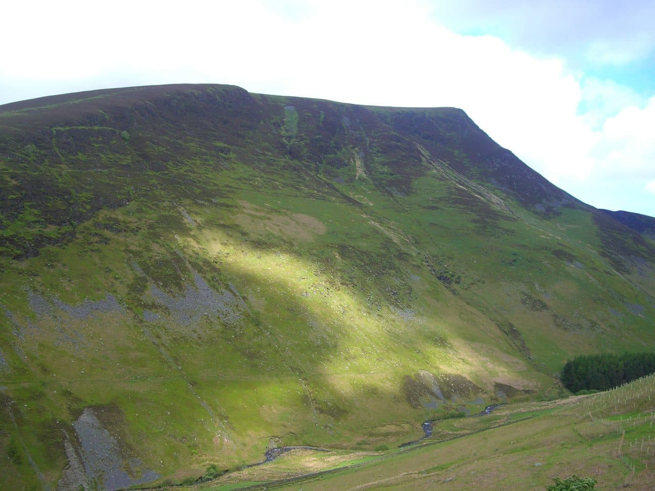
Photo: Mick Knapton via Wikimedia Commons
About Lonscale Fell
A shoulder at the eastern end of the Skiddaw massif, with crags above the Glenderaterra. The view south takes in Derwentwater, Thirlmere and the central fells.
Skiddaw's range ends to the east with Lonscale Fell. From Keswick its gentle southern slopes of sheep pasture look unremarkable, but the eastern side is a line of crags about a mile long above Glenderaterra Beck, which is unusual for the Skiddaw fells. A pointed second top, Lonscale Pike, stands at the end of it.
Start from the car park at the end of Gale Road, behind Latrigg. You can go up the southern slopes directly, or take the Skiddaw path to Flag Pots and turn right along the fence. The better walk follows the Cumbria Way round the fell on a terraced path into the Glenderaterra valley, then climbs Burnt Horse Ridge, which falls northeast from the top. It is short and very steep on grass, with stiles along the ridge fence that have dog gates. Cross to the summit, visit the east top, then come down to Flag Pots beside Whit Beck and back on the Skiddaw path. Walk Lakes makes this 10 km with 650 metres of climbing. From Skiddaw House you can also come up Burnt Horse or scramble a buttress to Lonscale Pike.
A small cairn marks the highest point. Look south for the best of it: Derwentwater, Thirlmere and the high fells in the middle of the district. The view north over Skiddaw Forest is closer and duller.
Below the crags
Miners dug for lead, copper and baryte in the Glenderaterra in the 1800s. The Glenderaterra Mine, later called Brundholme, lasted until 1920. None of them made much money, and old quarries remain below the eastern crags. Since 2012 a fence has protected Jubilee Wood, where the estate is bringing back juniper and oak under Burnt Horse.
In winter
The top of Burnt Horse Ridge is a short, very steep grass slope that is treacherous when frozen. In snow the gentler line is the Skiddaw path to Flag Pots, then along the fence.
- Great Views
- Dog Friendly
Sources: Wikipedia: Lonscale Fell, Walk Lakes: Lonscale Fell via Burnt Horse Ridge. Updated .
Summit
- OS grid ref
- NY 285 271
- Latitude
- 54.63458° N
- Longitude
- 3.10858° W
- Area
- Northern Fells
Walking up Lonscale Fell
The nearest car park on foot is Crosthwaite Road Car Park, 5.5 km (3.4 miles) from the summit along mapped paths. Directions to the car park
Route from Crosthwaite Road Car Park
- Distance
- 5.5 km
- 3.4 miles, one way
- Ascent
- 660 m
- Total climb to the summit
- Time up
- 2 h 7 min
- Allow 1 to 3 hours
Times use Naismith’s rule, 5 km/h on the flat plus extra time for the climb, with Langmuir’s corrections. It’s a rule of thumb for the way up only, so add stops, weather and the walk back down.
The route follows paths mapped by OpenStreetMap contributors and isn’t a guided line. This car park was picked automatically and hasn’t been checked by hand yet, so compare it with a map. Check the mountain forecast before you go and carry a map and compass.
Lonscale Fell questions
Is Lonscale Fell a Wainwright?
How high is Lonscale Fell?
Where do you park for Lonscale Fell?
How long does it take to climb Lonscale Fell?
How hard is Lonscale Fell?
Which Wainwrights are near Lonscale Fell?
What is the grid reference for the summit of Lonscale Fell?
Often walked with Lonscale Fell
Fells people usually take in on the same day.
Lonscale Fell in our guides
Wainwrights near Lonscale Fell
Straight-line distance and direction from the summit.
 Skiddaw Little Man865 m2.0 km W
 Latrigg368 m2.5 km S
 Skiddaw931 m3.1 km NW
 Carl Side746 m3.2 km W
 Mungrisdale Common633 m3.2 km NE
 Blencathra868 m3.8 km E
More in the Northern Fells
- Skiddaw931 m
- Blencathra868 m
- Skiddaw Little Man865 m
- Carl Side746 m
- Long Side734 m
- Knott710 m
- Bowscale Fell702 m
- Great Calva690 m
- Ullock Pike690 m
- Bannerdale Crags683 m
- Bakestall673 m
- Carrock Fell663 m
- High Pike [Caldbeck]658 m
- Great Sca Fell651 m
- Mungrisdale Common633 m
- Brae Fell586 m
- Meal Fell550 m
- Great Cockup526 m
- Souther Fell522 m
- Dodd502 m
- Longlands Fell483 m
- Binsey447 m
- Latrigg368 m
Bag Lonscale Fell with Upfell
Reach the summit and capture Lonscale Fell, even with no signal. It goes on your round of the 214 with its own patch.
Coming soon to theApp Store