North Western Fells · Book 6
Castle Crag
Castle Crag is a Wainwright, one of the 214 Lake District fells in Alfred Wainwright’s Pictorial Guides. At 290 m (951 ft) it is the lowest of the 214 and the lowest in the North Western Fells.
- Height
- 290 m
- 951 ft
- Rank
- 214
- of 214
- In area
- 29
- of 29
- Difficulty
- Moderate
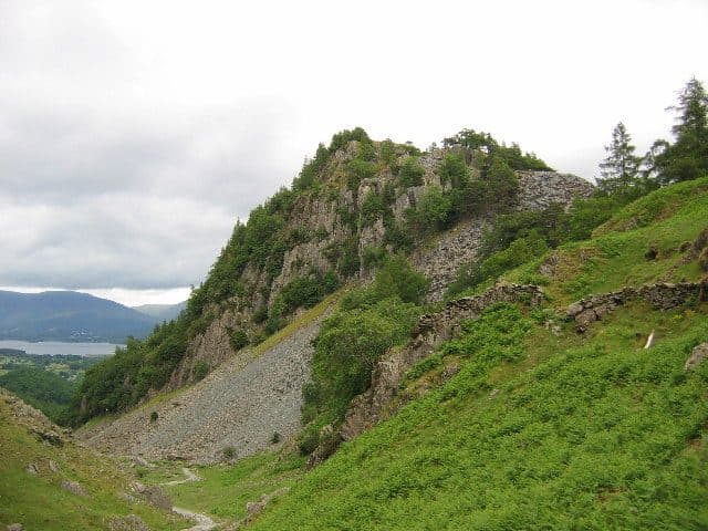
Photo: Stephen Horncastle via Geograph, CC BY-SA 2.0
About Castle Crag
The smallest Wainwright but full of character, guarding the narrows of Borrowdale. A steep slate path zigzags up to a summit rock that carries the Borrowdale war memorial, with a mighty view down Derwentwater. Perfect when time is short but you still want a proper summit.
Rosthwaite is the handiest start, with a National Trust pay and display car park, and Grange, a mile or so north, is the other. The 77 and 77A Honister Rambler buses from Keswick stop in both villages and at Seatoller, so you can go up from one and come down to another. From Rosthwaite the path follows the River Derwent north, then climbs into the gap between Castle Crag and the flank of High Spy. From Grange you walk up the riverside track through the woods. The National Trust also waymarks a longer way in from Seatoller.
The climbing only starts near the end. A ladder stile with narrow rungs takes you over a wall, and then the path zigzags up a large tip of green slate spoil left by the quarrymen. It looks loose but is stable, and it needs care rather than hands. At the top is the old quarry, with thin slabs stood on end all over the ground, and a short rise brings you to the summit.
The highest rock carries Borrowdale's war memorial to local men killed in the First World War. The top is thought to have been a hill fort, though quarrying has taken away its western side. You can see north down Derwentwater to Skiddaw and south to Great Gable and the Scafells. It is the only Wainwright under 1,000 feet.
On the east side, the quarry at High Hows has two caves. Millican Dalton, who called himself the Professor of Adventure, spent his summers in one of them from the 1920s until he died in 1947. A National Trust sign marks it, and a path from the Rosthwaite side passes close by.
In winter
Castle Crag is low enough to stay clear when the tops around it are white, so it suits a short winter day. The zigzags up the slate spoil get greasy in rain and slick with frost, though, and they are trickier coming down than going up.
- Great Views
- Popular
- Family Walk
- Dog Friendly
Sources: Wikipedia: Castle Crag, Walk Lakes: Castle Crag, Borrowdale. Updated .
Summit
- OS grid ref
- NY 249 159
- Latitude
- 54.53317° N
- Longitude
- 3.16159° W
Walking up Castle Crag
The nearest car park on foot is Seatoller NT car park, 2.8 km (1.8 miles) from the summit along mapped paths. Directions to the car park
Route from Seatoller NT car park
- Distance
- 2.8 km
- 1.8 miles, one way
- Ascent
- 230 m
- Total climb to the summit
- Time up
- 53 min
- Allow 1 to 2 hours
Times use Naismith’s rule, 5 km/h on the flat plus extra time for the climb, with Langmuir’s corrections. It’s a rule of thumb for the way up only, so add stops, weather and the walk back down.
The route follows paths mapped by OpenStreetMap contributors and isn’t a guided line. This car park was picked automatically and hasn’t been checked by hand yet, so compare it with a map. Check the mountain forecast before you go and carry a map and compass.
Castle Crag questions
Is Castle Crag a Wainwright?
How high is Castle Crag?
Where do you park for Castle Crag?
How long does it take to climb Castle Crag?
How hard is Castle Crag?
Which Wainwrights are near Castle Crag?
What is the grid reference for the summit of Castle Crag?
Often walked with Castle Crag
Fells people usually take in on the same day.
Castle Crag in our guides
- Doing the Wainwrights together: couples, clubs and dogs
- Family-friendly Wainwrights: loops, lakes and picnic tops
- The easiest Wainwrights: where to start
- Wainwrights by bus: the Lake District without a car
- Wainwrights from Borrowdale
- Wainwrights from Keswick
- Wainwrights to avoid in bad weather, and where to go instead
- Wainwrights with the best views
- Where people finish the Wainwrights: what the two completion registers show
- Winter Wainwrights: fells you can still reach when the passes shut
Wainwrights near Castle Crag
Straight-line distance and direction from the summit.
 High Spy653 m1.5 km W
 Grange Fell (Brund Fell)417 m1.6 km E
 Great Crag449 m2.4 km SE
 Maiden Moor575 m2.6 km NW
 Dale Head753 m2.7 km W
 Hindscarth727 m3.4 km W
More in the North Western Fells
- Grasmoor852 m
- Eel Crag (Crag Hill)839 m
- Grisedale Pike791 m
- Wandope774 m
- Sail773 m
- Hopegill Head770 m
- Dale Head753 m
- Robinson737 m
- Hindscarth727 m
- Whiteside (west top)707 m
- Scar Crags672 m
- Whiteless Pike660 m
- High Spy653 m
- Causey Pike637 m
- Ard Crags581 m
- Maiden Moor575 m
- Outerside568 m
- Knott Rigg556 m
- Lord's Seat552 m
- Whinlatter (Brown How)517 m
- Broom Fell511 m
- Barf469 m
- Barrow455 m
- Graystones452 m
- Catbells451 m
- Ling Fell373 m
- Sale Fell359 m
- Rannerdale Knotts355 m
Bag Castle Crag with Upfell
Reach the summit and capture Castle Crag, even with no signal. It goes on your round of the 214 with its own patch.
Coming soon to theApp Store