North Western Fells · Book 6
Dale Head
Dale Head is a Wainwright, one of the 214 Lake District fells in Alfred Wainwright’s Pictorial Guides. At 753 m (2,470 ft) it is the 63rd highest of the 214 and the 7th highest in the North Western Fells.
- Height
- 753 m
- 2,470 ft
- Rank
- 63
- of 214
- In area
- 7
- of 29
- Difficulty
- Moderate
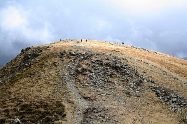
Photo: Steve Partridge via Geograph, CC BY-SA 2.0
About Dale Head
A perfect viewpoint over Borrowdale with a proud summit cairn and coiled ridges to Hindscarth and Robinson. A natural finale or opener to big North Western rounds.
Dale Head stands straight above Honister Pass, and the quickest way up starts there. There is a car park at the top of the pass beside the youth hostel, at about 360m. A path follows a fence line north for roughly 2km to the summit, around 45 to 50 minutes for most walkers. It is steep in places on grass and rock, with no scrambling.
From Newlands the approach is longer and far finer. Park at Chapel Bridge in Little Town, where the farmer takes a small fee. Walk up the valley past old mine workings and a run of waterfalls on the young Newlands Beck to Dalehead Tarn. From the tarn, steps and then a rough, steep path climb to the top. Walk Lakes' loop links Robinson, Hindscarth and Dale Head from Little Town, 14.5km with 850m of ascent. From Borrowdale you can also start at Seatoller or Longthwaite and climb by Launchy Tarn and High Scawdel.
The summit cairn stands on the brink of the northern face. The view straight down the Newlands valley to Skiddaw is the best thing up here, and on a clear day you can pick out every major Lakeland group except the High Street range.
The fell sits where the Skiddaw slates meet the Borrowdale volcanics, and it has been dug into from both sides. Copper came from Dale Head Mine under the northern crags and from Long Work lower down the valley. Honister's slate quarries run into the southern flank. In 1887 work began on a tunnel under the fell to carry slate to Newlands and on to the railway at Keswick, but landowners objected and the scheme was dropped. The youth hostel was once housing for the quarry workers.
In winter
The summit cairn stands right on the edge of the northern crags, so keep well back in snow or mist. The descent towards Dalehead Tarn is loose and steep at the top before the engineered steps start, and both sections are treacherous when icy.
- Great Views
- Family Walk
- Dog Friendly
Sources: Wikipedia: Dale Head, Walk Lakes: Robinson, Hindscarth and Dale Head. Updated .
Summit
- OS grid ref
- NY 223 153
- Latitude
- 54.52727° N
- Longitude
- 3.20194° W
Walking up Dale Head
The nearest car park on foot is Seatoller NT car park, 4.1 km (2.5 miles) from the summit along mapped paths. Directions to the car park
Route from Seatoller NT car park
- Distance
- 4.1 km
- 2.5 miles, one way
- Ascent
- 684 m
- Total climb to the summit
- Time up
- 1 h 52 min
- Allow 1 to 3 hours
Times use Naismith’s rule, 5 km/h on the flat plus extra time for the climb, with Langmuir’s corrections. It’s a rule of thumb for the way up only, so add stops, weather and the walk back down.
The route follows paths mapped by OpenStreetMap contributors and isn’t a guided line. Check the mountain forecast before you go and carry a map and compass.
Dale Head questions
Is Dale Head a Wainwright?
How high is Dale Head?
Where do you park for Dale Head?
How long does it take to climb Dale Head?
How hard is Dale Head?
Which Wainwrights are near Dale Head?
What is the grid reference for the summit of Dale Head?
Often walked with Dale Head
Fells people usually take in on the same day.
Dale Head in our guides
Wainwrights near Dale Head
Straight-line distance and direction from the summit.
 Hindscarth727 m1.4 km NW
 High Spy653 m1.4 km NE
 Fleetwith Pike649 m2.1 km SW
 Robinson737 m2.6 km NW
 Castle Crag290 m2.7 km E
 Grey Knotts697 m2.8 km S
More in the North Western Fells
- Grasmoor852 m
- Eel Crag (Crag Hill)839 m
- Grisedale Pike791 m
- Wandope774 m
- Sail773 m
- Hopegill Head770 m
- Robinson737 m
- Hindscarth727 m
- Whiteside (west top)707 m
- Scar Crags672 m
- Whiteless Pike660 m
- High Spy653 m
- Causey Pike637 m
- Ard Crags581 m
- Maiden Moor575 m
- Outerside568 m
- Knott Rigg556 m
- Lord's Seat552 m
- Whinlatter (Brown How)517 m
- Broom Fell511 m
- Barf469 m
- Barrow455 m
- Graystones452 m
- Catbells451 m
- Ling Fell373 m
- Sale Fell359 m
- Rannerdale Knotts355 m
- Castle Crag290 m
Bag Dale Head with Upfell
Reach the summit and capture Dale Head, even with no signal. It goes on your round of the 214 with its own patch.
Coming soon to theApp Store