North Western Fells · Book 6
Eel Crag (Crag Hill)
Eel Crag (Crag Hill) is a Wainwright, one of the 214 Lake District fells in Alfred Wainwright’s Pictorial Guides. At 839 m (2,753 ft) it is the 24th highest of the 214 and the 2nd highest in the North Western Fells.
- Height
- 839 m
- 2,753 ft
- Rank
- 24
- of 214
- In area
- 2
- of 29
- Difficulty
- Moderate
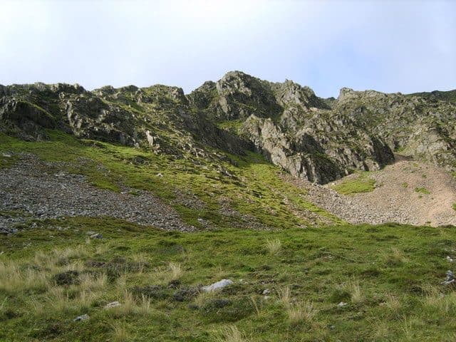
Photo: Michael Graham via Geograph, CC BY-SA 2.0
About Eel Crag (Crag Hill)
The hub of the Coledale skyline, sitting between Grasmoor and Sail. A trig-topped summit gives big looks into Gasgale Gill and across to the Scafells. Often woven into the Coledale or Buttermere horseshoes for a grand day out.
Ordnance Survey maps now call this fell Crag Hill and keep the name Eel Crag for the cliffs on its northern face. It sits at the hub of the highest ground in the North Western Fells, with ridges running out north, south, east and west. Grasmoor is higher, but the others all meet here.
Braithwaite is the start for the Coledale round. Park in the village or at the small car park near the foot of the Whinlatter road, and follow the Coledale mine road towards Force Crag Mine and up to Coledale Hause, the broad grassy col at the head of the valley. From the hause a path turns the crags to the west, climbs beside a stream to the col with Grasmoor, then goes up a wide path to the top. Eel Crag itself, straight above the hause, is steep boulder scree and rock and no place for walkers. From the east, the ridge from Sail crosses The Scar, a narrow rocky crest with a few easy rock steps. From Crummock Water you can follow Rannerdale Beck or Gasgale Gill, and from Buttermere the ridge comes up over Whiteless Pike and Wandope.
The top is a stony plateau with a rather battered Ordnance Survey trig pillar. Just beyond it the ground falls gently at first and then over cliffs into Coledale, with Force Crag Mine below and Keswick, Skiddaw and Blencathra at the end of the valley. Every major fell group is in view, the Scafells especially.
Unlike most of the fells around Coledale, Crag Hill was never mined. Many people fold it into a round of Coledale or Gasgale Gill, crossing to or from Hopegill Head by Coledale Hause.
In winter
The summit plateau is broad and featureless, and just past the trig point the ground falls over cliffs into Coledale, so navigation matters in mist or snow. The rock steps on The Scar ice up, and the direct line up Eel Crag from Coledale Hause is steep boulder scree to avoid in any season.
- Waterfall Route
- Great Views
- Dog Friendly
Sources: Wikipedia: Crag Hill, Walk Lakes: A Shorter Coledale Round, Walk Lakes: Grasmoor via Lad Howes ridge. Updated .
Summit
- OS grid ref
- NY 192 203
- Latitude
- 54.57203° N
- Longitude
- 3.25028° W
Walking up Eel Crag (Crag Hill)
The nearest car park on foot is Revelin Moss, 4.9 km (3.1 miles) from the summit along mapped paths. Directions to the car park
Route from Revelin Moss
- Distance
- 4.9 km
- 3.1 miles, one way
- Ascent
- 723 m
- Total climb to the summit
- Time up
- 2 h 6 min
- Allow 1 to 3 hours
Times use Naismith’s rule, 5 km/h on the flat plus extra time for the climb, with Langmuir’s corrections. It’s a rule of thumb for the way up only, so add stops, weather and the walk back down.
The route follows paths mapped by OpenStreetMap contributors and isn’t a guided line. This car park was picked automatically and hasn’t been checked by hand yet, so compare it with a map. Check the mountain forecast before you go and carry a map and compass.
Eel Crag (Crag Hill) questions
Is Eel Crag (Crag Hill) a Wainwright?
How high is Eel Crag (Crag Hill)?
Where do you park for Eel Crag (Crag Hill)?
How long does it take to climb Eel Crag (Crag Hill)?
How hard is Eel Crag (Crag Hill)?
Which Wainwrights are near Eel Crag (Crag Hill)?
What is the grid reference for the summit of Eel Crag (Crag Hill)?
Often walked with Eel Crag (Crag Hill)
Fells people usually take in on the same day.
Eel Crag (Crag Hill) in our guides
Wainwrights near Eel Crag (Crag Hill)
Straight-line distance and direction from the summit.
 Sail773 m0.6 km E
 Wandope774 m0.8 km SW
 Scar Crags672 m1.5 km E
 Ard Crags581 m1.5 km E
 Knott Rigg556 m1.6 km S
 Grasmoor852 m1.8 km W
More in the North Western Fells
- Grasmoor852 m
- Grisedale Pike791 m
- Wandope774 m
- Sail773 m
- Hopegill Head770 m
- Dale Head753 m
- Robinson737 m
- Hindscarth727 m
- Whiteside (west top)707 m
- Scar Crags672 m
- Whiteless Pike660 m
- High Spy653 m
- Causey Pike637 m
- Ard Crags581 m
- Maiden Moor575 m
- Outerside568 m
- Knott Rigg556 m
- Lord's Seat552 m
- Whinlatter (Brown How)517 m
- Broom Fell511 m
- Barf469 m
- Barrow455 m
- Graystones452 m
- Catbells451 m
- Ling Fell373 m
- Sale Fell359 m
- Rannerdale Knotts355 m
- Castle Crag290 m
Bag Eel Crag (Crag Hill) with Upfell
Reach the summit and capture Eel Crag (Crag Hill), even with no signal. It goes on your round of the 214 with its own patch.
Coming soon to theApp Store