Far Eastern Fells · Book 2
High Street
High Street is a Wainwright, one of the 214 Lake District fells in Alfred Wainwright’s Pictorial Guides. At 828 m (2,717 ft) it is the 25th highest of the 214 and the highest in the Far Eastern Fells.
- Height
- 828 m
- 2,717 ft
- Rank
- 25
- of 214
- In area
- 1
- of 36
- Difficulty
- Moderate
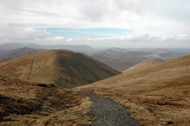
Photo: Karen Hope via Geograph, CC BY-SA 2.0
About High Street
A broad, high plateau with the line of a Roman road and stories of old summit fairs. Edges break into fine crags above Blea Water and Haweswater, while long ridges make for big-stride walking. A day for distance and sky.
The best way up starts from Mardale Head, at the end of the long, narrow road along Haweswater. The car park is free and holds about 30 cars (postcode CA10 2RP), and no bus goes there. Walk round the head of the reservoir, cross Mardale Beck by the footbridge, and climb onto the ridge of Rough Crag. After the dip at Caspel Gate, which can be boggy, Long Stile climbs in a series of humps to the plateau, with Blea Water in its corrie on your left. The ridge looks sharp from below but is broad and never knife-edged. A drystone wall keeps you company, and there is only a little easy scrambling.
A good return goes south over Mardale Ill Bell, down to Nan Bield Pass and past Small Water back to the car. Hartsop by The Knott, Patterdale, Troutbeck and Kentmere all make longer days.
The summit is a wide grassy plateau with a trig pillar beside the wall. The view reaches the Pennines to the east and the Helvellyn range and the Southern Fells to the west.
Racecourse Hill
The Romans ran a road over the plateau between their forts at Brougham and Ambleside, keeping to the tops to avoid the wooded, marshy valleys. On a clear day you can still trace it, faintly in places. The summit is also called Racecourse Hill. Every 12 July, shepherds gathered here to hand back stray sheep, with wrestling and horse racing alongside, until the meetings ended in 1835.
Blea Water is the deepest tarn in the Lake District at about 61 metres. The village of Mardale lies drowned under the reservoir, and Riggindale below the summit was home to England's last golden eagle, which has not been seen since 2016.
In winter
The summit plateau is so flat and featureless that in mist or snow it is easy to lose your line, and its eastern edge breaks off in crags above Blea Water and Riggindale. Use the wall along the ridge as a handrail, and take a bearing for the top of Long Stile or Nan Bield before you set off.
- Great Views
- Popular
- Dog Friendly
Sources: Wikipedia: High Street, Mud and Routes: High Street from Mardale Head via Rough Crag and Long Stile. Updated .
Summit
- OS grid ref
- NY 440 110
- Latitude
- 54.49168° N
- Longitude
- 2.86484° W
Walking up High Street
The nearest car park on foot is Mardale Head Car Park, 3.6 km (2.2 miles) from the summit along mapped paths. Directions to the car park
Route from Mardale Head Car Park
- Distance
- 3.6 km
- 2.2 miles, one way
- Ascent
- 593 m
- Total climb to the summit
- Time up
- 1 h 38 min
- Allow 1 to 3 hours
Times use Naismith’s rule, 5 km/h on the flat plus extra time for the climb, with Langmuir’s corrections. It’s a rule of thumb for the way up only, so add stops, weather and the walk back down.
The route follows paths mapped by OpenStreetMap contributors and isn’t a guided line. Check the mountain forecast before you go and carry a map and compass.
High Street questions
Is High Street a Wainwright?
How high is High Street?
Where do you park for High Street?
How long does it take to climb High Street?
How hard is High Street?
Which Wainwrights are near High Street?
What is the grid reference for the summit of High Street?
Often walked with High Street
Fells people usually take in on the same day.
High Street in our guides
Wainwrights near High Street
Straight-line distance and direction from the summit.
 Mardale Ill Bell760 m1.2 km SE
 Thornthwaite Crag784 m1.4 km SW
 Gray Crag699 m1.6 km NW
 Kidsty Pike780 m1.7 km NE
 The Knott739 m1.7 km N
 Rampsgill Head792 m1.7 km N
More in the Far Eastern Fells
- High Raise [Martindale]802 m
- Rampsgill Head792 m
- Thornthwaite Crag784 m
- Kidsty Pike780 m
- Harter Fell [Mardale]779 m
- Caudale Moor (Stony Cove Pike)763 m
- Mardale Ill Bell760 m
- Ill Bell757 m
- The Knott739 m
- Kentmere Pike730 m
- Froswick720 m
- Branstree713 m
- Yoke706 m
- Gray Crag699 m
- Rest Dodd696 m
- Wether Hill673 m
- Loadpot Hill671 m
- Tarn Crag [Longsleddale]664 m
- Place Fell657 m
- Selside Pike655 m
- Grey Crag638 m
- Hartsop Dodd618 m
- Shipman Knotts587 m
- The Nab576 m
- Angletarn Pikes567 m
- Brock Crags561 m
- Arthur's Pike533 m
- Bonscale Pike524 m
- Sallows516 m
- Beda Fell (Beda Head)509 m
- Wansfell (Baystones)487 m
- Sour Howes483 m
- Steel Knotts (Pikeawassa)432 m
- Hallin Fell388 m
- Troutbeck Tongue364 m
Bag High Street with Upfell
Reach the summit and capture High Street, even with no signal. It goes on your round of the 214 with its own patch.
Coming soon to theApp Store