Far Eastern Fells · Book 2
Ill Bell
Ill Bell is a Wainwright, one of the 214 Lake District fells in Alfred Wainwright’s Pictorial Guides. At 757 m (2,484 ft) it is the 60th highest of the 214 and the 9th highest in the Far Eastern Fells.
- Height
- 757 m
- 2,484 ft
- Rank
- 60
- of 214
- In area
- 9
- of 36
- Difficulty
- Moderate
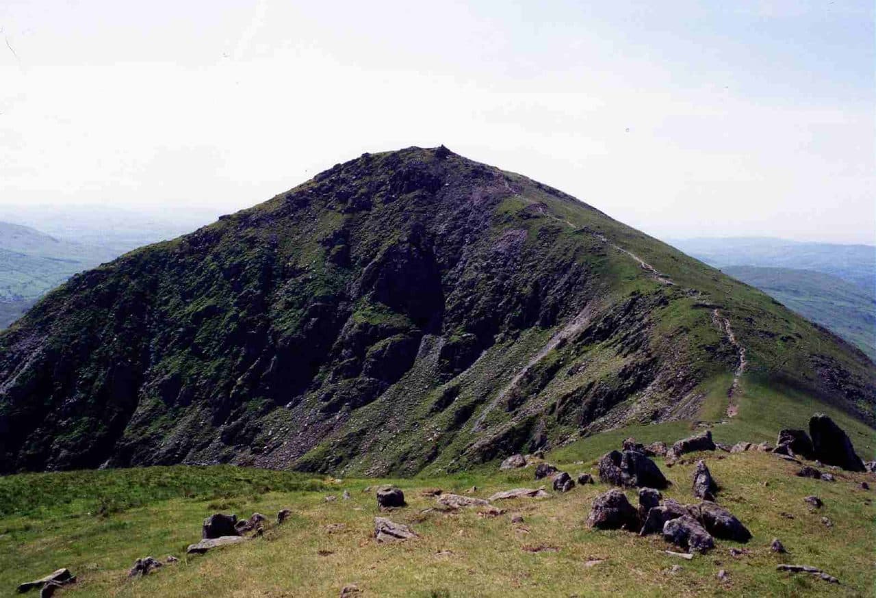
Photo: Mick Knapton via Wikimedia Commons
About Ill Bell
A sharp cone on the Kentmere Horseshoe with fine ridge walking to Froswick and Yoke. Summit cairns perch above steep drops that give a proper mountain feel.
With Yoke to the south and Froswick to the north, Ill Bell makes a switchback ridge between the Kentmere and Troutbeck valleys. The name probably comes from its bell shape. The summit is small and pointed, and much stonier than most Far Eastern tops. Several tall, well built cairns stand on and around it, which makes the fell easy to recognise from a distance.
The top is a good viewpoint. Windermere lies to the south, the Scafells are on the western skyline, and you can trace the whole of the Kentmere Horseshoe. Look over Nan Bield Pass and you can see Cross Fell and the Dun Fells in the Pennines.
On the Kentmere Horseshoe, Ill Bell comes early in the day. The start is the village hall in Kentmere, north of Staveley, with parking for fewer than half a dozen cars and an honesty box. Farmers sometimes open a field for parking, but you can't count on it, and the Kentmere Rambler bus has stopped running. Walk Lakes goes up the Garburn Pass, a very rough track, to Yoke. From there a good path runs north along the ridge to Ill Bell. The full horseshoe is about 20.7 km with 1,085 m of ascent. Allow a long day.
From Troutbeck you can climb to the ridge by the Garburn Road. Another line goes directly up from Hagg Gill through the northernmost quarry. From the Kentmere side, you can strike up from Kentmere Reservoir over Lead Howes.
The west flank drops steeply to Hagg Gill. On the east, Over Cove and Rainsborrow Cove have cut into the fell and left only narrow ridges linking it to its neighbours, with rough ground and scree running down towards the reservoir.
In winter
Walk Lakes flags rocky, awkward ground on Ill Bell's upper slopes and a steep descent through boulders towards Froswick, and ice turns both into slow work. The Kentmere side is rough and full of scree above the reservoir, so stay on the ridge path.
- Ridge Walk
- Great Views
- Potentially Dangerous
- Dog Friendly
Sources: Wikipedia: Ill Bell, Walk Lakes: The Kentmere Horseshoe. Updated .
Summit
- OS grid ref
- NY 436 077
- Latitude
- 54.46200° N
- Longitude
- 2.87082° W
Walking up Ill Bell
The nearest car park on foot is Hartsop, 6.6 km (4.1 miles) from the summit along mapped paths. Directions to the car park
Route from Hartsop
- Distance
- 6.6 km
- 4.1 miles, one way
- Ascent
- 755 m
- Total climb to the summit
- Time up
- 2 h 29 min
- Allow 1 to 4 hours
Times use Naismith’s rule, 5 km/h on the flat plus extra time for the climb, with Langmuir’s corrections. It’s a rule of thumb for the way up only, so add stops, weather and the walk back down.
The route follows paths mapped by OpenStreetMap contributors and isn’t a guided line. This car park was picked automatically and hasn’t been checked by hand yet, so compare it with a map. Check the mountain forecast before you go and carry a map and compass.
Ill Bell questions
Is Ill Bell a Wainwright?
How high is Ill Bell?
Where do you park for Ill Bell?
How long does it take to climb Ill Bell?
How hard is Ill Bell?
Which Wainwrights are near Ill Bell?
What is the grid reference for the summit of Ill Bell?
Often walked with Ill Bell
Fells people usually take in on the same day.
Ill Bell in our guides
Wainwrights near Ill Bell
Straight-line distance and direction from the summit.
 Froswick720 m0.8 km N
 Yoke706 m1.0 km S
 Troutbeck Tongue364 m2.0 km SW
 Thornthwaite Crag784 m2.3 km N
 Mardale Ill Bell760 m2.6 km NE
 Harter Fell [Mardale]779 m2.8 km NE
More in the Far Eastern Fells
- High Street828 m
- High Raise [Martindale]802 m
- Rampsgill Head792 m
- Thornthwaite Crag784 m
- Kidsty Pike780 m
- Harter Fell [Mardale]779 m
- Caudale Moor (Stony Cove Pike)763 m
- Mardale Ill Bell760 m
- The Knott739 m
- Kentmere Pike730 m
- Froswick720 m
- Branstree713 m
- Yoke706 m
- Gray Crag699 m
- Rest Dodd696 m
- Wether Hill673 m
- Loadpot Hill671 m
- Tarn Crag [Longsleddale]664 m
- Place Fell657 m
- Selside Pike655 m
- Grey Crag638 m
- Hartsop Dodd618 m
- Shipman Knotts587 m
- The Nab576 m
- Angletarn Pikes567 m
- Brock Crags561 m
- Arthur's Pike533 m
- Bonscale Pike524 m
- Sallows516 m
- Beda Fell (Beda Head)509 m
- Wansfell (Baystones)487 m
- Sour Howes483 m
- Steel Knotts (Pikeawassa)432 m
- Hallin Fell388 m
- Troutbeck Tongue364 m
Bag Ill Bell with Upfell
Reach the summit and capture Ill Bell, even with no signal. It goes on your round of the 214 with its own patch.
Coming soon to theApp Store