Eastern Fells · Book 1
Hart Side
Hart Side is a Wainwright, one of the 214 Lake District fells in Alfred Wainwright’s Pictorial Guides. At 756 m (2,480 ft) it is the 61st highest of the 214 and the 16th highest in the Eastern Fells.
- Height
- 756 m
- 2,480 ft
- Rank
- 61
- of 214
- In area
- 16
- of 35
- Difficulty
- Easy
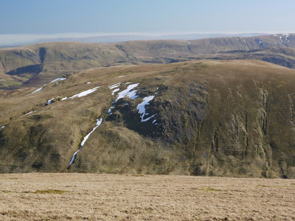
Photo: Silence-is-infinite via Wikimedia Commons
About Hart Side
An eastern outpost of the Helvellyn range with gentle approaches and wide views to the Pennines. A good leg-stretcher folded into Dods days.
Hart Side stands on a side ridge that runs east from Stybarrow Dodd towards Ullswater, and far fewer people climb it than the Dodds on the main ridge. Its approaches are gentle and mostly grassy.
The usual start is the free car park at High Row above Dockray (NY 380 219), which takes about 15 cars and fills early at weekends. Walk to Dowthwaitehead, then climb to Birkett Fell and follow the ridge on to Hart Side. The stretch from Dowthwaitehead to the wall is boggy after rain. A longer route of about 10 km starts at the small National Trust car park at Park Brow on the Aira Force road (NY 397 205). It crosses Glencoyne Park on narrow paths, some traversing steep slopes above the lake, before joining the ridge at Birkett Fell. From Glencoyne there is also a steep, pathless climb beside Deepdale Slack, or the south-east shoulder of Green Side above the old Greenside lead mine.
The top is grassy with scattered boulders and several small cairns. A few metres south is a long east to west trench, dug by prospectors following a lead vein, with a shallow hollow beside it. Higher ground to the west and the lie of the land to the east hide most of Ullswater, but Great Dodd and Stybarrow Dodd are close across Deepdale, and there are glimpses of Scafell Pike through the gaps. For the lake, go back to Birkett Fell.
Birkett Fell is named after Lord Birkett. In 1962 his speech in the House of Lords helped defeat Manchester Corporation's plan to turn Ullswater into a reservoir, and he died a few days later.
In winter
The path from Dowthwaitehead towards Birkett Fell is boggy and freezes into rough, uneven ground, and the ridge is open to wind from the east. In snow the rounded top and the old prospectors' trench near the summit are easy to lose.
- Great Views
- Family Walk
- Dog Friendly
Sources: Wikipedia: Hart Side, Walk Lakes: A short walk to Hart Side from Park Brow. Updated .
Summit
- OS grid ref
- NY 358 197
- Latitude
- 54.56887° N
- Longitude
- 2.99315° W
- Area
- Eastern Fells
Walking up Hart Side
The nearest car park on foot is Bury Jubilee Hut, 3.7 km (2.3 miles) from the summit along mapped paths. Directions to the car park
Route from Bury Jubilee Hut
- Distance
- 3.7 km
- 2.3 miles, one way
- Ascent
- 462 m
- Total climb to the summit
- Time up
- 1 h 27 min
- Allow 1 to 2 hours
Times use Naismith’s rule, 5 km/h on the flat plus extra time for the climb, with Langmuir’s corrections. It’s a rule of thumb for the way up only, so add stops, weather and the walk back down.
The route follows paths mapped by OpenStreetMap contributors and isn’t a guided line. This car park was picked automatically and hasn’t been checked by hand yet, so compare it with a map. Check the mountain forecast before you go and carry a map and compass.
Hart Side questions
Is Hart Side a Wainwright?
How high is Hart Side?
Where do you park for Hart Side?
How long does it take to climb Hart Side?
How hard is Hart Side?
Which Wainwrights are near Hart Side?
What is the grid reference for the summit of Hart Side?
Often walked with Hart Side
Fells people usually take in on the same day.
Wainwrights near Hart Side
Straight-line distance and direction from the summit.
 Stybarrow Dodd844 m1.8 km SW
 Sheffield Pike676 m1.9 km SE
 Great Dodd857 m1.9 km NW
 Watson's Dodd789 m2.3 km W
 Raise883 m2.8 km SW
 Glenridding Dodd442 m3.1 km SE
More in the Eastern Fells
- Helvellyn950 m
- Nethermost Pike891 m
- Catstycam890 m
- Raise883 m
- Fairfield873 m
- White Side863 m
- Dollywaggon Pike859 m
- Great Dodd857 m
- Stybarrow Dodd844 m
- Saint Sunday Crag841 m
- Hart Crag822 m
- Dove Crag792 m
- Watson's Dodd789 m
- Red Screes776 m
- Great Rigg766 m
- Seat Sandal737 m
- Clough Head726 m
- Birkhouse Moor718 m
- Sheffield Pike676 m
- High Pike [Scandale]656 m
- Middle Dodd654 m
- Little Hart Crag637 m
- Birks622 m
- Heron Pike612 m
- Hartsop above How581 m
- Great Mell Fell537 m
- High Hartsop Dodd519 m
- Low Pike508 m
- Little Mell Fell505 m
- Stone Arthur504 m
- Gowbarrow Fell481 m
- Nab Scar450 m
- Glenridding Dodd442 m
- Arnison Crag433 m
Bag Hart Side with Upfell
Reach the summit and capture Hart Side, even with no signal. It goes on your round of the 214 with its own patch.
Coming soon to theApp Store