Eastern Fells · Book 1
Great Mell Fell
Great Mell Fell is a Wainwright, one of the 214 Lake District fells in Alfred Wainwright’s Pictorial Guides. At 537 m (1,762 ft) it is the joint 154th highest of the 214 and the 27th highest in the Eastern Fells.
- Height
- 537 m
- 1,762 ft
- Rank
- =154
- of 214
- In area
- 27
- of 35
- Difficulty
- Easy
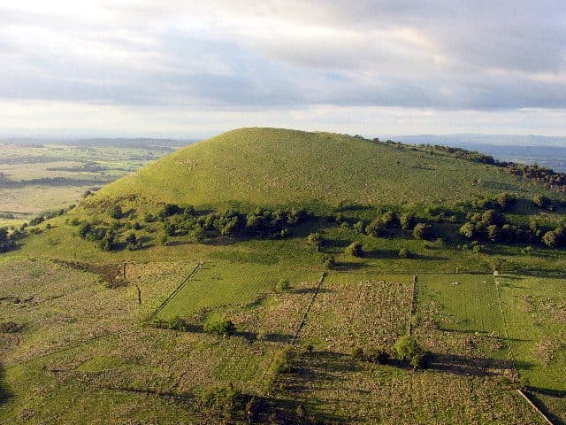
Photo: Simon Ledingham via Geograph, CC BY-SA 2.0
About Great Mell Fell
A rounded, isolated hill north of Ullswater, standing alone above farmland. It has no crags, only steady grassy slopes through wind-bent trees to a summit with wide views of Blencathra and the Helvellyn range.
Great Mell Fell rises alone out of marshy farmland north of Ullswater, a smooth rounded hill with no crags at all. The rock explains the shape. It is made of Mell Fell Conglomerate, a reddish pebbly sedimentary rock around 375 million years old, found almost nowhere else among the fells, and boulders of it lie on the slopes and in the becks.
The usual parking is a small muddy pull-in at the end of a rough lane by Brownrigg Farm (NY 407 246), on the minor road between Matterdale End and the A66. It holds only three or four cars. A track leads through two gates into woodland, then a path forks right and climbs round the fell through bracken and grass to the top. Out and back it is about 3.5 km with 270 m of ascent. The eastern ridge from the south-east corner is the gentler way up, and the western end is steep but grassy. There is also access from just south of Troutbeck on the A5091, along the old rifle range.
The whole fell is National Trust land and open access. The range ran from the 1890s into the 1950s, and walkers were kept off while it was in use. Spent .303 rounds still turn up in the soil of the butts.
Oak, rowan and birch cover the lower slopes, and higher up there are larches and pines bent by the wind. The summit is a low mound marked on the OS map as a tumulus, probably a Bronze Age burial, with a cairn beside it. Blencathra and the Dodds fill the view west, and to the south you look over Ullswater to the Eastern and Far Eastern Fells as far as Red Screes. East, the Eden Valley leads the eye to the north Pennines.
In winter
There is no crag or exposure, but the lane and lower track from Brownrigg get deeply muddy and the paths through the bracken stay wet. Being low and quick, it is a good short winter day, with Blencathra and the Dodds under snow across the valley.
- Dog Friendly
Sources: Wikipedia: Great Mell Fell, Walk Lakes: Great Mell Fell. Updated .
Summit
- OS grid ref
- NY 396 253
- Latitude
- 54.61983° N
- Longitude
- 2.93564° W
- Area
- Eastern Fells
Walking up Great Mell Fell
The nearest car park on foot is High Cascades car park, 6.0 km (3.7 miles) from the summit along mapped paths. Directions to the car park
Route from High Cascades car park
- Distance
- 6.0 km
- 3.7 miles, one way
- Ascent
- 320 m
- Total climb to the summit
- Time up
- 1 h 40 min
- Allow 1 to 3 hours
Times use Naismith’s rule, 5 km/h on the flat plus extra time for the climb, with Langmuir’s corrections. It’s a rule of thumb for the way up only, so add stops, weather and the walk back down.
The route follows paths mapped by OpenStreetMap contributors and isn’t a guided line. Check the mountain forecast before you go and carry a map and compass.
Great Mell Fell questions
Is Great Mell Fell a Wainwright?
How high is Great Mell Fell?
Where do you park for Great Mell Fell?
How long does it take to climb Great Mell Fell?
How hard is Great Mell Fell?
Which Wainwrights are near Great Mell Fell?
What is the grid reference for the summit of Great Mell Fell?
Often walked with Great Mell Fell
Fells people usually take in on the same day.
Great Mell Fell in our guides
Wainwrights near Great Mell Fell
Straight-line distance and direction from the summit.
 Little Mell Fell505 m3.0 km SE
 Gowbarrow Fell481 m3.7 km S
 Souther Fell522 m5.6 km NW
 Hallin Fell388 m6.6 km SE
 Hart Side756 m6.8 km SW
 Clough Head726 m6.9 km SW
More in the Eastern Fells
- Helvellyn950 m
- Nethermost Pike891 m
- Catstycam890 m
- Raise883 m
- Fairfield873 m
- White Side863 m
- Dollywaggon Pike859 m
- Great Dodd857 m
- Stybarrow Dodd844 m
- Saint Sunday Crag841 m
- Hart Crag822 m
- Dove Crag792 m
- Watson's Dodd789 m
- Red Screes776 m
- Great Rigg766 m
- Hart Side756 m
- Seat Sandal737 m
- Clough Head726 m
- Birkhouse Moor718 m
- Sheffield Pike676 m
- High Pike [Scandale]656 m
- Middle Dodd654 m
- Little Hart Crag637 m
- Birks622 m
- Heron Pike612 m
- Hartsop above How581 m
- High Hartsop Dodd519 m
- Low Pike508 m
- Little Mell Fell505 m
- Stone Arthur504 m
- Gowbarrow Fell481 m
- Nab Scar450 m
- Glenridding Dodd442 m
- Arnison Crag433 m
Bag Great Mell Fell with Upfell
Reach the summit and capture Great Mell Fell, even with no signal. It goes on your round of the 214 with its own patch.
Coming soon to theApp Store