Eastern Fells · Book 1
Great Dodd
Great Dodd is a Wainwright, one of the 214 Lake District fells in Alfred Wainwright’s Pictorial Guides. At 857 m (2,812 ft) it is the 19th highest of the 214 and the 8th highest in the Eastern Fells.
- Height
- 857 m
- 2,812 ft
- Rank
- 19
- of 214
- In area
- 8
- of 35
- Difficulty
- Moderate
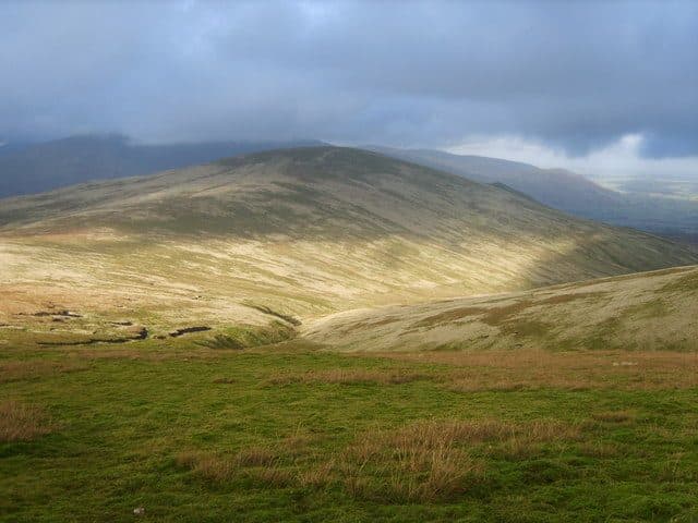
Photo: Michael Graham via Geograph, CC BY-SA 2.0
About Great Dodd
A broad-backed giant of the Dodds with long grassy ridges and big horizons. Paths from Dockray or Sticks Pass give steady climbs, and the summit wind shelter makes a good stop on blustery days. Less dramatic than its neighbours but wonderfully expansive. A superb vantage over the Eastern Fells.
North of Sticks Pass the Helvellyn range turns into a line of grassy domes, and Great Dodd, at 857 m, is the highest of them. It sits between Thirlmere and Ullswater, on the watershed between the Derwent and the Eden.
From the east, the car park at High Row above Dockray is the start. The direct line follows the north-east ridge over Low How, High Brow and Randerside, across National Trust land on Matterdale Common. Other paths follow the Old Coach Road towards Mosedale or climb beside Groove Beck. From Legburthwaite in the west, paths go up the ravine of Mill Gill to Little Dodd, or beside Ladknott Gill, and shepherds' trods lead to Calfhow Pike. Mill Gill, Beckthorns Gill and Sandbed Gill are climbers' scrambles with no walking line. Parking at the Thirlmere recreation hall on Stanah Lane (NY 318 189) or nearby at Legburthwaite suits a long round of the Dodds from Sticks Pass to Clough Head, which is about 20 km with over 1000 m of climbing.
The paths are broad and clear, and the ground is mostly grass, wet in places. Some ridge walkers take a contouring path on the west side and miss the summit altogether.
The top is a short, rounded, grassy ridge scattered with stones. A newer cairn at the north-west end marks the highest point, and the older, bigger cairn about 100 m south has a wind shelter built into it. On a clear day you can see much of the Lake District, the hills of south-west Scotland, the Eden Valley and the Pennines. The dome shape hides the valleys below, so walk a little way off for a better foreground. The beck in Deep Dale, below the east side, runs on to become Aira Force.
In winter
The summit is a broad rounded dome, and in snow and cloud there are few features to steer by, so carry a compass bearing for the ridge you intend to leave on. The approach from Dockray over Randerside is long and open to the wind for its whole length.
- Great Views
- Family Walk
- Dog Friendly
Sources: Wikipedia: Great Dodd, Walk Lakes: The Dodds and Clough Head. Updated .
Summit
- OS grid ref
- NY 341 205
- Latitude
- 54.57592° N
- Longitude
- 3.01950° W
- Area
- Eastern Fells
Walking up Great Dodd
The nearest car park on foot is Legburthwaite Car Park, 4.2 km (2.6 miles) from the summit along mapped paths. Directions to the car park
Route from Legburthwaite Car Park
- Distance
- 4.2 km
- 2.6 miles, one way
- Ascent
- 704 m
- Total climb to the summit
- Time up
- 1 h 56 min
- Allow 1 to 3 hours
Times use Naismith’s rule, 5 km/h on the flat plus extra time for the climb, with Langmuir’s corrections. It’s a rule of thumb for the way up only, so add stops, weather and the walk back down.
The route follows paths mapped by OpenStreetMap contributors and isn’t a guided line. Check the mountain forecast before you go and carry a map and compass.
Great Dodd questions
Is Great Dodd a Wainwright?
How high is Great Dodd?
Where do you park for Great Dodd?
How long does it take to climb Great Dodd?
How hard is Great Dodd?
Which Wainwrights are near Great Dodd?
What is the grid reference for the summit of Great Dodd?
Often walked with Great Dodd
Fells people usually take in on the same day.
Wainwrights near Great Dodd
Straight-line distance and direction from the summit.
 Watson's Dodd789 m1.2 km SW
 Stybarrow Dodd844 m1.6 km S
 Hart Side756 m1.9 km SE
 Clough Head726 m2.1 km NW
 Raise883 m3.1 km S
 Sheffield Pike676 m3.6 km SE
More in the Eastern Fells
- Helvellyn950 m
- Nethermost Pike891 m
- Catstycam890 m
- Raise883 m
- Fairfield873 m
- White Side863 m
- Dollywaggon Pike859 m
- Stybarrow Dodd844 m
- Saint Sunday Crag841 m
- Hart Crag822 m
- Dove Crag792 m
- Watson's Dodd789 m
- Red Screes776 m
- Great Rigg766 m
- Hart Side756 m
- Seat Sandal737 m
- Clough Head726 m
- Birkhouse Moor718 m
- Sheffield Pike676 m
- High Pike [Scandale]656 m
- Middle Dodd654 m
- Little Hart Crag637 m
- Birks622 m
- Heron Pike612 m
- Hartsop above How581 m
- Great Mell Fell537 m
- High Hartsop Dodd519 m
- Low Pike508 m
- Little Mell Fell505 m
- Stone Arthur504 m
- Gowbarrow Fell481 m
- Nab Scar450 m
- Glenridding Dodd442 m
- Arnison Crag433 m
Bag Great Dodd with Upfell
Reach the summit and capture Great Dodd, even with no signal. It goes on your round of the 214 with its own patch.
Coming soon to theApp Store