Eastern Fells · Book 1
Little Mell Fell
Little Mell Fell is a Wainwright, one of the 214 Lake District fells in Alfred Wainwright’s Pictorial Guides. At 505 m (1,657 ft) it is the 173rd highest of the 214 and the 30th highest in the Eastern Fells.
- Height
- 505 m
- 1,657 ft
- Rank
- 173
- of 214
- In area
- 30
- of 35
- Difficulty
- Easy
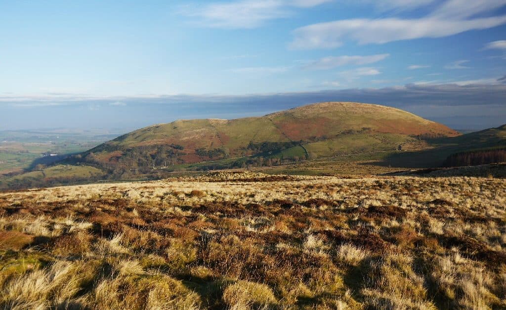
Photo: Silence-is-infinite via Wikimedia Commons
About Little Mell Fell
A solitary grassy dome at the edge of the Eastern Fells. Short, steep and direct from The Hause, it rewards quickly with open views of Ullswater and the Eden boundary hills. Ideal for a leg-stretcher in changeable weather or a family-friendly first Wainwright.
Sand and gravel, laid down in desert rivers and fans about 375 million years ago, make up this fell. The rock is Mell Fell Conglomerate, unlike the volcanic rock of the fells around it, and only the two Mell Fells are built of it. It erodes smoothly, which is why the fell is a neat, rounded grassy dome.
The short way up is from The Hause, a col on the minor road south of the fell, at NY 423 235. There is a lay-by for four or five cars. Cross the road to the gate and step stile, cross a boggy patch to a second gate, and climb straight up the steep fellside. After about 120 metres the slope eases, and a right fork takes you to the trig point. There and back is only 1.3 km, with 120 metres of climbing.
The ground is grass and bracken with a little gorse lower down. There is no rock to deal with. Longer approaches come from Lowthwaite Farm to the west and from the lane by the Cove camping park to the east, but only the southern part of the fell is open access land.
The summit is open all round, looking east over the Eden Valley to the Pennines, north to the Southern Uplands, and down into Martindale. Most of Ullswater stays hidden, though you can see its lower reaches.
A disused quarry on the eastern flank is a Site of Special Scientific Interest, with lichens, mosses and insects recorded there, and the rock it worked may have contained a mineral called chlorophaeite.
In winter
Short enough for the shortest day, but the first 120 metres above The Hause are steep grass that gets slippery in frost, and the patch by the roadside gate is boggy all winter. Cattle graze the lower slopes, so keep dogs close.
- Great Views
- Dog Friendly
- Family Walk
Sources: Wikipedia: Little Mell Fell, Walk Lakes: Little Mell Fell. Updated .
Summit
- OS grid ref
- NY 423 240
- Latitude
- 54.60801° N
- Longitude
- 2.89445° W
- Area
- Eastern Fells
Walking up Little Mell Fell
The nearest car park on foot is High Cascades car park, 5.1 km (3.2 miles) from the summit along mapped paths. Directions to the car park
Route from High Cascades car park
- Distance
- 5.1 km
- 3.2 miles, one way
- Ascent
- 399 m
- Total climb to the summit
- Time up
- 1 h 35 min
- Allow 1 to 2 hours
Times use Naismith’s rule, 5 km/h on the flat plus extra time for the climb, with Langmuir’s corrections. It’s a rule of thumb for the way up only, so add stops, weather and the walk back down.
The route follows paths mapped by OpenStreetMap contributors and isn’t a guided line. Check the mountain forecast before you go and carry a map and compass.
Little Mell Fell questions
Is Little Mell Fell a Wainwright?
How high is Little Mell Fell?
Where do you park for Little Mell Fell?
How long does it take to climb Little Mell Fell?
How hard is Little Mell Fell?
Which Wainwrights are near Little Mell Fell?
What is the grid reference for the summit of Little Mell Fell?
Often walked with Little Mell Fell
Fells people usually take in on the same day.
Little Mell Fell in our guides
Wainwrights near Little Mell Fell
Straight-line distance and direction from the summit.
 Gowbarrow Fell481 m2.7 km SW
 Great Mell Fell537 m3.0 km NW
 Hallin Fell388 m4.3 km S
 Bonscale Pike524 m5.0 km SE
 Arthur's Pike533 m5.0 km SE
 Steel Knotts (Pikeawassa)432 m6.1 km S
More in the Eastern Fells
- Helvellyn950 m
- Nethermost Pike891 m
- Catstycam890 m
- Raise883 m
- Fairfield873 m
- White Side863 m
- Dollywaggon Pike859 m
- Great Dodd857 m
- Stybarrow Dodd844 m
- Saint Sunday Crag841 m
- Hart Crag822 m
- Dove Crag792 m
- Watson's Dodd789 m
- Red Screes776 m
- Great Rigg766 m
- Hart Side756 m
- Seat Sandal737 m
- Clough Head726 m
- Birkhouse Moor718 m
- Sheffield Pike676 m
- High Pike [Scandale]656 m
- Middle Dodd654 m
- Little Hart Crag637 m
- Birks622 m
- Heron Pike612 m
- Hartsop above How581 m
- Great Mell Fell537 m
- High Hartsop Dodd519 m
- Low Pike508 m
- Stone Arthur504 m
- Gowbarrow Fell481 m
- Nab Scar450 m
- Glenridding Dodd442 m
- Arnison Crag433 m
Bag Little Mell Fell with Upfell
Reach the summit and capture Little Mell Fell, even with no signal. It goes on your round of the 214 with its own patch.
Coming soon to theApp Store