Eastern Fells · Book 1
Gowbarrow Fell
Gowbarrow Fell is a Wainwright, one of the 214 Lake District fells in Alfred Wainwright’s Pictorial Guides. At 481 m (1,578 ft) it is the 181st highest of the 214 and the 32nd highest in the Eastern Fells.
- Height
- 481 m
- 1,578 ft
- Rank
- 181
- of 214
- In area
- 32
- of 35
- Difficulty
- Easy
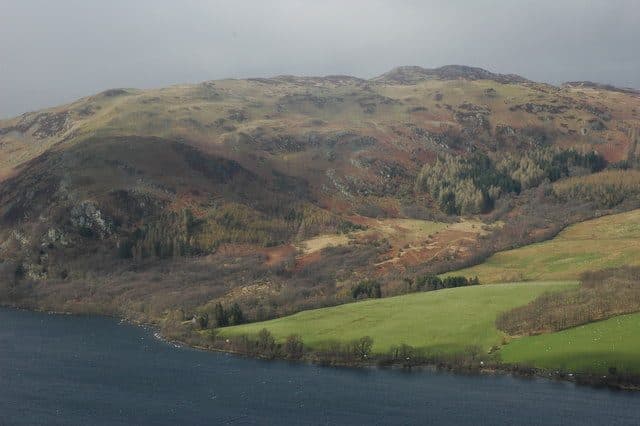
Photo: Philip Halling via Geograph, CC BY-SA 2.0
About Gowbarrow Fell
A compact Eastern Fell overlooking Ullswater. The terrace paths via Aira Force give drama and easy access, while the summit has a wide outlook from Helvellyn to the edge of the Pennines. Popular without feeling overdone.
Aira Force is where most walks up Gowbarrow begin. The National Trust pay and display car park sits where the A5091 meets the A592, below the falls, and the 508 bus between Penrith and Glenridding stops here too. From the car park you climb through the woods beside Aira Beck, with stone bridges and viewpoints over the main fall. The quickest way onto the fell is from Dockray at the top of the beck, about a mile from the summit.
The popular circuit goes up past the falls, follows the beck for a while and then climbs beside a wall onto the open fell. You come back round the south side on the terrace path, which is narrow in places, with steep ground falling to the lake and several flights of steps. On the open top the path is clear, but expect mud, peat among the heather and, in late summer, bracken. There is no scrambling.
Airy Crag
The summit is Airy Crag, a rocky knoll with an Ordnance Survey pillar carrying a National Trust plaque. It sits well back from the shore, so the lake is partly hidden, but you get Blencathra, the Mell Fells and the Helvellyn range. For the view up Ullswater towards Glenridding and Patterdale, go down to Green Hill on the lake side.
The whole fell was once a medieval deer park stocked with several hundred fallow deer. Lyulph's Tower, the castellated house near the falls, was built by a Duke of Norfolk as a hunting lodge, and you pass the ruins of a later shooting lodge on the fell. On 15 April 1802 William and Dorothy Wordsworth walked along the shore below and saw the daffodils in Glencoyne Bay that gave him his best known poem.
In winter
The narrow terrace path above Ullswater has steep drops on the lake side, and the stepped sections near the falls are shaded and slow to thaw, so take them carefully after a frost. The top is low enough to be a sensible short day when the Helvellyn range is under snow.
- Waterfall Route
- Great Views
- Popular
- Family Walk
- Kid Friendly
- Dog Friendly
Sources: Wikipedia: Gowbarrow Fell, Walk Lakes: Aira Force and Gowbarrow Fell, National Trust: Aira Force and Gowbarrow trail. Updated .
Summit
- OS grid ref
- NY 407 218
- Latitude
- 54.58809° N
- Longitude
- 2.91818° W
- Area
- Eastern Fells
Walking up Gowbarrow Fell
The nearest car park on foot is High Cascades car park, 1.9 km (1.2 miles) from the summit along mapped paths. Directions to the car park
Route from High Cascades car park
- Distance
- 1.9 km
- 1.2 miles, one way
- Ascent
- 230 m
- Total climb to the summit
- Time up
- 42 min
- Allow 1 to 2 hours
Times use Naismith’s rule, 5 km/h on the flat plus extra time for the climb, with Langmuir’s corrections. It’s a rule of thumb for the way up only, so add stops, weather and the walk back down.
The route follows paths mapped by OpenStreetMap contributors and isn’t a guided line. Check the mountain forecast before you go and carry a map and compass.
Gowbarrow Fell questions
Is Gowbarrow Fell a Wainwright?
How high is Gowbarrow Fell?
Where do you park for Gowbarrow Fell?
How long does it take to climb Gowbarrow Fell?
How hard is Gowbarrow Fell?
Which Wainwrights are near Gowbarrow Fell?
What is the grid reference for the summit of Gowbarrow Fell?
Often walked with Gowbarrow Fell
Fells people usually take in on the same day.
Gowbarrow Fell in our guides
- Doing the Wainwrights together: couples, clubs and dogs
- Wainwrights by bus: the Lake District without a car
- Wainwrights for kids: easy fells for children
- Wainwrights from Glenridding and Patterdale
- Wainwrights from Pooley Bridge
- Wainwrights to avoid in bad weather, and where to go instead
- Where people finish the Wainwrights: what the two completion registers show
- Winter Wainwrights: fells you can still reach when the passes shut
Wainwrights near Gowbarrow Fell
Straight-line distance and direction from the summit.
 Little Mell Fell505 m2.7 km NE
 Hallin Fell388 m3.2 km SE
 Great Mell Fell537 m3.7 km N
 Place Fell657 m4.9 km S
 Bonscale Pike524 m4.9 km E
 Steel Knotts (Pikeawassa)432 m4.9 km SE
More in the Eastern Fells
- Helvellyn950 m
- Nethermost Pike891 m
- Catstycam890 m
- Raise883 m
- Fairfield873 m
- White Side863 m
- Dollywaggon Pike859 m
- Great Dodd857 m
- Stybarrow Dodd844 m
- Saint Sunday Crag841 m
- Hart Crag822 m
- Dove Crag792 m
- Watson's Dodd789 m
- Red Screes776 m
- Great Rigg766 m
- Hart Side756 m
- Seat Sandal737 m
- Clough Head726 m
- Birkhouse Moor718 m
- Sheffield Pike676 m
- High Pike [Scandale]656 m
- Middle Dodd654 m
- Little Hart Crag637 m
- Birks622 m
- Heron Pike612 m
- Hartsop above How581 m
- Great Mell Fell537 m
- High Hartsop Dodd519 m
- Low Pike508 m
- Little Mell Fell505 m
- Stone Arthur504 m
- Nab Scar450 m
- Glenridding Dodd442 m
- Arnison Crag433 m
Bag Gowbarrow Fell with Upfell
Reach the summit and capture Gowbarrow Fell, even with no signal. It goes on your round of the 214 with its own patch.
Coming soon to theApp Store