Far Eastern Fells · Book 2
Hallin Fell
Hallin Fell is a Wainwright, one of the 214 Lake District fells in Alfred Wainwright’s Pictorial Guides. At 388 m (1,273 ft) it is the 203rd highest of the 214 and the 35th highest in the Far Eastern Fells.
- Height
- 388 m
- 1,273 ft
- Rank
- 203
- of 214
- In area
- 35
- of 36
- Difficulty
- Easy
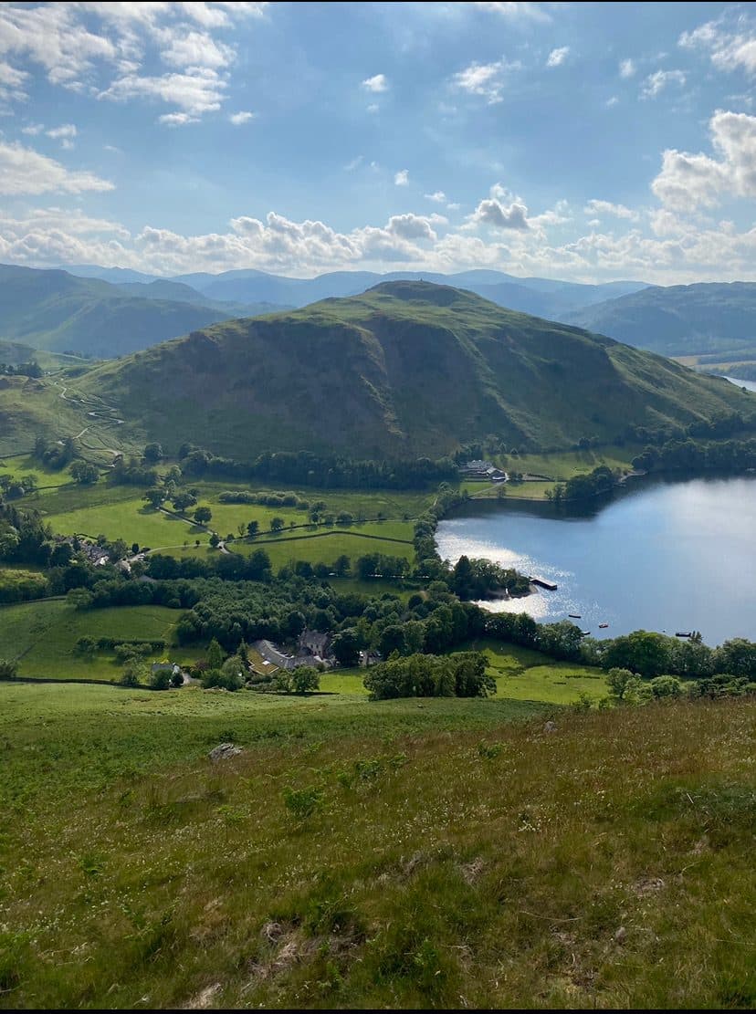
Photo: JoelHockley via Wikimedia Commons
About Hallin Fell
A classic Ullswater family hill with a grand cairn and huge lake views. It is a short pull from Howtown and a good first Wainwright. Stay for sunset if you can: the sun goes down behind the Helvellyn range.
If you park at the top of Martindale Hause, the summit is less than a kilometre away and about 160 m above you. There's a small free parking area opposite St Peter's Church and a few more spaces a little way down towards Howtown. The only road in is a narrow lane from Pooley Bridge, which gets busy on summer weekends. Most people follow the wide grass path straight up from the church. A full circuit is about 2 km and takes under an hour.
For a longer day, take the Ullswater steamer to Howtown pier and climb from the hamlet, or walk the lakeshore path. The shore path between Howtown and Patterdale runs through woods around the northern side of Hallin Fell, with a little easy scrambling over rock outcrops, and plenty of people walk it for its own sake.
The south and west slopes are smooth grass, steep enough to be slippery after rain. The north side, above the lake, is rougher and craggier. Geordie's Crag, its northernmost point, pushes out into Ullswater and marks the line between the lake's middle and lower reaches.
The top is a cluster of grassy knolls and rock, and a tall, square stone column stands on the highest point. It's big for such a small hill. The lake is spread out below, with Martindale, High Street, the Helvellyn range and Blencathra all round. For the view into Boredale and Martindale, walk on to the far knoll.
St Peter's Church
The church at the Hause was built in 1880 to 1882 and is known locally as the New Church. Most of its stained glass was made in 1975 by Jane Gray, and one window remembers the crew of the aircraft carrier HMS Glorious.
In winter
The steep grass on the south side of the fell gets slippery, but getting there is the bigger problem. The narrow road over Martindale Hause from Howtown is steep and zigzagging, and it ices up.
- Great Views
- Dog Friendly
Sources: Wikipedia: Hallin Fell, Walk Lakes: Hallin Fell, Wikipedia: St Peter's Church, Martindale. Updated .
Summit
- OS grid ref
- NY 433 198
- Latitude
- 54.57040° N
- Longitude
- 2.87848° W
Walking up Hallin Fell
The nearest car park on foot is White Lion Car Park, 7.2 km (4.4 miles) from the summit along mapped paths. Directions to the car park
Route from White Lion Car Park
- Distance
- 7.2 km
- 4.4 miles, one way
- Ascent
- 474 m
- Total climb to the summit
- Time up
- 2 h 10 min
- Allow 1 to 3 hours
Times use Naismith’s rule, 5 km/h on the flat plus extra time for the climb, with Langmuir’s corrections. It’s a rule of thumb for the way up only, so add stops, weather and the walk back down.
The route follows paths mapped by OpenStreetMap contributors and isn’t a guided line. This car park was picked automatically and hasn’t been checked by hand yet, so compare it with a map. Check the mountain forecast before you go and carry a map and compass.
Hallin Fell questions
Is Hallin Fell a Wainwright?
How high is Hallin Fell?
Where do you park for Hallin Fell?
How long does it take to climb Hallin Fell?
How hard is Hallin Fell?
Which Wainwrights are near Hallin Fell?
What is the grid reference for the summit of Hallin Fell?
Often walked with Hallin Fell
Fells people usually take in on the same day.

Hallin Fell in our guides
Wainwrights near Hallin Fell
Straight-line distance and direction from the summit.
 Steel Knotts (Pikeawassa)432 m1.8 km SE
 Bonscale Pike524 m2.1 km E
 Beda Fell (Beda Head)509 m2.7 km S
 Arthur's Pike533 m2.9 km E
 Loadpot Hill671 m3.0 km SE
 Gowbarrow Fell481 m3.2 km NW
More in the Far Eastern Fells
- High Street828 m
- High Raise [Martindale]802 m
- Rampsgill Head792 m
- Thornthwaite Crag784 m
- Kidsty Pike780 m
- Harter Fell [Mardale]779 m
- Caudale Moor (Stony Cove Pike)763 m
- Mardale Ill Bell760 m
- Ill Bell757 m
- The Knott739 m
- Kentmere Pike730 m
- Froswick720 m
- Branstree713 m
- Yoke706 m
- Gray Crag699 m
- Rest Dodd696 m
- Wether Hill673 m
- Loadpot Hill671 m
- Tarn Crag [Longsleddale]664 m
- Place Fell657 m
- Selside Pike655 m
- Grey Crag638 m
- Hartsop Dodd618 m
- Shipman Knotts587 m
- The Nab576 m
- Angletarn Pikes567 m
- Brock Crags561 m
- Arthur's Pike533 m
- Bonscale Pike524 m
- Sallows516 m
- Beda Fell (Beda Head)509 m
- Wansfell (Baystones)487 m
- Sour Howes483 m
- Steel Knotts (Pikeawassa)432 m
- Troutbeck Tongue364 m
Bag Hallin Fell with Upfell
Reach the summit and capture Hallin Fell, even with no signal. It goes on your round of the 214 with its own patch.
Coming soon to theApp Store