Eastern Fells · Book 1
Saint Sunday Crag
Saint Sunday Crag is a Wainwright, one of the 214 Lake District fells in Alfred Wainwright’s Pictorial Guides. At 841 m (2,759 ft) it is the joint 22nd highest of the 214 and the 10th highest in the Eastern Fells.
- Height
- 841 m
- 2,759 ft
- Rank
- =22
- of 214
- In area
- 10
- of 35
- Difficulty
- Moderate
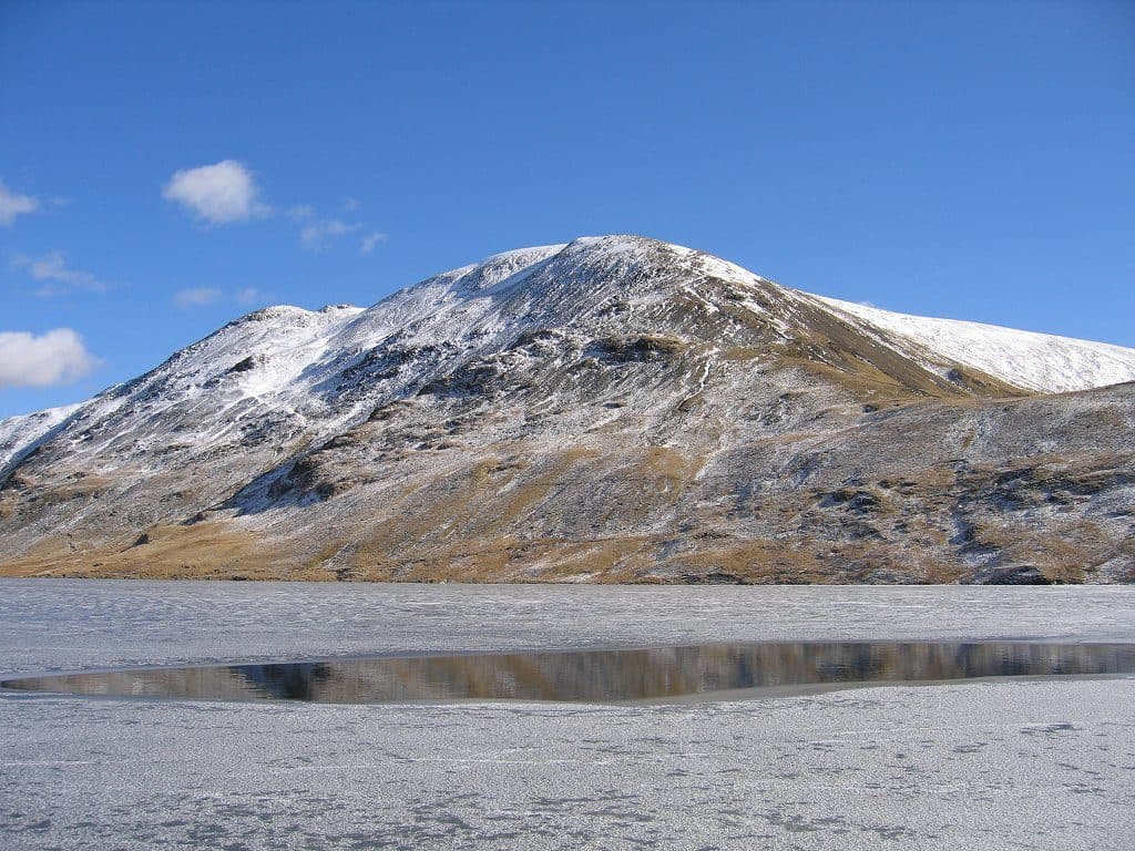
Photo: Paul Albertella
About Saint Sunday Crag
A fine whale-backed ridge above Grisedale with a handsome sweep of crags. Lines from Patterdale keep it varied, and from Fairfield you can come over Cofa Pike and across Deepdale Hause. The summit has commanding views to Helvellyn and Ullswater. A classic of the Fairfield group with real presence.
Most people climb Saint Sunday Crag from Patterdale, where its long ridge fills the view up the south side of Grisedale. Parking in the village is limited and fills fast at weekends, because the Helvellyn crowd want the same spaces. There is a pay car park at the Patterdale Hotel, and the 508 bus from Penrith stops in the village.
The standard route leaves the village and climbs through Glenamara Park with a wall on your right, then goes steeply up through bracken on old pitched paths to the shoulder by Birks. From there the north east ridge runs up to the summit, with views back over Ullswater and Place Fell. The top of Birks is a short detour, and Arnison Crag can be added at the start. A steeper option is the Elmhow zigzag path, which climbs the Grisedale face just north of the crags. From Bridgend in Deepdale you can go up over Lord's Seat and the east ridge by Gavel Pike.
On the south west side the ridge falls to Deepdale Hause, the narrowest point, where a thin path zigzags steeply down loose ground. Cofa Pike and Fairfield rise beyond it. A popular round climbs the ridge, drops to Grisedale Tarn and comes back down Grisedale, about 15km in all.
The summit is surprisingly flat and grassy, with two cairns, and another cairn at the northern end gives the view down Ullswater. Striding Edge and the crags of Fairfield are the big features across the valleys.
Saint Sunday is a local name for Saint Dominic, though nobody knows how his name came to be attached to the fell. The ridge is also on the high level alternative of Wainwright's Coast to Coast Walk, which brings a steady flow of walkers.
In winter
The descent from the summit to Deepdale Hause is steep, loose and zigzagging, and with snow or ice on it a slip could carry a long way. Think hardest about this section before you commit to a Fairfield round. The crags on the Grisedale face drop straight off the northern edge, so keep well back in mist.
- Ridge Walk
- Great Views
- Popular
- Dog Friendly
Sources: Wikipedia: St Sunday Crag, Walk Lakes: St Sunday Crag and Grisedale Tarn. Updated .
Summit
- OS grid ref
- NY 369 133
- Latitude
- 54.51193° N
- Longitude
- 2.97585° W
- Area
- Eastern Fells
Walking up Saint Sunday Crag
The nearest car park on foot is Seasonal Car park, 3.9 km (2.4 miles) from the summit along mapped paths. Directions to the car park
Route from Seasonal Car park
- Distance
- 3.9 km
- 2.4 miles, one way
- Ascent
- 690 m
- Total climb to the summit
- Time up
- 1 h 51 min
- Allow 1 to 3 hours
Times use Naismith’s rule, 5 km/h on the flat plus extra time for the climb, with Langmuir’s corrections. It’s a rule of thumb for the way up only, so add stops, weather and the walk back down.
The route follows paths mapped by OpenStreetMap contributors and isn’t a guided line. This car park was picked automatically and hasn’t been checked by hand yet, so compare it with a map. Check the mountain forecast before you go and carry a map and compass.
Saint Sunday Crag questions
Is Saint Sunday Crag a Wainwright?
How high is Saint Sunday Crag?
Where do you park for Saint Sunday Crag?
How long does it take to climb Saint Sunday Crag?
How hard is Saint Sunday Crag?
Which Wainwrights are near Saint Sunday Crag?
What is the grid reference for the summit of Saint Sunday Crag?
Often walked with Saint Sunday Crag
Fells people usually take in on the same day.
Saint Sunday Crag in our guides
Wainwrights near Saint Sunday Crag
Straight-line distance and direction from the summit.
 Birks622 m1.7 km NE
 Fairfield873 m1.9 km SW
 Hartsop above How581 m2.0 km SE
 Hart Crag822 m2.2 km S
 Dollywaggon Pike859 m2.3 km W
 Birkhouse Moor718 m2.6 km N
More in the Eastern Fells
- Helvellyn950 m
- Nethermost Pike891 m
- Catstycam890 m
- Raise883 m
- Fairfield873 m
- White Side863 m
- Dollywaggon Pike859 m
- Great Dodd857 m
- Stybarrow Dodd844 m
- Hart Crag822 m
- Dove Crag792 m
- Watson's Dodd789 m
- Red Screes776 m
- Great Rigg766 m
- Hart Side756 m
- Seat Sandal737 m
- Clough Head726 m
- Birkhouse Moor718 m
- Sheffield Pike676 m
- High Pike [Scandale]656 m
- Middle Dodd654 m
- Little Hart Crag637 m
- Birks622 m
- Heron Pike612 m
- Hartsop above How581 m
- Great Mell Fell537 m
- High Hartsop Dodd519 m
- Low Pike508 m
- Little Mell Fell505 m
- Stone Arthur504 m
- Gowbarrow Fell481 m
- Nab Scar450 m
- Glenridding Dodd442 m
- Arnison Crag433 m
Bag Saint Sunday Crag with Upfell
Reach the summit and capture Saint Sunday Crag, even with no signal. It goes on your round of the 214 with its own patch.
Coming soon to theApp Store