Eastern Fells · Book 1
Clough Head
Clough Head is a Wainwright, one of the 214 Lake District fells in Alfred Wainwright’s Pictorial Guides. At 726 m (2,382 ft) it is the joint 74th highest of the 214 and the 18th highest in the Eastern Fells.
- Height
- 726 m
- 2,382 ft
- Rank
- =74
- of 214
- In area
- 18
- of 35
- Difficulty
- Easy
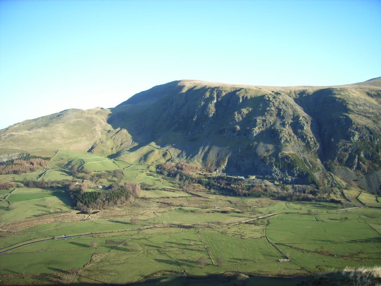
Photo: N/A
About Clough Head
A broad, grassy fell at the northern end of the Helvellyn range, above Threlkeld and St John's in the Vale. It has several ways up, and long views north to Blencathra and the Solway Firth.
Clough Head closes the Helvellyn range at its northern end. At 726 m it is the lowest summit on the main ridge. It stands above Threlkeld and the A66, and its west side is the steep east wall of St John's in the Vale.
The easiest way up uses the Old Coach Road, a rough stony track that crosses the fell's northern slopes between Wanthwaite in St John's in the Vale and High Row above Dockray. Park near either end, or take the lane south from Threlkeld towards Newsham. A narrow path leaves the Old Coach Road and climbs steeply to the rocks of White Pike, then on to the top. A more direct line goes up the steep, rough and rocky Red Screes from Threlkeld Knotts, a rounded hill of granite below the north face. The scree is loose and slippery, especially going down.
The west face is all crag and ravine: Buck Castle, Wanthwaite Crags and Bram Crag. Fisher's Wife's Rake climbs through them and is very steep. Sandbed Gill, below the north face, is a scramble for people with rope and climbing experience, not a walkers' route.
The summit has an Ordnance Survey trig column and a wind shelter. Blencathra fills the view north, and on a clear day you can see the Solway Firth and Morecambe Bay. Going south, a long grassy ridge leads past the rocky knoll of Calfhow Pike to Great Dodd.
Threlkeld Knotts has the remains of an Iron Age settlement on its north side, with hut circles, enclosures and around fifty cairns. Threlkeld Quarry, opened in 1870 for railway ballast, is now a museum.
In winter
The loose scree on Red Screes above Threlkeld Knotts turns treacherous with ice on it, so the gentler line by White Pike from the Old Coach Road is the better winter choice. The summit is broad and grassy, and in cloud the steep western crags above St John's in the Vale are closer than they look.
- Great Views
- Dog Friendly
Sources: Wikipedia: Clough Head, Wainwright Walking: Clough Head, Walk Lakes: The Dodds and Clough Head. Updated .
Summit
- OS grid ref
- NY 333 225
- Latitude
- 54.59365° N
- Longitude
- 3.03234° W
- Area
- Eastern Fells
Walking up Clough Head
The nearest car park on foot is Threlkeld Station, 3.7 km (2.3 miles) from the summit along mapped paths. Directions to the car park
Route from Threlkeld Station
- Distance
- 3.7 km
- 2.3 miles, one way
- Ascent
- 588 m
- Total climb to the summit
- Time up
- 1 h 39 min
- Allow 1 to 3 hours
Times use Naismith’s rule, 5 km/h on the flat plus extra time for the climb, with Langmuir’s corrections. It’s a rule of thumb for the way up only, so add stops, weather and the walk back down.
The route follows paths mapped by OpenStreetMap contributors and isn’t a guided line. Check the mountain forecast before you go and carry a map and compass.
Clough Head questions
Is Clough Head a Wainwright?
How high is Clough Head?
Where do you park for Clough Head?
How long does it take to climb Clough Head?
How hard is Clough Head?
Which Wainwrights are near Clough Head?
What is the grid reference for the summit of Clough Head?
Often walked with Clough Head
Fells people usually take in on the same day.
Clough Head in our guides
Wainwrights near Clough Head
Straight-line distance and direction from the summit.
 Great Dodd857 m2.1 km SE
 High Rigg357 m2.6 km W
 Watson's Dodd789 m3.0 km S
 Stybarrow Dodd844 m3.7 km S
 Hart Side756 m3.7 km SE
 Raven Crag461 m4.9 km SW
More in the Eastern Fells
- Helvellyn950 m
- Nethermost Pike891 m
- Catstycam890 m
- Raise883 m
- Fairfield873 m
- White Side863 m
- Dollywaggon Pike859 m
- Great Dodd857 m
- Stybarrow Dodd844 m
- Saint Sunday Crag841 m
- Hart Crag822 m
- Dove Crag792 m
- Watson's Dodd789 m
- Red Screes776 m
- Great Rigg766 m
- Hart Side756 m
- Seat Sandal737 m
- Birkhouse Moor718 m
- Sheffield Pike676 m
- High Pike [Scandale]656 m
- Middle Dodd654 m
- Little Hart Crag637 m
- Birks622 m
- Heron Pike612 m
- Hartsop above How581 m
- Great Mell Fell537 m
- High Hartsop Dodd519 m
- Low Pike508 m
- Little Mell Fell505 m
- Stone Arthur504 m
- Gowbarrow Fell481 m
- Nab Scar450 m
- Glenridding Dodd442 m
- Arnison Crag433 m
Bag Clough Head with Upfell
Reach the summit and capture Clough Head, even with no signal. It goes on your round of the 214 with its own patch.
Coming soon to theApp Store