North Western Fells · Book 6
Hindscarth
Hindscarth is a Wainwright, one of the 214 Lake District fells in Alfred Wainwright’s Pictorial Guides. At 727 m (2,385 ft) it is the 73rd highest of the 214 and the 9th highest in the North Western Fells.
- Height
- 727 m
- 2,385 ft
- Rank
- 73
- of 214
- In area
- 9
- of 29
- Difficulty
- Moderate
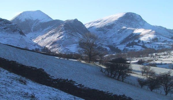
Photo: N/A
About Hindscarth
A steady ridge companion to Dale Head, with a top that surprises with space and views. The arcing traverse to Robinson is a North Western highlight.
The name comes from Old Norse and means the pass used by red deer. Hindscarth stands between Little Dale and the head of Newlands, on a spur pushed north off the main ridge from Robinson to Dale Head. The ridge path between those two skips the summit, so you have to go out of your way to stand on it.
Scope End, the north ridge above Little Town, is the favourite way up. There is a small parking area at Chapel Bridge, where the farmer takes a small fee. Walk past Newlands church to the end of the road at Low High Snab, cross Newlands Beck by the footbridge and climb onto Scope End. The lower ridge is narrow and knotted, clad in heather and bilberry, with many short rock steps near the bottom and a short, airy terrace above High Crags. None of it is exposed. Higher up, rough zigzags lead onto the summit plateau. Walk Lakes' Scope horseshoe goes up Robinson and comes down this ridge, 11.3km with 795m of ascent.
The top is grass and gravel around a scruffy cairn, with a much bigger cairn, marked as a shelter on OS maps, about 100 yards south. The view north down Newlands to Skiddaw is excellent, and of the major fell groups only High Street is out of sight.
At the foot of Scope End is Goldscope, one of the best known old mines in the Lake District. German miners worked its lead and copper from 1564, and Elizabeth I took it for the Crown from the Earl of Northumberland. The shaft went so deep that pumping it dry stopped paying, and it closed at the end of the 19th century. English Heritage counts it among the most important mining sites in the country.
In winter
Hindscarth Edge and Littledale Edge are narrow and catch the wind. The many short rock steps at the foot of Scope End turn slick when wet or icy, and Walk Lakes advise against this ridge in wet or windy weather.
- Ridge Walk
- Great Views
- Dog Friendly
Sources: Wikipedia: Hindscarth, Walk Lakes: Robinson and Hindscarth from Little Town. Updated .
Summit
- OS grid ref
- NY 215 165
- Latitude
- 54.53781° N
- Longitude
- 3.21373° W
Walking up Hindscarth
The nearest car park on foot is Chapel Bridge Car Park, 4.2 km (2.6 miles) from the summit along mapped paths. Directions to the car park
Route from Chapel Bridge Car Park
- Distance
- 4.2 km
- 2.6 miles, one way
- Ascent
- 592 m
- Total climb to the summit
- Time up
- 1 h 44 min
- Allow 1 to 3 hours
Times use Naismith’s rule, 5 km/h on the flat plus extra time for the climb, with Langmuir’s corrections. It’s a rule of thumb for the way up only, so add stops, weather and the walk back down.
The route follows paths mapped by OpenStreetMap contributors and isn’t a guided line. This car park was picked automatically and hasn’t been checked by hand yet, so compare it with a map. Check the mountain forecast before you go and carry a map and compass.
Hindscarth questions
Is Hindscarth a Wainwright?
How high is Hindscarth?
Where do you park for Hindscarth?
How long does it take to climb Hindscarth?
How hard is Hindscarth?
Which Wainwrights are near Hindscarth?
What is the grid reference for the summit of Hindscarth?
Often walked with Hindscarth
Fells people usually take in on the same day.
Hindscarth in our guides
Wainwrights near Hindscarth
Straight-line distance and direction from the summit.
 Dale Head753 m1.4 km SE
 Robinson737 m1.4 km W
 High Spy653 m1.9 km E
 Fleetwith Pike649 m2.5 km S
 Maiden Moor575 m2.7 km NE
 Knott Rigg556 m3.0 km NW
More in the North Western Fells
- Grasmoor852 m
- Eel Crag (Crag Hill)839 m
- Grisedale Pike791 m
- Wandope774 m
- Sail773 m
- Hopegill Head770 m
- Dale Head753 m
- Robinson737 m
- Whiteside (west top)707 m
- Scar Crags672 m
- Whiteless Pike660 m
- High Spy653 m
- Causey Pike637 m
- Ard Crags581 m
- Maiden Moor575 m
- Outerside568 m
- Knott Rigg556 m
- Lord's Seat552 m
- Whinlatter (Brown How)517 m
- Broom Fell511 m
- Barf469 m
- Barrow455 m
- Graystones452 m
- Catbells451 m
- Ling Fell373 m
- Sale Fell359 m
- Rannerdale Knotts355 m
- Castle Crag290 m
Bag Hindscarth with Upfell
Reach the summit and capture Hindscarth, even with no signal. It goes on your round of the 214 with its own patch.
Coming soon to theApp Store