North Western Fells · Book 6
Catbells
Catbells is a Wainwright, one of the 214 Lake District fells in Alfred Wainwright’s Pictorial Guides. At 451 m (1,480 ft) it is the 189th highest of the 214 and the 25th highest in the North Western Fells.
- Height
- 451 m
- 1,480 ft
- Rank
- 189
- of 214
- In area
- 25
- of 29
- Difficulty
- Easy
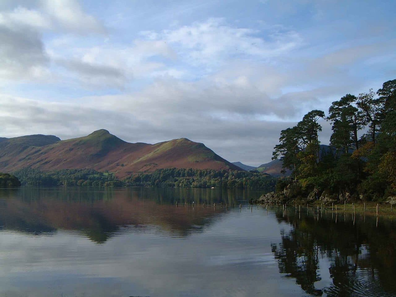
Photo: Mick Knapton via Wikimedia Commons
About Catbells
The classic family ridge above Derwentwater. Little hands love the playful rock steps, and the view takes in Borrowdale, Skiddaw and the Newlands fells in one sweep. Busy for good reason.
Catbells is best climbed by its north ridge from Hawse End, on the west shore of Derwentwater. The small roadside parking there is full early on most fine days, and there is another small car park at Gutherscale, between Hawse End and Skelgill. Leaving the car in Keswick is often easier: the Keswick Launch calls at the Hawse End jetty, and the Honister Rambler bus has a Catbells stop.
The path zigzags up to a memorial stone for Thomas Arthur Leonard, a pioneer of outdoor holidays, and carries on over the first top, Skelgill Bank. Just below the summit the ridge turns into a band of bare rock. Paths wind up it on easy-angled steps with good holds, and this is the only place you might use your hands. Most people then go on south to Hause Gate, the col below Maiden Moor, and down a steep stepped path to the old terrace road back to Hawse End.
The Newlands side is quieter. From Little Town and the small car park at Chapel Bridge, a path climbs east to Hause Gate, and the view opens out all at once as you reach the col.
The summit is a small knot of rock and loose stones between low outcrops. Derwentwater fills the view, with Keswick, Skiddaw and Bassenthwaite Lake to the north, Newlands to the west and Borrowdale to the south.
Beatrix Potter put Mrs Tiggy-Winkle's home on these slopes. There are old lead mines on both flanks, Yewthwaite above Newlands and Brandlehow above the lake. All of them had closed by the 1890s. Keep clear of their spoil and shafts.
In winter
The rock steps just below the summit are polished by boots all year and are the first part of the ridge to ice up. They are harder to go down than up, so in frost it is often easier to descend by the engineered steps at Hause Gate than back towards Skelgill Bank.
- Ridge Walk
- Great Views
- Popular
- Kid Friendly
- Family Walk
- Dog Friendly
Sources: Wikipedia: Cat Bells, Walk Lakes: Catbells. Updated .
Summit
- OS grid ref
- NY 244 198
- Latitude
- 54.56830° N
- Longitude
- 3.17068° W
Walking up Catbells
The nearest car park on foot is Chapel Bridge Car Park, 2.1 km (1.3 miles) from the summit along mapped paths. Directions to the car park
Route from Chapel Bridge Car Park
- Distance
- 2.1 km
- 1.3 miles, one way
- Ascent
- 314 m
- Total climb to the summit
- Time up
- 54 min
- Allow 1 to 2 hours
Times use Naismith’s rule, 5 km/h on the flat plus extra time for the climb, with Langmuir’s corrections. It’s a rule of thumb for the way up only, so add stops, weather and the walk back down.
The route follows paths mapped by OpenStreetMap contributors and isn’t a guided line. Check the mountain forecast before you go and carry a map and compass.
Catbells questions
Is Catbells a Wainwright?
How high is Catbells?
Where do you park for Catbells?
How long does it take to climb Catbells?
How hard is Catbells?
Which Wainwrights are near Catbells?
What is the grid reference for the summit of Catbells?
Often walked with Catbells
Fells people usually take in on the same day.

Catbells in our guides
- The Newlands Horseshoe: six Wainwrights around the Newlands valley
- Wainwright scrambles: the edges, rakes and bad steps
- Wainwrights by bus: the Lake District without a car
- Wainwrights for beginners: a first-timer's guide
- Wainwrights for kids: easy fells for children
- Wainwrights from Borrowdale
- Wainwrights from Keswick
- Wainwrights with the best views
Wainwrights near Catbells
Straight-line distance and direction from the summit.
 Maiden Moor575 m1.8 km SW
 Barrow455 m2.6 km NW
 Causey Pike637 m2.7 km W
 Walla Crag379 m3.6 km NE
 Outerside568 m3.7 km NW
 Ard Crags581 m3.7 km W
More in the North Western Fells
- Grasmoor852 m
- Eel Crag (Crag Hill)839 m
- Grisedale Pike791 m
- Wandope774 m
- Sail773 m
- Hopegill Head770 m
- Dale Head753 m
- Robinson737 m
- Hindscarth727 m
- Whiteside (west top)707 m
- Scar Crags672 m
- Whiteless Pike660 m
- High Spy653 m
- Causey Pike637 m
- Ard Crags581 m
- Maiden Moor575 m
- Outerside568 m
- Knott Rigg556 m
- Lord's Seat552 m
- Whinlatter (Brown How)517 m
- Broom Fell511 m
- Barf469 m
- Barrow455 m
- Graystones452 m
- Ling Fell373 m
- Sale Fell359 m
- Rannerdale Knotts355 m
- Castle Crag290 m
Bag Catbells with Upfell
Reach the summit and capture Catbells, even with no signal. It goes on your round of the 214 with its own patch.
Coming soon to theApp Store