North Western Fells · Book 6
Sail
Sail is a Wainwright, one of the 214 Lake District fells in Alfred Wainwright’s Pictorial Guides. At 773 m (2,536 ft) it is the joint 51st highest of the 214 and the 5th highest in the North Western Fells.
- Height
- 773 m
- 2,536 ft
- Rank
- =51
- of 214
- In area
- 5
- of 29
- Difficulty
- Moderate
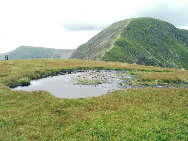
Photo: Nigel Davies via Geograph, CC BY-SA 2.0
About Sail
A North Western height on the Coledale skyline, between Crag Hill and Scar Crags. A heathery dome with steep, craggy flanks, looking down Coledale and across to Helvellyn. Usually taken in on the ridge between Causey Pike and Grasmoor.
Sail sits in the middle of the ridge from Causey Pike to Grasmoor, between Scar Crags and Crag Hill. Its slopes are steep and rough, but its top is a rounded dome of heather. It stands on the main watershed of the North Western Fells, which Grasmoor does not, with Coledale draining north to the Derwent and Sail Beck running south to Buttermere.
Most walkers cross it on a ridge traverse or on the Coledale Horseshoe from Braithwaite. For a direct ascent from Stair in Newlands, the old Stonycroft mine road climbs to Sail Pass, the col with Scar Crags, and from there a raised, badly eroded path zigzags up the east side. From Braithwaite, head for High Coledale Farm and cross the Outerside ridge near Stile End to reach the pass from the north. From Buttermere a long walk up Sail Beck behind Ard Crags reaches it from the south.
Westward, the ridge to Crag Hill narrows over The Scar, a rocky crest with Scott Crag on the Coledale side and Scar Crag above Sail Beck. The path keeps to the crest and has a couple of easy rock steps. Nothing is exposed.
The main path misses the summit by a few paces. The small cairn stands just off it across the grass and often sits in a puddle. The head of Coledale lies below to the north, the Helvellyn range stretches out beyond Catbells, and the high fells around Wasdale and Eskdale fill the south. Bassenthwaite Lake is in view, and a few steps bring in Buttermere and Derwentwater.
On the north side of Sail Pass are the levels of a cobalt mine opened in the 1840s. The vein turned out to hold far more arsenic than cobalt, and the venture was soon abandoned.
In winter
The Scar, the narrow rocky crest between Sail and Crag Hill, has crags on both sides and a few rock steps that ice over. The eroded zigzag path up Sail's east side from Sail Pass is slippery when frozen.
- Great Views
- Dog Friendly
Sources: Wikipedia: Sail, Walk Lakes: A Shorter Coledale Round, Walk Lakes: The Coledale Horseshoe. Updated .
Summit
- OS grid ref
- NY 198 202
- Latitude
- 54.57137° N
- Longitude
- 3.24174° W
Walking up Sail
The nearest car park on foot is Stoneycroft Ghyll, 5.0 km (3.1 miles) from the summit along mapped paths. Directions to the car park
Route from Stoneycroft Ghyll
- Distance
- 5.0 km
- 3.1 miles, one way
- Ascent
- 706 m
- Total climb to the summit
- Time up
- 2 h 5 min
- Allow 1 to 3 hours
Times use Naismith’s rule, 5 km/h on the flat plus extra time for the climb, with Langmuir’s corrections. It’s a rule of thumb for the way up only, so add stops, weather and the walk back down.
The route follows paths mapped by OpenStreetMap contributors and isn’t a guided line. This car park was picked automatically and hasn’t been checked by hand yet, so compare it with a map. Check the mountain forecast before you go and carry a map and compass.
Sail questions
Is Sail a Wainwright?
How high is Sail?
Where do you park for Sail?
How long does it take to climb Sail?
How hard is Sail?
Which Wainwrights are near Sail?
What is the grid reference for the summit of Sail?
Often walked with Sail
Fells people usually take in on the same day.
Sail in our guides
Wainwrights near Sail
Straight-line distance and direction from the summit.
 Eel Crag (Crag Hill)839 m0.6 km W
 Scar Crags672 m1.0 km E
 Ard Crags581 m1.0 km SE
 Wandope774 m1.1 km SW
 Knott Rigg556 m1.4 km S
 Outerside568 m1.7 km NE
More in the North Western Fells
- Grasmoor852 m
- Eel Crag (Crag Hill)839 m
- Grisedale Pike791 m
- Wandope774 m
- Hopegill Head770 m
- Dale Head753 m
- Robinson737 m
- Hindscarth727 m
- Whiteside (west top)707 m
- Scar Crags672 m
- Whiteless Pike660 m
- High Spy653 m
- Causey Pike637 m
- Ard Crags581 m
- Maiden Moor575 m
- Outerside568 m
- Knott Rigg556 m
- Lord's Seat552 m
- Whinlatter (Brown How)517 m
- Broom Fell511 m
- Barf469 m
- Barrow455 m
- Graystones452 m
- Catbells451 m
- Ling Fell373 m
- Sale Fell359 m
- Rannerdale Knotts355 m
- Castle Crag290 m
Bag Sail with Upfell
Reach the summit and capture Sail, even with no signal. It goes on your round of the 214 with its own patch.
Coming soon to theApp Store