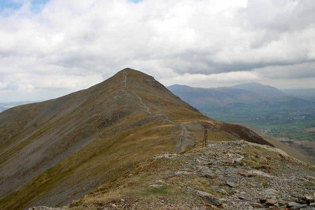
Coledale is the valley that runs west from Braithwaite to Force Crag Mine, and the fells around it make one of the best bagging days in the North Western Fells. There are two common versions. The WalkLakes Coledale Horseshoe bags five Wainwrights: Grisedale Pike, Hopegill Head, Crag Hill, Sail and Outerside. It measures 15.0 km with 1,178 m of ascent and a minimum walking time of 4 hours 58 minutes. The Coledale Round, as Wikipedia describes it, swaps Outerside for Scar Crags and Causey Pike. That makes six, at about 17.5 km with over 1,300 m of ascent.
The bagging opportunity is what sits just off the line. Grasmoor, the highest fell in the North Western Fells at 852 m, is a detour from the col the route crosses below Crag Hill. Whiteside is along the ridge west from Hopegill Head. Barrow rises straight out of Braithwaite.
The Coledale fells, in walking order from Grisedale Pike
| Rank | Fell | Height | Area | Difficulty |
|---|---|---|---|---|
| 40 | Grisedale PikeNorth Western Fells | 791 m | North Western Fells | Difficult |
| 53 | Hopegill HeadNorth Western Fells | 770 m | North Western Fells | Moderate |
| 24 | Eel Crag (Crag Hill)North Western Fells | 839 m | North Western Fells | Moderate |
| =51 | SailNorth Western Fells | 773 m | North Western Fells | Moderate |
| 102 | Scar CragsNorth Western Fells | 672 m | North Western Fells | Moderate |
| =119 | Causey PikeNorth Western Fells | 637 m | North Western Fells | Moderate |
| 142 | OutersideNorth Western Fells | 568 m | North Western Fells | Moderate |
Where to start and park
Braithwaite is the start for both versions. WalkLakes uses the small car park on the Whinlatter road just above the village, at the start of the track to Force Crag Mine. It holds about a dozen cars. The same small parking area, opposite the Hope Memorial Camp, is where the Grisedale Pike path begins, and it fills quickly. There is street parking in the village, and in the summer holidays the village school has opened its grounds to walkers for a small fee.
The Coledale Round can also start from Stair in Newlands. There is a large informal parking area on the Newlands road above Uzzicar Farm, at the foot of the old mine track up Stonycroft Gill, with more space by the bridge over Stoneycroft Gill. This is the place to start if Causey Pike is the fell you most want.
Which way round
WalkLakes goes anticlockwise: up the east ridge of Grisedale Pike first, west along the north side of the valley, then back east along the south side. Going this way, the steep, loose and stony section on Sleet How, below Grisedale Pike's summit, is a climb rather than a descent. You also come down The Scar from Crag Hill rather than up it.
On the Coledale Round from Braithwaite, the same direction finishes over Scar Crags and the knobbly crest of Causey Pike, then down Rowling End to the Newlands road, a little under 2 km from Braithwaite. Walked the other way, the Causey Pike scramble comes first, and you go up it rather than down. Scrambles are generally easier to climb than to reverse, so if the Causey Pike rock worries you, start with it.
The tricky bits
- Sleet How. The ridge up Grisedale Pike narrows beyond Sleet How, and the last pull is a rough clamber over loose stones and rock steps. You will use your hands now and then, but there is no real exposure.
- Hobcarton Crag. Between Grisedale Pike and Hopegill Head the path follows the edge of Hobcarton Crag. Where the crag turns sheer, stay on the main path a little away from the edge.
- Coledale Hause and Crag Hill. From the hause, Eel Crag is steep boulder scree and rock, and no place for walkers. The path turns the crags to the west, climbs beside a stream to the col with Grasmoor, then goes up a wide path to Crag Hill's battered trig pillar.
- The Scar. East of Crag Hill the ridge to Sail narrows into a rocky crest with a couple of easy rock steps. Nothing is exposed.
- The terrace below Scar Crags. The WalkLakes route follows an airy terrace path across the northern face of Scar Crags and doesn't cross its summit. If you want the tick, stay on the ridge instead.
- Sail's summit. The main path misses the top by a few paces, and the small cairn stands just off it across the grass.
- Underfoot. WalkLakes rates the route challenging, with boggy ground in places and thick bracken on the lower paths.
Adding Grasmoor and Whiteside
For a bagger, Grasmoor is the obvious add. From Coledale Hause the path to Crag Hill climbs to the col between Crag Hill and Grasmoor, so Grasmoor is an out-and-back west along the broad ridge from there. Its summit is at the western end of a gently domed plateau, under a big cairn and wind shelter.
Whiteside is an out-and-back from Hopegill Head. The ridge between them has crags on one side and grass on the other, and in places the path drops just below the crest to miss a rocky step. It is not a scramble. Both add height and distance that we can't give a sourced figure for, so plan for a longer day than the numbers above.
Escape routes
- Coledale Hause is the main one. From the hause a path drops into Coledale and follows the valley past Force Crag Mine to the old mine road and back to Braithwaite. WalkLakes uses this line for its Grisedale Pike and Hopegill Head loop, 13 km with 875 m of ascent.
- Sail Pass, between Sail and Scar Crags. The Stonycroft mine road goes down to Stair, and paths north past Outerside lead back to Braithwaite.
- Before Grisedale Pike, you can simply turn back down the east ridge.
Shorter ways to bag the same fells
- Grisedale Pike and Hopegill Head. The WalkLakes loop returns by Sand Hill, Coledale Hause and the valley: 13 km with 875 m of ascent.
- Barrow, Outerside, Sail and Crag Hill. The WalkLakes shorter Coledale round is 14.9 km with 1,001 m of ascent, a minimum of 4 hours 39 minutes, and it adds Barrow.
- Causey Pike and Scar Crags. The WalkLakes loop from above Uzzicar Farm goes up Rowling End, over both tops and back down the Stonycroft mine track: 8.3 km with 609 m of ascent.
- Grasmoor and Whiteside from Crummock Water. The WalkLakes Grasmoor Six starts at Lanthwaite Green (NY 158 208).
Wainwrights to add to a Coledale round

Getting there by bus
Braithwaite is well served. The Stagecoach summer 2026 timetable (23 March to 1 November) lists:
- X5 between Keswick, Braithwaite, Cockermouth and Workington, Monday to Saturday
- 77 and 77A Honister Rambler, the circular Keswick service that calls at Braithwaite, Whinlatter, Buttermere, Honister and Borrowdale
The Honister Rambler also stops at Lanthwaite Green Farm, the start for Grasmoor and Whiteside from the Crummock side. For more car-free rounds, see Wainwrights by bus.
How it fits a Wainwright round
Coledale is the middle of the North Western Fells, and a round here leaves you with clean edges. The Newlands fells to the south are covered by the Newlands Horseshoe, and the Whinlatter fells to the north are a separate outing from the top of the pass. If you stay in Braithwaite, the Braithwaite guide covers the rest from the village, and the Keswick guide covers the town. For more rounds that bag a string of summits, see Wainwright ridge walks.
Take a map and compass. Coledale Hause is a broad grassy col, and in cloud it is easy to leave it on the wrong line. Check the Mountain Weather Information Service (MWIS) forecast first. Upfell is a free iPhone app that keeps your list of bagged fells for you.