North Western Fells · Book 6
Hopegill Head
Hopegill Head is a Wainwright, one of the 214 Lake District fells in Alfred Wainwright’s Pictorial Guides. At 770 m (2,526 ft) it is the 53rd highest of the 214 and the 6th highest in the North Western Fells.
- Height
- 770 m
- 2,526 ft
- Rank
- 53
- of 214
- In area
- 6
- of 29
- Difficulty
- Moderate
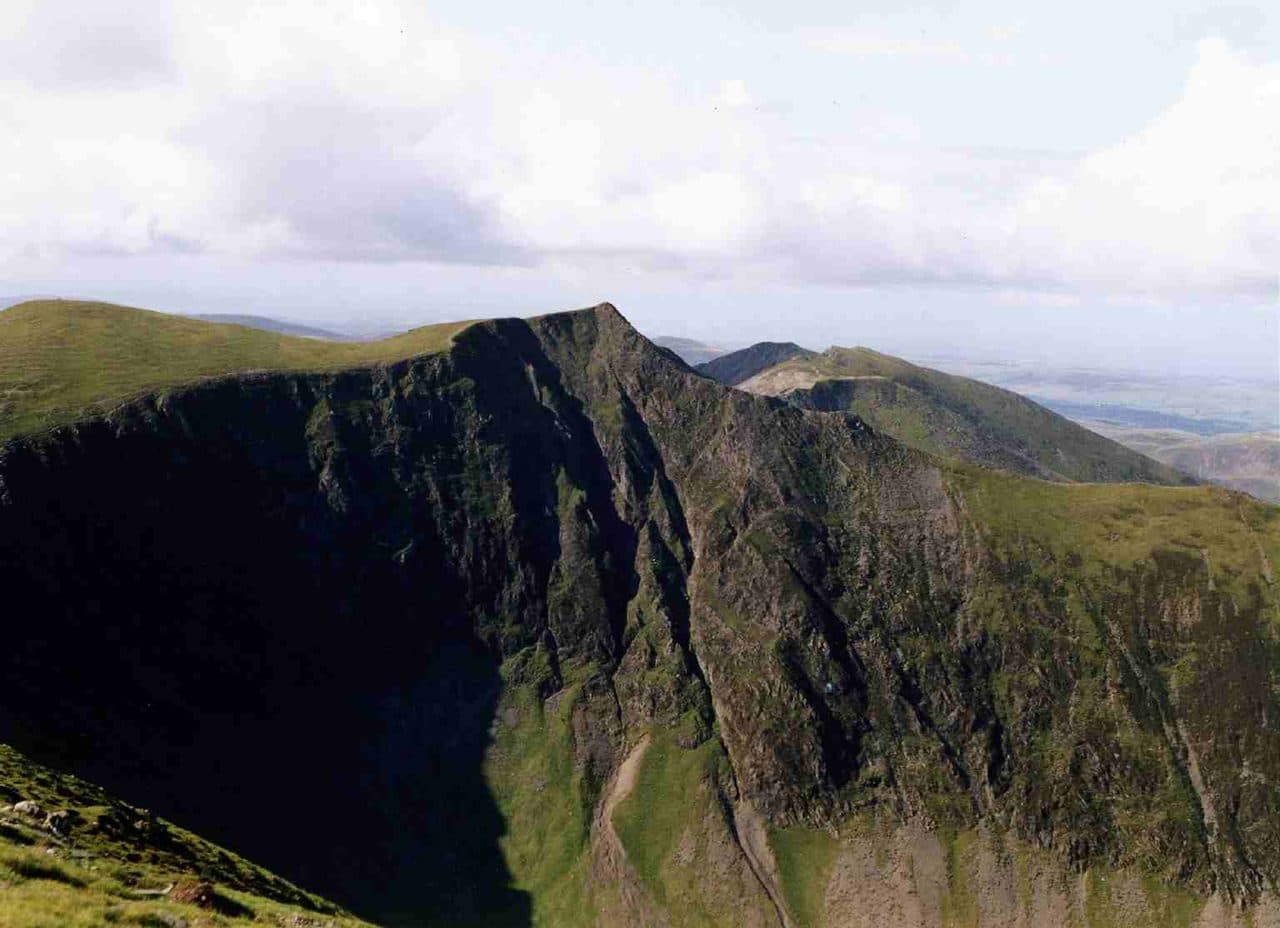
Photo: Mick Knapton via Wikimedia Commons
About Hopegill Head
A shapely peak that anchors the Coledale skyline. The ridge to Whiteside is airy and memorable, while crags bite steeply into Hobcarton. A superb half-day with lots of ridge drama for modest effort.
Perched on the edge of Hobcarton Crag, which drops about 130m to Hobcarton Gill, the summit of Hopegill Head is a small rocky point. Some locals call it Hobcarton Pike. It is the middle one of three fells on the ridge from Braithwaite to Crummock Water, with Grisedale Pike to the east and Whiteside to the west.
Most walks come from Braithwaite over Grisedale Pike. Park in the small area near the foot of the Whinlatter road, opposite Hope Memorial Camp, or on the street in the village. Climb Grisedale Pike's east ridge, follow the old fence posts south-west and keep along the edge of Hobcarton Crag to the top. Where the crags turn sheer, stay on the main path a little away from the edge. The return crosses Sand Hill to Coledale Hause and follows the valley past Force Crag Mine to the mine road, 13km with 875m of ascent. From the west, walkers climb Whiteside from Lanthwaite Green and follow the narrow ridge across. The quieter north-west ridge over Ladyside Pike starts from the Whinlatter Pass road.
The Whiteside ridge has crags on one side and grass on the other, and in places the path drops just below the crest to miss a rocky step. There is rough clambering on the last pull up Grisedale Pike, but none of these routes is a scramble.
The Isle of Man and the Scottish border hills show on clear days, and the Helvellyn range lines the east.
Hobcarton Crag is the only place in England where the red alpine catchfly grows. Its crumbly Skiddaw slate is no good for summer rock climbing, but in winter climbers use it for routes such as Thompson's Chimney and Cave Route.
In winter
The summit sits on the lip of Hobcarton Crag, a cliff of about 130m, so in snow keep to the wider path set back from the edge. The final climb up Grisedale Pike on the usual approach is loose stones and rock steps that are hard work when icy.
- Ridge Walk
- Great Views
- Dog Friendly
Sources: Wikipedia: Hopegill Head, Walk Lakes: Grisedale Pike and Hopegill Head, Walk Lakes: The Grasmoor Six Wainwright Fells. Updated .
Summit
- OS grid ref
- NY 185 221
- Latitude
- 54.58807° N
- Longitude
- 3.26163° W
Walking up Hopegill Head
The nearest car park on foot is Hobcarton, 5.3 km (3.3 miles) from the summit along mapped paths. Directions to the car park
Route from Hobcarton
- Distance
- 5.3 km
- 3.3 miles, one way
- Ascent
- 649 m
- Total climb to the summit
- Time up
- 2 h 3 min
- Allow 1 to 3 hours
Times use Naismith’s rule, 5 km/h on the flat plus extra time for the climb, with Langmuir’s corrections. It’s a rule of thumb for the way up only, so add stops, weather and the walk back down.
The route follows paths mapped by OpenStreetMap contributors and isn’t a guided line. Check the mountain forecast before you go and carry a map and compass.
Hopegill Head questions
Is Hopegill Head a Wainwright?
How high is Hopegill Head?
Where do you park for Hopegill Head?
How long does it take to climb Hopegill Head?
How hard is Hopegill Head?
Which Wainwrights are near Hopegill Head?
What is the grid reference for the summit of Hopegill Head?
Often walked with Hopegill Head
Fells people usually take in on the same day.
Hopegill Head in our guides
Wainwrights near Hopegill Head
Straight-line distance and direction from the summit.
 Grisedale Pike791 m1.3 km E
 Whiteside (west top)707 m1.5 km W
 Eel Crag (Crag Hill)839 m1.9 km S
 Grasmoor852 m2.1 km SW
 Sail773 m2.3 km SE
 Wandope774 m2.4 km S
More in the North Western Fells
- Grasmoor852 m
- Eel Crag (Crag Hill)839 m
- Grisedale Pike791 m
- Wandope774 m
- Sail773 m
- Dale Head753 m
- Robinson737 m
- Hindscarth727 m
- Whiteside (west top)707 m
- Scar Crags672 m
- Whiteless Pike660 m
- High Spy653 m
- Causey Pike637 m
- Ard Crags581 m
- Maiden Moor575 m
- Outerside568 m
- Knott Rigg556 m
- Lord's Seat552 m
- Whinlatter (Brown How)517 m
- Broom Fell511 m
- Barf469 m
- Barrow455 m
- Graystones452 m
- Catbells451 m
- Ling Fell373 m
- Sale Fell359 m
- Rannerdale Knotts355 m
- Castle Crag290 m
Bag Hopegill Head with Upfell
Reach the summit and capture Hopegill Head, even with no signal. It goes on your round of the 214 with its own patch.
Coming soon to theApp Store