North Western Fells · Book 6
Rannerdale Knotts
Rannerdale Knotts is a Wainwright, one of the 214 Lake District fells in Alfred Wainwright’s Pictorial Guides. At 355 m (1,165 ft) it is the 210th highest of the 214 and the 28th highest in the North Western Fells.
- Height
- 355 m
- 1,165 ft
- Rank
- 210
- of 214
- In area
- 28
- of 29
- Difficulty
- Moderate
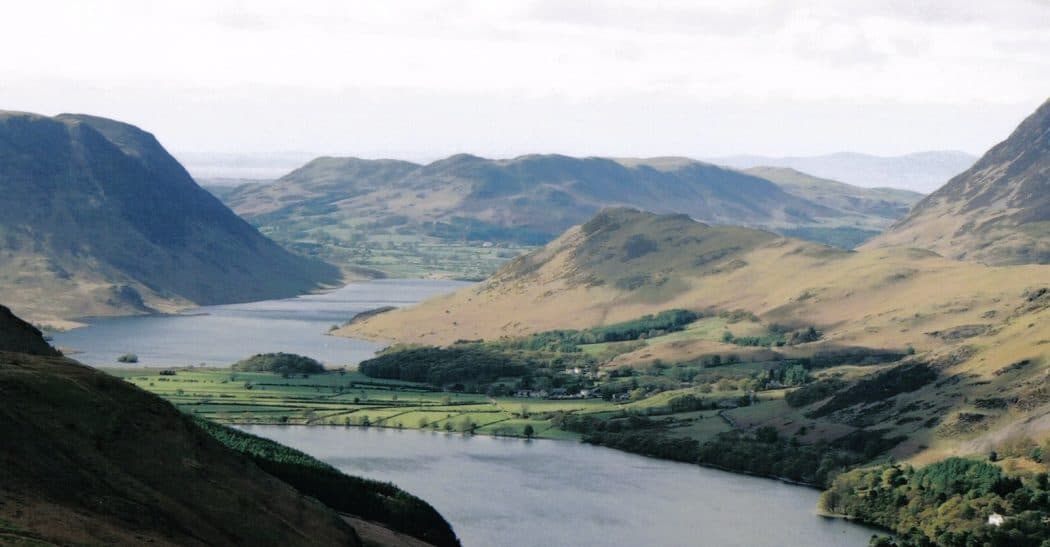
Photo: Archie424 via Wikimedia Commons
About Rannerdale Knotts
A small fell with a big personality, rising sharply above Crummock Water. Steeper steps and rocky knolls give a mini‑mountain feel. In spring the valley is famous for its bluebells, so expect company.
For the nearest parking, use the B5289 beside Crummock Water. Cinderdale Common has free roadside spaces a short walk from the foot of the fell, and there is a small free National Trust area at Hause Point that holds about eight cars. Otherwise start from Buttermere village, which has pay car parks, including one behind the Bridge Hotel, and a seasonal bus from Keswick.
From Buttermere the walk goes through Ghyll Wood and up beside Mill Beck on the path towards Whiteless Pike. At the col, roughly 290m up, turn west along Low Bank and follow the crest to the summit. From Cinderdale the path heads up the side valley beside Squat Beck to the same col. Coming down the western end, a pitched stone path winds through the crags to the old bridleway that was once the road between Lorton and Buttermere. Expect steep grass, rough paths and a few moments with hands on rock around the top, though nothing serious.
The summit is the highest of several rocky knolls and carries a cairn. Higher fells crowd round it to the east, but the view the other way is excellent. Buttermere lies along the valley with Great Gable at its head, and a few steps west bring Crummock Water into sight directly below.
Bluebells
The side valley east of the fell is covered in bluebells from late April, usually at their best around mid May. Local legend says they grew from the blood of Norman soldiers beaten here by the native Cumbrians, a story made popular by Nicholas Size's 1930 novel The Secret Valley. The battle is almost certainly legend, but the flowers are real and fragile. Keep to the marked paths, because a trampled plant takes years to recover.
In winter
Snow rarely lasts at this height, but the stone-pitched descent through the crags at the western end and the rocky steps near the summit are slippery with ice or wet leaves. Being low, it makes a sensible short day when the higher Buttermere fells are in cloud.
- Popular
- Family Walk
- Dog Friendly
Sources: Wikipedia: Rannerdale Knotts, Walk Lakes: Rannerdale Knotts from Buttermere, Conversant Traveller: Rannerdale bluebells, parking and walks. Updated .
Summit
- OS grid ref
- NY 167 182
- Latitude
- 54.55263° N
- Longitude
- 3.28901° W
Walking up Rannerdale Knotts
The nearest car park on foot is Lanthwaite Wood National Trust car park, 4.3 km (2.7 miles) from the summit along mapped paths. Directions to the car park
Route from Lanthwaite Wood National Trust car park
- Distance
- 4.3 km
- 2.7 miles, one way
- Ascent
- 279 m
- Total climb to the summit
- Time up
- 1 h 17 min
- Allow 1 to 2 hours
Times use Naismith’s rule, 5 km/h on the flat plus extra time for the climb, with Langmuir’s corrections. It’s a rule of thumb for the way up only, so add stops, weather and the walk back down.
The route follows paths mapped by OpenStreetMap contributors and isn’t a guided line. Check the mountain forecast before you go and carry a map and compass.
Rannerdale Knotts questions
Is Rannerdale Knotts a Wainwright?
How high is Rannerdale Knotts?
Where do you park for Rannerdale Knotts?
How long does it take to climb Rannerdale Knotts?
How hard is Rannerdale Knotts?
Which Wainwrights are near Rannerdale Knotts?
What is the grid reference for the summit of Rannerdale Knotts?
Often walked with Rannerdale Knotts
Fells people usually take in on the same day.
Rannerdale Knotts in our guides
Wainwrights near Rannerdale Knotts
Straight-line distance and direction from the summit.
 Whiteless Pike660 m1.5 km NE
 Mellbreak (south top)512 m1.9 km W
 Grasmoor852 m2.2 km N
 Wandope774 m2.6 km NE
 Red Pike [Buttermere]755 m2.9 km S
 Knott Rigg556 m3.1 km E
More in the North Western Fells
- Grasmoor852 m
- Eel Crag (Crag Hill)839 m
- Grisedale Pike791 m
- Wandope774 m
- Sail773 m
- Hopegill Head770 m
- Dale Head753 m
- Robinson737 m
- Hindscarth727 m
- Whiteside (west top)707 m
- Scar Crags672 m
- Whiteless Pike660 m
- High Spy653 m
- Causey Pike637 m
- Ard Crags581 m
- Maiden Moor575 m
- Outerside568 m
- Knott Rigg556 m
- Lord's Seat552 m
- Whinlatter (Brown How)517 m
- Broom Fell511 m
- Barf469 m
- Barrow455 m
- Graystones452 m
- Catbells451 m
- Ling Fell373 m
- Sale Fell359 m
- Castle Crag290 m
Bag Rannerdale Knotts with Upfell
Reach the summit and capture Rannerdale Knotts, even with no signal. It goes on your round of the 214 with its own patch.
Coming soon to theApp Store