Western Fells · Book 7
Mellbreak (south top)
Mellbreak (south top) is a Wainwright, one of the 214 Lake District fells in Alfred Wainwright’s Pictorial Guides. At 512 m (1,680 ft) it is the 168th highest of the 214 and the 27th highest in the Western Fells.
- Height
- 512 m
- 1,680 ft
- Rank
- 168
- of 214
- In area
- 27
- of 33
- Difficulty
- Moderate
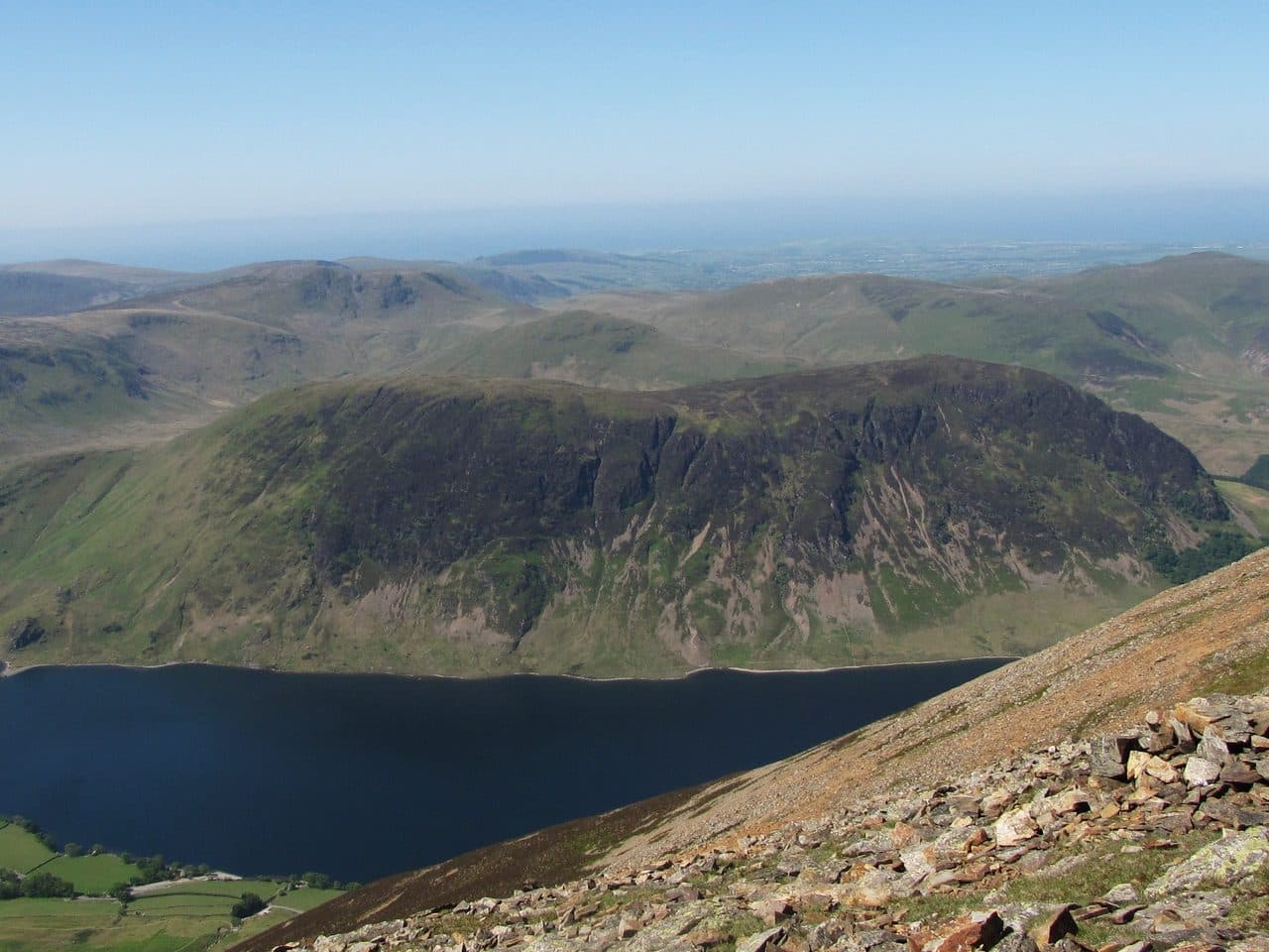
Photo: N/A
About Mellbreak (south top)
Twin summits and steep flanks above Crummock Water. Short sharp pulls, sheep tracks and sudden drama. Feels wild despite modest height.
Seen from the Kirkstile Inn at Loweswater, the north end of Mellbreak is a wall of crag and scree, and the popular way up goes straight at it. Park by the inn, at Maggie's Bridge (about ten cars) or at the larger car park at Scalehill Bridge and Lanthwaite Wood. From the inn a walled track leads to the foot of a long tongue of scree. The next kilometre averages a gradient of about 30 per cent. Take the scree head on or use the heathery bypasses to its right. All the lines meet at a gully through the crags that is full of loose stones. Above it the path eases through heather to the north top.
The two tops are almost the same height and about a kilometre apart. The north top, 509 m, is rocky and sits on the crags of the north face, and from it you can see the Solway Firth. The south top, 512 m, is the true summit, a grassy rise reached across a dip of boggy ground, knolls and tiny tarns. From either one Grasmoor and Rannerdale Knotts look big across Crummock Water.
Other ways up
One path slants south along the Mosedale face and skips the north top. From the Crummock shore, Pillar Rake climbs a diagonal break in the crags. From Buttermere village the Scale Force path leads to Scale Knott and the south top.
Walk Lakes' loop goes over both tops and down past Scale Knott to Scale Force, 52 m high and thought to be the tallest waterfall in the Lake District, then back along Crummock Water. It is 11 km with 600 m of ascent. Marshy ground surrounds the fell on three sides, and Mosedale to the west is the worst of it.
In winter
The scree tongue and the loose gully through the crags at the north end are hard going when frozen, and worse in descent. The dip between the two tops is boggy with small tarns, and the north and east crags are close to the path in mist.
- Quiet & Remote
- Potentially Dangerous
- Dog Friendly
Sources: Wikipedia: Mellbreak, Walk Lakes: Mellbreak and Scale Force, Walking Englishman: Mellbreak, Hen Comb, Gavel Fell, Blake Fell and Burnbank Fell. Updated .
Summit
- OS grid ref
- NY 148 186
- Latitude
- 54.55556° N
- Longitude
- 3.31823° W
- Area
- Western Fells
Walking up Mellbreak (south top)
The nearest car park on foot is Kirkstile Inn Car Park, 3.3 km (2.0 miles) from the summit along mapped paths. Directions to the car park
Route from Kirkstile Inn Car Park
- Distance
- 3.3 km
- 2.0 miles, one way
- Ascent
- 453 m
- Total climb to the summit
- Time up
- 1 h 19 min
- Allow 1 to 2 hours
Times use Naismith’s rule, 5 km/h on the flat plus extra time for the climb, with Langmuir’s corrections. It’s a rule of thumb for the way up only, so add stops, weather and the walk back down.
The route follows paths mapped by OpenStreetMap contributors and isn’t a guided line. Check the mountain forecast before you go and carry a map and compass.
Mellbreak (south top) questions
Is Mellbreak (south top) a Wainwright?
How high is Mellbreak (south top)?
Where do you park for Mellbreak (south top)?
How long does it take to climb Mellbreak (south top)?
How hard is Mellbreak (south top)?
Which Wainwrights are near Mellbreak (south top)?
What is the grid reference for the summit of Mellbreak (south top)?
Often walked with Mellbreak (south top)
Fells people usually take in on the same day.
Mellbreak (south top) in our guides
Wainwrights near Mellbreak (south top)
Straight-line distance and direction from the summit.
 Hen Comb509 m1.7 km W
 Rannerdale Knotts355 m1.9 km E
 Starling Dodd633 m2.9 km S
 Gavel Fell526 m3.1 km W
 Grasmoor852 m3.2 km NE
 Whiteless Pike660 m3.2 km E
More in the Western Fells
- Great Gable899 m
- Pillar892 m
- Scoat Fell841 m
- Red Pike [Wasdale]826 m
- Steeple819 m
- High Stile806 m
- Kirk Fell802 m
- Green Gable801 m
- Haycock797 m
- Red Pike [Buttermere]755 m
- High Crag744 m
- Brandreth715 m
- Caw Fell697 m
- Grey Knotts697 m
- Seatallan692 m
- Fleetwith Pike649 m
- Base Brown646 m
- Starling Dodd633 m
- Yewbarrow627 m
- Great Borne616 m
- Haystacks597 m
- Middle Fell582 m
- Blake Fell573 m
- Lank Rigg541 m
- Gavel Fell526 m
- Crag Fell523 m
- Hen Comb509 m
- Grike488 m
- Burnbank Fell475 m
- Buckbarrow423 m
- Low Fell423 m
- Fellbarrow416 m
Bag Mellbreak (south top) with Upfell
Reach the summit and capture Mellbreak (south top), even with no signal. It goes on your round of the 214 with its own patch.
Coming soon to theApp Store