Western Fells · Book 7
High Crag
High Crag is a Wainwright, one of the 214 Lake District fells in Alfred Wainwright’s Pictorial Guides. At 744 m (2,441 ft) it is the 65th highest of the 214 and the 11th highest in the Western Fells.
- Height
- 744 m
- 2,441 ft
- Rank
- 65
- of 214
- In area
- 11
- of 33
- Difficulty
- Difficult
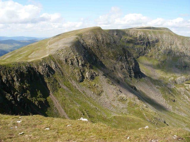
Photo: Peter Wormald via Geograph, CC BY-SA 2.0
About High Crag
Steep and stony with short scrambly pitches, linking beautifully with High Stile and Red Pike. The drop to Comb Crags gives real edge-of-the-world feels.
The summit cairn sits at the top of Gamlin End, a long slope of scree that falls about 700 feet, and the path from Buttermere climbs it in zigzags. Park at Gatesgarth Farm, at the head of the lake; the Honister Rambler bus (77) runs along the valley road in season. Cross the flat valley floor and climb to Scarth Gap, the pass between High Crag and Haystacks. Near the top of the pass a path cuts the corner below Seat, a rocky knoll of 560 m, and then the steep part begins. The lower zigzags are pitched, and higher up the path is eroded and loose. It is easier on the right. There is no scrambling, just a steady, loose climb.
The other way up is from Birkness Comb (also spelt Burtness), the hollow between High Crag and High Stile, where a grassy rake finds a way through the crags. Scarth Gap can be reached from Ennerdale too, but it is a long walk unless you are staying at Black Sail youth hostel.
Along the edge
From the top, old iron fence posts lead along the crags to High Stile and on to Red Pike, and most people walk the three together as the Buttermere ridge. Walk Lakes starts its version in Buttermere village, goes over Seat and High Crag first, and comes down past Bleaberry Tarn and Sourmilk Gill. It is about 13.5 km with 945 m of ascent. Water is scarce between Seat and Red Pike, so carry enough in dry weather.
You look up Ennerdale to its head with the Scafells behind, and further off to Skiddaw and the Helvellyn range. On a clear day the view along the edge reaches Scotland.
In winter
The pitched zigzags and loose scree of Gamlin End are awkward once they freeze, and worse in descent. Along the ridge the path keeps close to the top of the crags above Birkness Comb, so in mist or snow follow the line of old fence posts rather than the edge.
- Great Views
- Potentially Dangerous
Sources: Wikipedia: High Crag, Walk Lakes: The Buttermere Edge. Updated .
Summit
- OS grid ref
- NY 180 139
- Latitude
- 54.51461° N
- Longitude
- 3.26739° W
- Area
- Western Fells
Walking up High Crag
The nearest car park on foot is Gatesgarth Farm, 2.7 km (1.7 miles) from the summit along mapped paths. Directions to the car park
Route from Gatesgarth Farm
- Distance
- 2.7 km
- 1.7 miles, one way
- Ascent
- 639 m
- Total climb to the summit
- Time up
- 1 h 32 min
- Allow 1 to 2 hours
Times use Naismith’s rule, 5 km/h on the flat plus extra time for the climb, with Langmuir’s corrections. It’s a rule of thumb for the way up only, so add stops, weather and the walk back down.
The route follows paths mapped by OpenStreetMap contributors and isn’t a guided line. Check the mountain forecast before you go and carry a map and compass.
High Crag questions
Is High Crag a Wainwright?
How high is High Crag?
Where do you park for High Crag?
How long does it take to climb High Crag?
How hard is High Crag?
Which Wainwrights are near High Crag?
What is the grid reference for the summit of High Crag?
Often walked with High Crag
Fells people usually take in on the same day.
High Crag in our guides
Wainwrights near High Crag
Straight-line distance and direction from the summit.
 Haystacks597 m1.5 km SE
 High Stile806 m1.5 km NW
 Pillar892 m2.1 km SW
 Red Pike [Buttermere]755 m2.5 km NW
 Fleetwith Pike649 m2.5 km E
 Steeple819 m3.3 km SW
More in the Western Fells
- Great Gable899 m
- Pillar892 m
- Scoat Fell841 m
- Red Pike [Wasdale]826 m
- Steeple819 m
- High Stile806 m
- Kirk Fell802 m
- Green Gable801 m
- Haycock797 m
- Red Pike [Buttermere]755 m
- Brandreth715 m
- Caw Fell697 m
- Grey Knotts697 m
- Seatallan692 m
- Fleetwith Pike649 m
- Base Brown646 m
- Starling Dodd633 m
- Yewbarrow627 m
- Great Borne616 m
- Haystacks597 m
- Middle Fell582 m
- Blake Fell573 m
- Lank Rigg541 m
- Gavel Fell526 m
- Crag Fell523 m
- Mellbreak (south top)512 m
- Hen Comb509 m
- Grike488 m
- Burnbank Fell475 m
- Buckbarrow423 m
- Low Fell423 m
- Fellbarrow416 m
Bag High Crag with Upfell
Reach the summit and capture High Crag, even with no signal. It goes on your round of the 214 with its own patch.
Coming soon to theApp Store