Western Fells · Book 7
Green Gable
Green Gable is a Wainwright, one of the 214 Lake District fells in Alfred Wainwright’s Pictorial Guides. At 801 m (2,628 ft) it is the 35th highest of the 214 and the 8th highest in the Western Fells.
- Height
- 801 m
- 2,628 ft
- Rank
- 35
- of 214
- In area
- 8
- of 33
- Difficulty
- Moderate
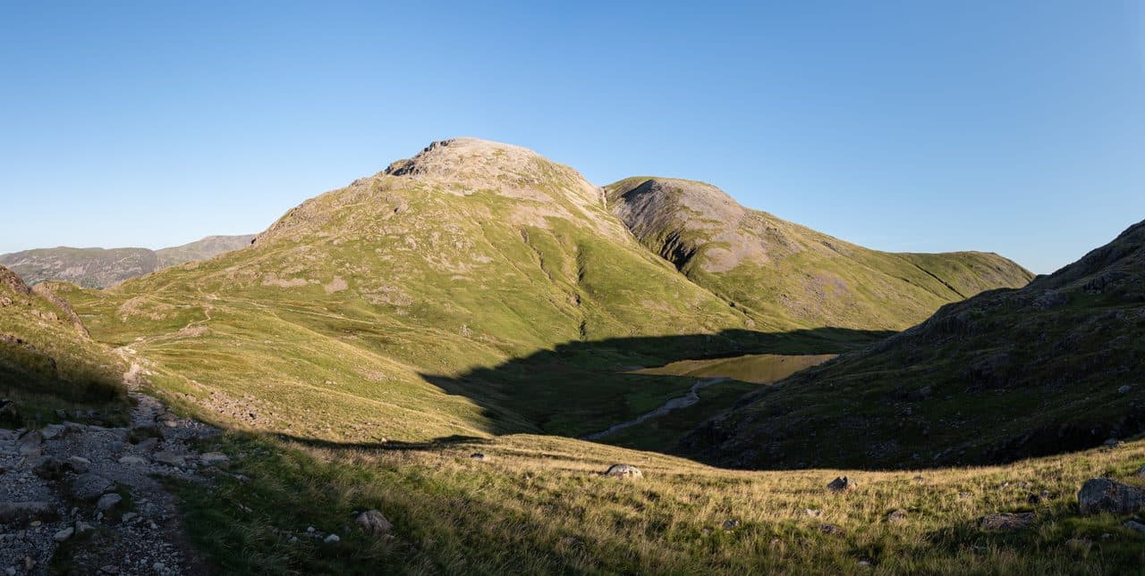
Photo: Julian Herzog via Wikimedia Commons
About Green Gable
Great Gable’s smaller sibling with a front‑row seat on the Napes. Short, punchy slopes lead to a rocky top where Ennerdale and Borrowdale compete for attention. A natural pivot on big Western Fells rounds.
Gable Crag fills the view from Green Gable, which is the best place to look at it. Seen from Ennerdale the fell has a pointed, gabled outline, but only its lower slopes are green. The summit is a desert of stones with a cairn and a wind shelter.
The top of Honister Pass is the high start. The slate mine has car parks and the seasonal 77 Honister Rambler stops there. A path contours round Grey Knotts and Brandreth, climbs to Gillercomb Head and follows a line of cairns to the summit. From Seathwaite in Borrowdale, where parking is on the roadside verge, the stone-pitched path beside Sour Milk Gill climbs into the hanging valley of Gillercomb and up past Base Brown. Another way from Seathwaite goes towards Sty Head and turns up Mitchell Cove. From Ennerdale a long walk up the valley ends with Stone Cove to Windy Gap or the easier grassy Tongue to Gillercomb Head.
None of these involves scrambling, though the path from Sour Milk Gill has a few rocky steps and the ground near the top is stony throughout. Most walkers carry on over Windy Gap to Great Gable.
Moses Trod
The contouring path from Honister also leads to Moses Trod, a high route round Great Gable to Wasdale. Local stories say Moses was a Honister quarryman who doubled as a trader and whisky smuggler, though he may never have existed.
From the summit you see up the Buttermere valley, across to Scafell Pike, and straight at the dark face of Gable Crag. Below, at the foot of Aaron Slack, lies Sty Head Tarn, about 30 feet deep.
In winter
Windy Gap, the col below Great Gable, is reached down a loose, red-stained slope that freezes hard, and Aaron Slack below it is a rough scree chute. The summit is a field of stones, and the cairned path from Honister disappears under snow.
- Great Views
- Dog Friendly
Sources: Wikipedia: Green Gable, Walk Lakes: Base Brown, Green Gable, Great Gable and Seathwaite Fell, Walk Lakes: Grey Knotts and Brandreth circular from Honister. Updated .
Summit
- OS grid ref
- NY 214 107
- Latitude
- 54.48568° N
- Longitude
- 3.21374° W
- Area
- Western Fells
Walking up Green Gable
The nearest car park on foot is Seatoller NT car park, 5.7 km (3.6 miles) from the summit along mapped paths. Directions to the car park
Route from Seatoller NT car park
- Distance
- 5.7 km
- 3.6 miles, one way
- Ascent
- 738 m
- Total climb to the summit
- Time up
- 2 h 17 min
- Allow 1 to 3 hours
Times use Naismith’s rule, 5 km/h on the flat plus extra time for the climb, with Langmuir’s corrections. It’s a rule of thumb for the way up only, so add stops, weather and the walk back down.
The route follows paths mapped by OpenStreetMap contributors and isn’t a guided line. Check the mountain forecast before you go and carry a map and compass.
Green Gable questions
Is Green Gable a Wainwright?
How high is Green Gable?
Where do you park for Green Gable?
How long does it take to climb Green Gable?
How hard is Green Gable?
Which Wainwrights are near Green Gable?
What is the grid reference for the summit of Green Gable?
Often walked with Green Gable
Fells people usually take in on the same day.
Green Gable in our guides
Wainwrights near Green Gable
Straight-line distance and direction from the summit.
 Great Gable899 m0.5 km SW
 Brandreth715 m1.2 km N
 Base Brown646 m1.3 km NE
 Seathwaite Fell601 m1.5 km E
 Grey Knotts697 m1.9 km N
 Kirk Fell802 m2.0 km W
More in the Western Fells
- Great Gable899 m
- Pillar892 m
- Scoat Fell841 m
- Red Pike [Wasdale]826 m
- Steeple819 m
- High Stile806 m
- Kirk Fell802 m
- Haycock797 m
- Red Pike [Buttermere]755 m
- High Crag744 m
- Brandreth715 m
- Caw Fell697 m
- Grey Knotts697 m
- Seatallan692 m
- Fleetwith Pike649 m
- Base Brown646 m
- Starling Dodd633 m
- Yewbarrow627 m
- Great Borne616 m
- Haystacks597 m
- Middle Fell582 m
- Blake Fell573 m
- Lank Rigg541 m
- Gavel Fell526 m
- Crag Fell523 m
- Mellbreak (south top)512 m
- Hen Comb509 m
- Grike488 m
- Burnbank Fell475 m
- Buckbarrow423 m
- Low Fell423 m
- Fellbarrow416 m
Bag Green Gable with Upfell
Reach the summit and capture Green Gable, even with no signal. It goes on your round of the 214 with its own patch.
Coming soon to theApp Store