Western Fells · Book 7
Seatallan
Seatallan is a Wainwright, one of the 214 Lake District fells in Alfred Wainwright’s Pictorial Guides. At 692 m (2,270 ft) it is the 94th highest of the 214 and the 15th highest in the Western Fells.
- Height
- 692 m
- 2,270 ft
- Rank
- 94
- of 214
- In area
- 15
- of 33
- Difficulty
- Moderate
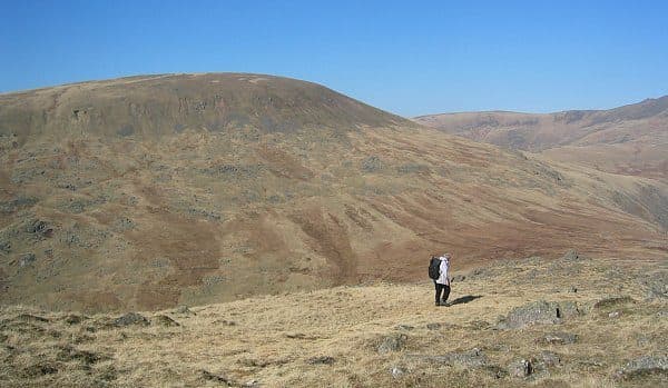
Photo: N/A
About Seatallan
A big, isolated grassy dome between Wasdale and Blengdale. Straightforward slopes lead to a large summit tumulus, though the higher Western Fells block much of the view. Usually climbed from Greendale, often with Middle Fell.
Seatallan's summit cone is an odd shape, as if sliced off at an angle, and it slopes away to the south. On top are an Ordnance Survey trig pillar, a large tumulus and a wind shelter, with a smaller cairn to the east. The view is less than you might hope. Haycock and the main ridge of the Western Fells block much of it, though Wastwater comes into sight to the north-east.
Almost every route leaves from Greendale, a few cottages on the road along the north-west shore of Wastwater. Park on the grass by the cottages (NY 144 056), less than a kilometre from the lake. One way follows Greendale Gill nearly to Greendale Tarn, then leaves it for the grass slopes above. Another uses Middle Fell as a stepping stone and crosses the marshy saddle between them. From Harrow Head the climb goes over Buckbarrow, a rampart of crag about 400 feet high, or skirts it to reach Cat Bields. There is also a line from Nether Beck Bridge that shares the Haycock path before turning west up Lad Crag Beck.
The slopes are rounded and grassy, and much of the fell is covered in glacial drift. Near the top there are boulder fields and scree beside the path, and a landslip scars the direct line from Pots of Ashness.
The favourite outing is the Greendale round. It climbs Middle Fell, crosses to Seatallan and comes back by Cat Bields, Glade How and Buckbarrow. Walk Lakes gives it as 8.5 km with about 720 m of ascent, over moderately rough ground with some wet patches.
In winter
The rounded grass slopes have few features and the higher fells hide most landmarks, so in mist the trig pillar and tumulus are the only sure marks on top. From Greendale it is a short day, which suits winter light, but the saddle over to Middle Fell is marshy underfoot.
- Great Views
- Quiet & Remote
- Dog Friendly
Sources: Wikipedia: Seatallan, Walk Lakes: Middle Fell, Seatallan, Buckbarrow, a Greendale round. Updated .
Summit
- OS grid ref
- NY 139 084
- Latitude
- 54.46366° N
- Longitude
- 3.32914° W
- Area
- Western Fells
Walking up Seatallan
The nearest car park on foot is Lake Head Car Park, 7.9 km (4.9 miles) from the summit along mapped paths. Directions to the car park
Route from Lake Head Car Park
- Distance
- 7.9 km
- 4.9 miles, one way
- Ascent
- 663 m
- Total climb to the summit
- Time up
- 2 h 37 min
- Allow 1 to 4 hours
Times use Naismith’s rule, 5 km/h on the flat plus extra time for the climb, with Langmuir’s corrections. It’s a rule of thumb for the way up only, so add stops, weather and the walk back down.
The route follows paths mapped by OpenStreetMap contributors and isn’t a guided line. Check the mountain forecast before you go and carry a map and compass.
Seatallan questions
Is Seatallan a Wainwright?
How high is Seatallan?
Where do you park for Seatallan?
How long does it take to climb Seatallan?
How hard is Seatallan?
Which Wainwrights are near Seatallan?
What is the grid reference for the summit of Seatallan?
Often walked with Seatallan
Fells people usually take in on the same day.
Seatallan in our guides
Wainwrights near Seatallan
Straight-line distance and direction from the summit.
 Middle Fell582 m1.6 km SE
 Buckbarrow423 m2.3 km S
 Haycock797 m2.4 km N
 Caw Fell697 m2.7 km N
 Yewbarrow627 m3.4 km E
 Red Pike [Wasdale]826 m3.4 km NE
More in the Western Fells
- Great Gable899 m
- Pillar892 m
- Scoat Fell841 m
- Red Pike [Wasdale]826 m
- Steeple819 m
- High Stile806 m
- Kirk Fell802 m
- Green Gable801 m
- Haycock797 m
- Red Pike [Buttermere]755 m
- High Crag744 m
- Brandreth715 m
- Caw Fell697 m
- Grey Knotts697 m
- Fleetwith Pike649 m
- Base Brown646 m
- Starling Dodd633 m
- Yewbarrow627 m
- Great Borne616 m
- Haystacks597 m
- Middle Fell582 m
- Blake Fell573 m
- Lank Rigg541 m
- Gavel Fell526 m
- Crag Fell523 m
- Mellbreak (south top)512 m
- Hen Comb509 m
- Grike488 m
- Burnbank Fell475 m
- Buckbarrow423 m
- Low Fell423 m
- Fellbarrow416 m
Bag Seatallan with Upfell
Reach the summit and capture Seatallan, even with no signal. It goes on your round of the 214 with its own patch.
Coming soon to theApp Store