Western Fells · Book 7
Fleetwith Pike
Fleetwith Pike is a Wainwright, one of the 214 Lake District fells in Alfred Wainwright’s Pictorial Guides. At 649 m (2,129 ft) it is the 116th highest of the 214 and the 16th highest in the Western Fells.
- Height
- 649 m
- 2,129 ft
- Rank
- 116
- of 214
- In area
- 16
- of 33
- Difficulty
- Difficult
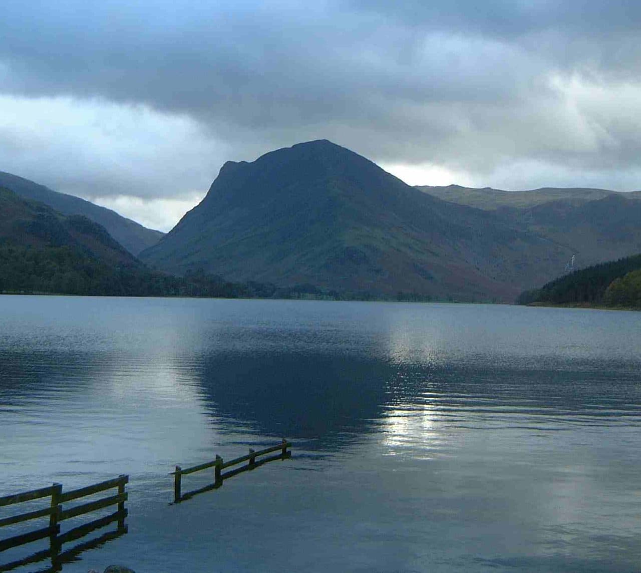
Photo: Mick Knapton via Wikimedia Commons
About Fleetwith Pike
A dramatic prow above Buttermere and the Honister road with slate scars and airy edges. Steep lines up or down give it theatre, with sunset light worth the effort. A western favourite with views that linger.
Fleetwith Edge rises almost from the shore at Gatesgarth, at the head of Buttermere, and looks intimidating from the valley. Park at Gatesgarth Farm for a small fee. Just past the last house on the Honister road, a path heads for Low Raven Crag, which looks impassable, then sneaks round its left side and zigzags up behind it. Above the crag the ridge path climbs a string of rocky steps that need your hands in places. None of it is hard, and there is usually a way round to either side if you don't stray far. A false summit at about 450 metres shows the last, steeper stretch.
The other start is the top of Honister Pass, where the slate mine has car parks and the seasonal 77 Honister Rambler bus stops. From there a route goes through the quarry workings and over Black Star, the 630 metre top of Honister Crag, and then across easy ground to the summit.
The white cross
Low Raven Crag carries a white cross, clear from the valley. Friends of Fanny Mercer put it up after she was killed in a fall on the ridge in 1887.
The summit cairn sits among grass and heather a few yards back from the top of the Edge. The view back down the valley takes in Buttermere, Crummock Water and Loweswater, with Pillar and Great Gable close at hand.
The Honister face of the fell has been quarried for green slate since the 1750s. Work stopped in 1986 and started again in 1997. A good way down passes Dubs Hut, a quarry bothy now looked after by the Mountain Bothies Association, then drops by Warnscale Beck to Warnscale Bottom and back to Gatesgarth.
In winter
Fleetwith Edge climbs through a series of rocky steps, and winter parties leave crampon scratches on them. Ice on those steps makes the edge a serious climb; the approach from Honister over Black Star is gentler and starts 356 metres up.
- Great Views
- Potentially Dangerous
Sources: Wikipedia: Fleetwith Pike, Walk Lakes: Fleetwith Pike via Fleetwith Edge, Walk Lakes: Grey Knotts and Brandreth circular from Honister. Updated .
Summit
- OS grid ref
- NY 205 141
- Latitude
- 54.51655° N
- Longitude
- 3.22816° W
- Area
- Western Fells
Walking up Fleetwith Pike
The nearest car park on foot is Gatesgarth Farm, 1.8 km (1.1 miles) from the summit along mapped paths. Directions to the car park
Route from Gatesgarth Farm
- Distance
- 1.8 km
- 1.1 miles, one way
- Ascent
- 546 m
- Total climb to the summit
- Time up
- 1 h 13 min
- Allow 1 to 2 hours
Times use Naismith’s rule, 5 km/h on the flat plus extra time for the climb, with Langmuir’s corrections. It’s a rule of thumb for the way up only, so add stops, weather and the walk back down.
The route follows paths mapped by OpenStreetMap contributors and isn’t a guided line. Check the mountain forecast before you go and carry a map and compass.
Fleetwith Pike questions
Is Fleetwith Pike a Wainwright?
How high is Fleetwith Pike?
Where do you park for Fleetwith Pike?
How long does it take to climb Fleetwith Pike?
How hard is Fleetwith Pike?
Which Wainwrights are near Fleetwith Pike?
What is the grid reference for the summit of Fleetwith Pike?
Often walked with Fleetwith Pike
Fells people usually take in on the same day.
Fleetwith Pike in our guides
Wainwrights near Fleetwith Pike
Straight-line distance and direction from the summit.
 Haystacks597 m1.6 km SW
 Grey Knotts697 m2.0 km SE
 Dale Head753 m2.1 km NE
 Brandreth715 m2.4 km SE
 Hindscarth727 m2.5 km N
 High Crag744 m2.5 km W
More in the Western Fells
- Great Gable899 m
- Pillar892 m
- Scoat Fell841 m
- Red Pike [Wasdale]826 m
- Steeple819 m
- High Stile806 m
- Kirk Fell802 m
- Green Gable801 m
- Haycock797 m
- Red Pike [Buttermere]755 m
- High Crag744 m
- Brandreth715 m
- Caw Fell697 m
- Grey Knotts697 m
- Seatallan692 m
- Base Brown646 m
- Starling Dodd633 m
- Yewbarrow627 m
- Great Borne616 m
- Haystacks597 m
- Middle Fell582 m
- Blake Fell573 m
- Lank Rigg541 m
- Gavel Fell526 m
- Crag Fell523 m
- Mellbreak (south top)512 m
- Hen Comb509 m
- Grike488 m
- Burnbank Fell475 m
- Buckbarrow423 m
- Low Fell423 m
- Fellbarrow416 m
Bag Fleetwith Pike with Upfell
Reach the summit and capture Fleetwith Pike, even with no signal. It goes on your round of the 214 with its own patch.
Coming soon to theApp Store