Western Fells · Book 7
Haycock
Haycock is a Wainwright, one of the 214 Lake District fells in Alfred Wainwright’s Pictorial Guides. At 797 m (2,615 ft) it is the 36th highest of the 214 and the 9th highest in the Western Fells.
- Height
- 797 m
- 2,615 ft
- Rank
- 36
- of 214
- In area
- 9
- of 33
- Difficulty
- Difficult
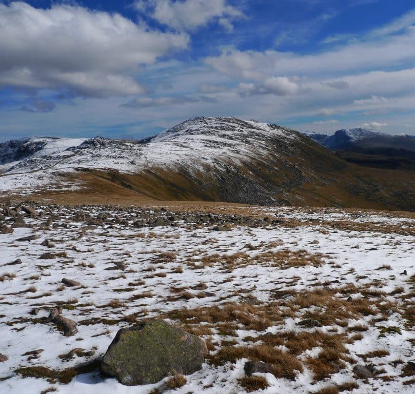
Photo: Xapbpoh via Wikimedia Commons
About Haycock
A remote, stony dome between Ennerdale and Wasdale, a long walk from either valley. Paths are narrow and the ground is rough and slow. From the top you look down on Ennerdale Water.
Haycock rises between Scoat Fell and Caw Fell on the ridge that divides Ennerdale from Wasdale. Its big stony dome is well seen from both valleys, but it is a long way from either.
From Ennerdale, park at the pay and display car park below Bowness Knott and walk the track along the lake shore. Cross Char Dub, at the head of the lake, by the Irish Bridge, then take one of the gaps through the Ling Mell plantations. The natural line up follows the spur west of Deep Gill. A longer alternative climbs the Tewit How spur and turns right at the col below Scoat Fell. Walkers often add Steeple and Scoat Fell, or carry on west along the wall to Caw Fell and come down between Silvercove Beck and Deep Gill. Such a round is about 18 km.
From Wasdale, start at Netherbeck Bridge on the Wast Water road and follow Nether Beck round the base of Middle Fell, climbing more directly once you reach Ladcrag Beck. Greendale, further down the valley, is another way in.
Paths through the heather are narrow and sometimes hard to follow, and the ground is rough and slow. There is no scrambling on these routes.
On the wall
The Ennerdale Fence, here a dry stone wall, crosses the summit with a cairn on each side. The northern cairn counts as the top. Ennerdale Water is in view from there, and Wast Water from a second cairn to the south. The Scafells stand in profile, with Helvellyn and Skiddaw far off. North west along the ridge, Little Gowder Crag shows as a rocky knuckle above Ennerdale. To the south the River Bleng rises and flows for miles through empty country to join the Irt.
In winter
Every approach is long, so daylight is the main constraint in winter. The top is broad and stony, and in cloud the Ennerdale wall running along the ridge is the handrail; stay with it between Scoat Fell and Caw Fell.
- Great Views
- Quiet & Remote
- Potentially Dangerous
- Dog Friendly
Sources: Wikipedia: Haycock, Walk Lakes: Steeple, Scoat Fell, Haycock and Caw Fell from Ennerdale, The Walking Diary: Haycock and Caw Fell. Updated .
Summit
- OS grid ref
- NY 144 107
- Latitude
- 54.48455° N
- Longitude
- 3.32155° W
- Area
- Western Fells
Walking up Haycock
The nearest car park on foot is Lake Head Car Park, 7.2 km (4.5 miles) from the summit along mapped paths. Directions to the car park
Route from Lake Head Car Park
- Distance
- 7.2 km
- 4.5 miles, one way
- Ascent
- 1041 m
- Total climb to the summit
- Time up
- 3 h 2 min
- Allow 2 to 4 hours
Times use Naismith’s rule, 5 km/h on the flat plus extra time for the climb, with Langmuir’s corrections. It’s a rule of thumb for the way up only, so add stops, weather and the walk back down.
The route follows paths mapped by OpenStreetMap contributors and isn’t a guided line. Check the mountain forecast before you go and carry a map and compass.
Haycock questions
Is Haycock a Wainwright?
How high is Haycock?
Where do you park for Haycock?
How long does it take to climb Haycock?
How hard is Haycock?
Which Wainwrights are near Haycock?
What is the grid reference for the summit of Haycock?
Often walked with Haycock
Fells people usually take in on the same day.
Haycock in our guides
Wainwrights near Haycock
Straight-line distance and direction from the summit.
 Caw Fell697 m1.3 km W
 Steeple819 m1.6 km NE
 Scoat Fell841 m1.6 km NE
 Red Pike [Wasdale]826 m2.0 km E
 Seatallan692 m2.4 km S
 Pillar892 m3.0 km NE
More in the Western Fells
- Great Gable899 m
- Pillar892 m
- Scoat Fell841 m
- Red Pike [Wasdale]826 m
- Steeple819 m
- High Stile806 m
- Kirk Fell802 m
- Green Gable801 m
- Red Pike [Buttermere]755 m
- High Crag744 m
- Brandreth715 m
- Caw Fell697 m
- Grey Knotts697 m
- Seatallan692 m
- Fleetwith Pike649 m
- Base Brown646 m
- Starling Dodd633 m
- Yewbarrow627 m
- Great Borne616 m
- Haystacks597 m
- Middle Fell582 m
- Blake Fell573 m
- Lank Rigg541 m
- Gavel Fell526 m
- Crag Fell523 m
- Mellbreak (south top)512 m
- Hen Comb509 m
- Grike488 m
- Burnbank Fell475 m
- Buckbarrow423 m
- Low Fell423 m
- Fellbarrow416 m
Bag Haycock with Upfell
Reach the summit and capture Haycock, even with no signal. It goes on your round of the 214 with its own patch.
Coming soon to theApp Store