Western Fells · Book 7
Scoat Fell
Scoat Fell is a Wainwright, one of the 214 Lake District fells in Alfred Wainwright’s Pictorial Guides. At 841 m (2,759 ft) it is the joint 22nd highest of the 214 and the 3rd highest in the Western Fells.
- Height
- 841 m
- 2,759 ft
- Rank
- =22
- of 214
- In area
- 3
- of 33
- Difficulty
- Difficult
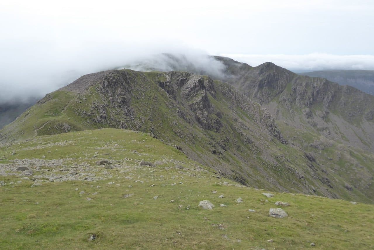
Photo: Philip Halling via Geograph, CC BY-SA 2.0
About Scoat Fell
Remote and rugged at the heart of the Mosedale Horseshoe, linking cleanly with Red Pike, Haycock and the spur of Steeple. The summit is a stony plateau with wild Ennerdale views. A long, committing round best for confident walkers.
Five ridges meet at Scoat Fell, at the head of Mosedale between Red Pike and Pillar. Most walkers reach it on the Mosedale Horseshoe from Wasdale. Park at the National Trust Lake Head car park, walk down the road to Overbeck, climb to Dore Head and go over Red Pike. Beyond Red Pike the path runs along the top of the crags above Black Comb, and for Scoat Fell you leave it and climb stony ground and boulders to the top. Other routes come up from Mosedale by Black Comb, or from Nether Beck Bridge on the Wastwater road by Scoat Tarn, a corrie pool about 20 m deep held back by grassy moraines.
From Ennerdale, start at the Bowness Knott car park (NY 109 153) and climb through the forest and over Long Crag to Steeple. A narrow, loose ridge joins Steeple to Scoat Fell. Walk Lakes' round continues to Haycock and Caw Fell, 17.9 km with 1,034 m of ascent.
The wall
The top is a long, stony plateau running east to west, and the Ennerdale Fence, a stone wall here, runs right along it. Purists built a small cairn on top of the wall to mark the highest point. The wall also means no single spot gives the whole view. Move about and you see almost the full horseshoe of the Western Fells and down into the northern coves, Mirk Cove, Mirklin Cove and Windgap Cove, with Pillar hiding part of the view.
On Ordnance Survey maps the summit is Little Scoat Fell. Great Scoat Fell is a hump at the west end, about 40 m lower despite the name. East along the ridge, Black Crag is a separate Hewitt at 828 m above the boulders of Wind Gap.
In winter
The summit plateau is broad and stony, and in mist the Ennerdale wall is the handrail between Pillar and Haycock. Mirk Cove and Mirklin Cove fall away steeply on the north side, and every route here is long against winter daylight.
- Great Views
- Quiet & Remote
- Potentially Dangerous
- Dog Friendly
Sources: Wikipedia: Scoat Fell, Walk Lakes: A Mosedale Horseshoe, Walk Lakes: Steeple, Scoat Fell, Haycock, and Caw Fell from Ennerdale. Updated .
Summit
- OS grid ref
- NY 159 113
- Latitude
- 54.49089° N
- Longitude
- 3.29920° W
- Area
- Western Fells
Walking up Scoat Fell
The nearest car park on foot is Lake Head Car Park, 5.7 km (3.6 miles) from the summit along mapped paths. Directions to the car park
Route from Lake Head Car Park
- Distance
- 5.7 km
- 3.6 miles, one way
- Ascent
- 949 m
- Total climb to the summit
- Time up
- 2 h 36 min
- Allow 1 to 4 hours
Times use Naismith’s rule, 5 km/h on the flat plus extra time for the climb, with Langmuir’s corrections. It’s a rule of thumb for the way up only, so add stops, weather and the walk back down.
The route follows paths mapped by OpenStreetMap contributors and isn’t a guided line. Check the mountain forecast before you go and carry a map and compass.
Scoat Fell questions
Is Scoat Fell a Wainwright?
How high is Scoat Fell?
Where do you park for Scoat Fell?
How long does it take to climb Scoat Fell?
How hard is Scoat Fell?
Which Wainwrights are near Scoat Fell?
What is the grid reference for the summit of Scoat Fell?
Often walked with Scoat Fell
Fells people usually take in on the same day.
Scoat Fell in our guides
Wainwrights near Scoat Fell
Straight-line distance and direction from the summit.
 Steeple819 m0.3 km NW
 Red Pike [Wasdale]826 m1.0 km SE
 Pillar892 m1.4 km NE
 Haycock797 m1.6 km SW
 Caw Fell697 m2.8 km W
 Yewbarrow627 m3.2 km SE
More in the Western Fells
- Great Gable899 m
- Pillar892 m
- Red Pike [Wasdale]826 m
- Steeple819 m
- High Stile806 m
- Kirk Fell802 m
- Green Gable801 m
- Haycock797 m
- Red Pike [Buttermere]755 m
- High Crag744 m
- Brandreth715 m
- Caw Fell697 m
- Grey Knotts697 m
- Seatallan692 m
- Fleetwith Pike649 m
- Base Brown646 m
- Starling Dodd633 m
- Yewbarrow627 m
- Great Borne616 m
- Haystacks597 m
- Middle Fell582 m
- Blake Fell573 m
- Lank Rigg541 m
- Gavel Fell526 m
- Crag Fell523 m
- Mellbreak (south top)512 m
- Hen Comb509 m
- Grike488 m
- Burnbank Fell475 m
- Buckbarrow423 m
- Low Fell423 m
- Fellbarrow416 m
Bag Scoat Fell with Upfell
Reach the summit and capture Scoat Fell, even with no signal. It goes on your round of the 214 with its own patch.
Coming soon to theApp Store