Central Fells · Book 3
Raven Crag
Raven Crag is a Wainwright, one of the 214 Lake District fells in Alfred Wainwright’s Pictorial Guides. At 461 m (1,512 ft) it is the 186th highest of the 214 and the 19th highest in the Central Fells.
- Height
- 461 m
- 1,512 ft
- Rank
- 186
- of 214
- In area
- 19
- of 27
- Difficulty
- Moderate
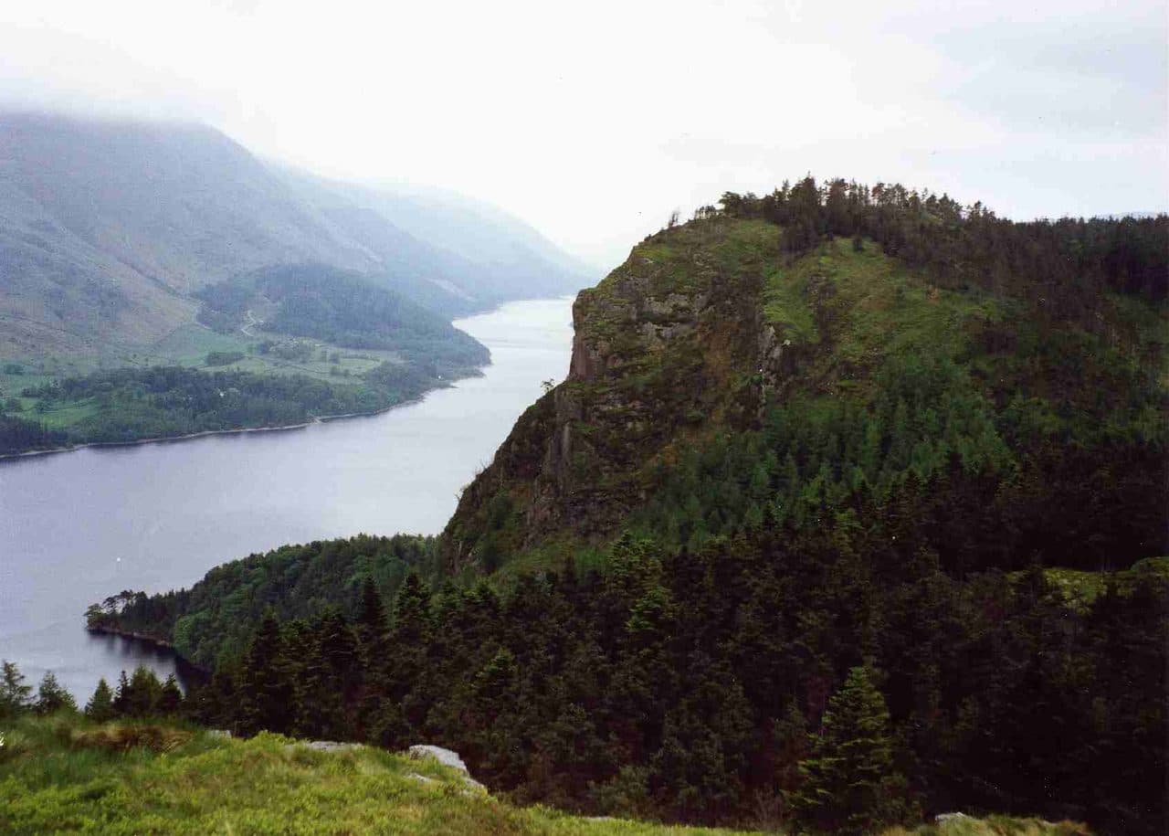
Photo: Mick Knapton via Wikimedia Commons
About Raven Crag
A dramatic Thirlmere edge with a new summit platform that punches well above its height. Forest paths and a sharp final pull lead to cliff‑edge views across to Helvellyn. A swift outing with a big‑view payoff.
Raven Crag rises out of the forest above Thirlmere dam as a sheer cliff about 150 m high. People come for the view from its edge, straight down the length of the reservoir.
There is a layby on the minor road along the west side of Thirlmere, right at the foot of the crag, with more space around the dam. You can also park on the A591 verge near Bridge End and walk across the dam wall. From the road a steep, rough, waymarked path climbs straight up through the plantation, through deer fence gates and across forestry tracks, and steps and a boardwalk take you over the last stretch to a viewing platform with a guardrail. It is short, about 2.4 km there and back with around 300 m of climbing, but the climbing starts the moment you leave the car.
The highest point is a small cairn a little way back, partly screened by conifers, so the view comes from the platform rather than the summit. From it you look down on the dam and south along Thirlmere, across to the Dodds and the Helvellyn range, with Blencathra to the north east.
Castle Crag, a rocky knoll close by on the same ridge, was the site of an Iron Age hill fort. A sign marks it, and traces of the defensive ditch and earthen bank lie under the heather and bracken. Skiddaw shows well from its top. A longer ridge walk takes in The Benn as well, and a bigger round crosses the moor south to Armboth Fell and High Tove before dropping back to the lake.
In winter
The path from the road climbs steeply through the trees, and the steps and boardwalk near the top turn slippery in frost. Stay behind the guardrail on the platform, because the east face drops sheer to the forest below.
- Great Views
- Family Walk
- Dog Friendly
Sources: Wikipedia: Raven Crag, Walk Lakes: Raven Crag and Castle Crag beside Thirlmere, Masarnen Ramblers: Raven Crag, Armboth Fell and High Tove. Updated .
Summit
- OS grid ref
- NY 303 187
- Latitude
- 54.55921° N
- Longitude
- 3.07870° W
- Area
- Central Fells
Walking up Raven Crag
The nearest car park on foot is Dam triangle car park, 1.1 km (0.7 miles) from the summit along mapped paths. Directions to the car park
Route from Dam triangle car park
- Distance
- 1.1 km
- 0.7 miles, one way
- Ascent
- 260 m
- Total climb to the summit
- Time up
- 38 min
- Allow 1 to 2 hours
Times use Naismith’s rule, 5 km/h on the flat plus extra time for the climb, with Langmuir’s corrections. It’s a rule of thumb for the way up only, so add stops, weather and the walk back down.
The route follows paths mapped by OpenStreetMap contributors and isn’t a guided line. Check the mountain forecast before you go and carry a map and compass.
Raven Crag questions
Is Raven Crag a Wainwright?
How high is Raven Crag?
Where do you park for Raven Crag?
How long does it take to climb Raven Crag?
How hard is Raven Crag?
Which Wainwrights are near Raven Crag?
What is the grid reference for the summit of Raven Crag?
Often walked with Raven Crag
Fells people usually take in on the same day.
Raven Crag in our guides
Wainwrights near Raven Crag
Straight-line distance and direction from the summit.
 High Seat608 m1.8 km SW
 Bleaberry Fell590 m2.0 km NW
 High Tove515 m2.7 km SW
 Armboth Fell475 m3.1 km S
 High Rigg357 m3.3 km N
 Watson's Dodd789 m3.3 km E
More in the Central Fells
- High Raise [Langdale]762 m
- Harrison Stickle736 m
- Sergeant Man736 m
- Ullscarf726 m
- Thunacar Knott723 m
- Pike o'Stickle708 m
- Pavey Ark700 m
- Loft Crag682 m
- High Seat608 m
- Bleaberry Fell590 m
- Sergeant's Crag571 m
- Blea Rigg556 m
- Steel Fell553 m
- Tarn Crag [Easedale]551 m
- Calf Crag537 m
- Eagle Crag525 m
- High Tove515 m
- Armboth Fell475 m
- Great Crag449 m
- Gibson Knott420 m
- Grange Fell (Brund Fell)417 m
- Helm Crag405 m
- Silver How395 m
- Walla Crag379 m
- High Rigg357 m
- Loughrigg Fell335 m
Bag Raven Crag with Upfell
Reach the summit and capture Raven Crag, even with no signal. It goes on your round of the 214 with its own patch.
Coming soon to theApp Store