Central Fells · Book 3
Harrison Stickle
Harrison Stickle is a Wainwright, one of the 214 Lake District fells in Alfred Wainwright’s Pictorial Guides. At 736 m (2,415 ft) it is the joint 69th highest of the 214 and the joint 2nd highest in the Central Fells.
- Height
- 736 m
- 2,415 ft
- Rank
- =69
- of 214
- In area
- =2
- of 27
- Difficulty
- Difficult
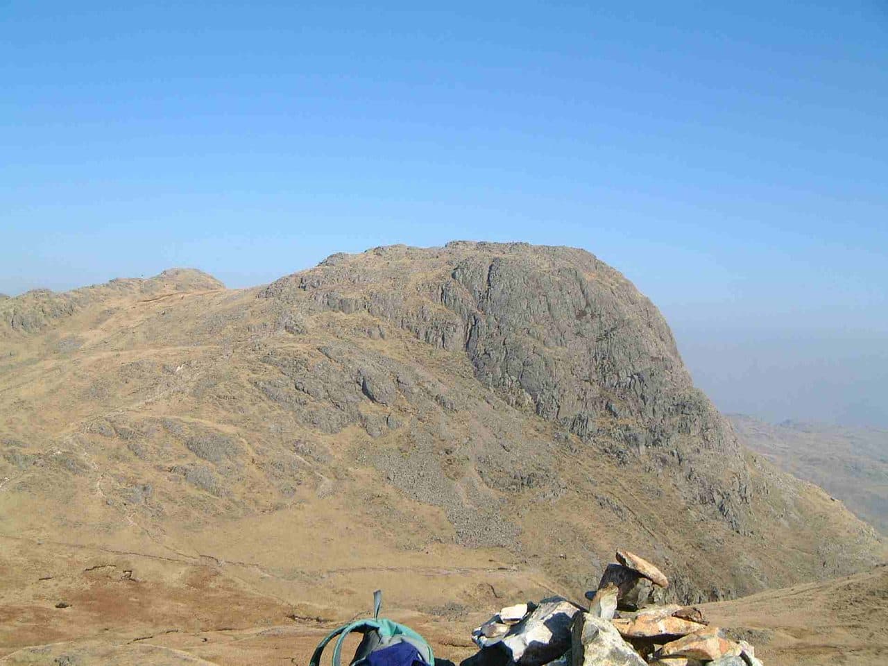
Photo: Mick Knapton via Wikimedia Commons
About Harrison Stickle
The Langdale Pikes’ dominant tooth. Short, bracing climbs from Stickle Tarn give quick access to a summit that feels bigger than its height. Texture and drama packed into a small area.
Park at the National Trust's Stickle Ghyll car park beside the New Dungeon Ghyll Hotel in Great Langdale. It is pay and display, and members park free. The 516 bus from Ambleside stops outside. The path starts behind the hotel and climbs the stone-pitched staircase beside Stickle Ghyll. It is steep and well used, with a few easy steps of scrambling where the beck squeezes between rocks.
At Stickle Tarn the crags of Pavey Ark and Harrison Stickle rise straight out of the water. The summit is above the crags, not up them. From the tarn the usual paths work round to the west of the crags and come up from behind, with cairns leading to a short scramble onto the top ridge. You can also go direct from the hotel up the south side by Pike How, which many people use as the way down. From the west, Harrison Stickle comes at the end of a round over Loft Crag and Pike o' Stickle.
The top
The summit is a short rocky ridge with a cairn at each end. The south and east faces drop about 600 metres to the valley floor, which is why the Pikes look so fierce from Langdale. On a clear day you can pick out every main group of fells.
The tarn is larger than nature made it. A dam went in during 1838 to give a steady water supply to the gunpowder works at Elterwater. The Pikes have far older industry too. Neolithic people worked the hard greenstone below the main peak into axe heads and traded them across the country. Dungeon Ghyll, a deep ravine, marks the fell's south-western boundary.
In winter
The stone-pitched path beside Stickle Ghyll holds ice and stays wet long after rain, and the short scramble onto the summit ridge is awkward under snow. The south and east faces are sheer crag, so in poor visibility come off the way you know rather than look for a shortcut.
- Great Views
- Potentially Dangerous
- Popular
- Waterfall Route
- Dog Friendly
Sources: Wikipedia: Harrison Stickle, National Trust: Stickle Tarn trail. Updated .
Summit
- OS grid ref
- NY 281 073
- Latitude
- 54.45688° N
- Longitude
- 3.10943° W
- Area
- Central Fells
Walking up Harrison Stickle
The nearest car park on foot is New Dungeon Ghyll, 2.5 km (1.6 miles) from the summit along mapped paths. Directions to the car park
Route from New Dungeon Ghyll
- Distance
- 2.5 km
- 1.6 miles, one way
- Ascent
- 648 m
- Total climb to the summit
- Time up
- 1 h 31 min
- Allow 1 to 2 hours
Times use Naismith’s rule, 5 km/h on the flat plus extra time for the climb, with Langmuir’s corrections. It’s a rule of thumb for the way up only, so add stops, weather and the walk back down.
The route follows paths mapped by OpenStreetMap contributors and isn’t a guided line. This car park was picked automatically and hasn’t been checked by hand yet, so compare it with a map. Check the mountain forecast before you go and carry a map and compass.
Harrison Stickle questions
Is Harrison Stickle a Wainwright?
How high is Harrison Stickle?
Where do you park for Harrison Stickle?
How long does it take to climb Harrison Stickle?
How hard is Harrison Stickle?
Which Wainwrights are near Harrison Stickle?
What is the grid reference for the summit of Harrison Stickle?
Often walked with Harrison Stickle
Fells people usually take in on the same day.
Harrison Stickle in our guides
Wainwrights near Harrison Stickle
Straight-line distance and direction from the summit.
 Loft Crag682 m0.5 km SW
 Pavey Ark700 m0.6 km NE
 Pike o'Stickle708 m0.8 km W
 Thunacar Knott723 m0.8 km N
 Sergeant Man736 m1.6 km N
 Blea Rigg556 m2.0 km E
More in the Central Fells
- High Raise [Langdale]762 m
- Sergeant Man736 m
- Ullscarf726 m
- Thunacar Knott723 m
- Pike o'Stickle708 m
- Pavey Ark700 m
- Loft Crag682 m
- High Seat608 m
- Bleaberry Fell590 m
- Sergeant's Crag571 m
- Blea Rigg556 m
- Steel Fell553 m
- Tarn Crag [Easedale]551 m
- Calf Crag537 m
- Eagle Crag525 m
- High Tove515 m
- Armboth Fell475 m
- Raven Crag461 m
- Great Crag449 m
- Gibson Knott420 m
- Grange Fell (Brund Fell)417 m
- Helm Crag405 m
- Silver How395 m
- Walla Crag379 m
- High Rigg357 m
- Loughrigg Fell335 m
Bag Harrison Stickle with Upfell
Reach the summit and capture Harrison Stickle, even with no signal. It goes on your round of the 214 with its own patch.
Coming soon to theApp Store