Southern Fells · Book 4
Lingmoor Fell
Lingmoor Fell is a Wainwright, one of the 214 Lake District fells in Alfred Wainwright’s Pictorial Guides. At 470 m (1,542 ft) it is the 184th highest of the 214 and the 28th highest in the Southern Fells.
- Height
- 470 m
- 1,542 ft
- Rank
- 184
- of 214
- In area
- 28
- of 30
- Difficulty
- Easy
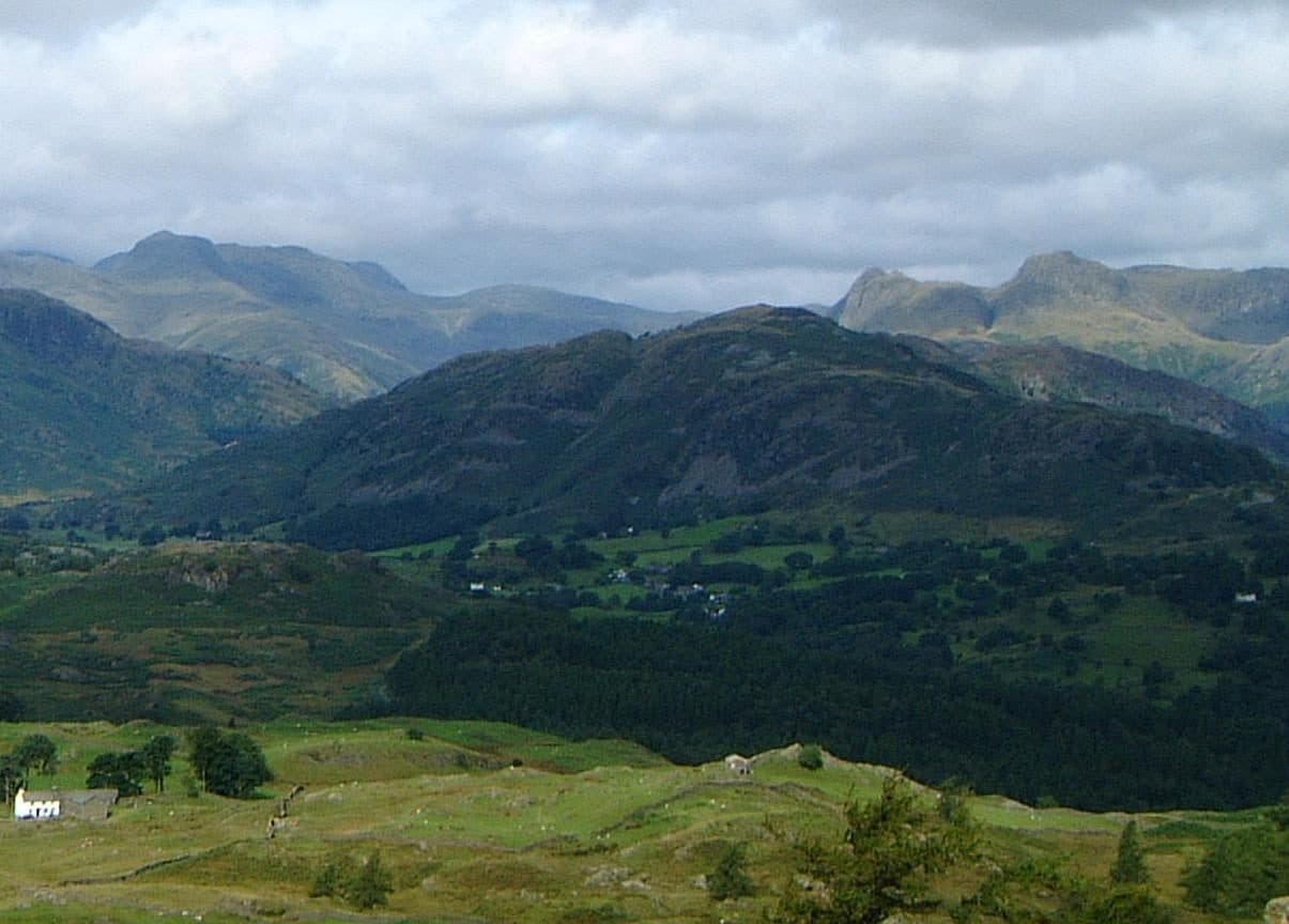
Photo: Mick Knapton via Wikimedia Commons
About Lingmoor Fell
A Southern Fells ridge dividing Great and Little Langdale. The path runs over rocky knolls with long views of the Langdale Pikes and the Coniston group. Low, but with plenty to look at.
A dry stone wall runs along the spine of Lingmoor Fell, known locally as the Great Wall of Lingmoor. It climbs from the eastern foot, stops dead at the western crags and starts again on the plateau, and you can follow it along the ridge.
From the National Trust car park at Elterwater, take the Little Langdale road, then a rough lane called the high road, past Sawrey's Wood towards Dale End Farm. A path climbs onto the open fell along an old quarry route and follows the ridge walls, past a slate seat and over a wet col. It steepens on loose scree before easy grass leads to the top, about 2.2 miles and 1,400 feet from the car park. The lower slopes above Elterwater are a tangle of paths through woods and quarries until you reach the open fell. The other start is the Blea Tarn car park in Little Langdale, where an old quarry track does most of the work and the line is simpler.
Side Pike, at the western end, is a rock tower of 362 metres. Crags block the direct way down to it from the summit, so walkers go round to easier slopes on the south.
The map names the highest point Brown How. Its cairn stands just over a fence, which you cross by a rickety stile. The Langdale Pikes, Bowfell, Crinkle Crags and the Coniston fells are all in view, with the Helvellyn range to the north-east. Lingmoor Tarn, about 650 feet long with small islands, lies 600 metres north of the summit. Above Elterwater, the Burlington slate quarry has been worked for more than 300 years and still produces green Westmorland slate.
In winter
The last pull to the top from the Elterwater side crosses loose scree below a band of low crags, which is awkward when frozen, and the col below it is wet. Side Pike can only be reached from the west and south, so in poor conditions go round it rather than trying the crags.
- Ridge Walk
- Family Walk
- Kid Friendly
- Dog Friendly
Sources: Wikipedia: Lingmoor Fell, Wainwright Routes: Lingmoor Fell Route One. Updated .
Summit
- OS grid ref
- NY 302 046
- Latitude
- 54.43205° N
- Longitude
- 3.07639° W
- Area
- Southern Fells
Walking up Lingmoor Fell
The nearest car park on foot is Blea Tarn National Trust Parking, 1.2 km (0.7 miles) from the summit along mapped paths. Directions to the car park
Route from Blea Tarn National Trust Parking
- Distance
- 1.2 km
- 0.7 miles, one way
- Ascent
- 266 m
- Total climb to the summit
- Time up
- 38 min
- Allow 1 to 2 hours
Times use Naismith’s rule, 5 km/h on the flat plus extra time for the climb, with Langmuir’s corrections. It’s a rule of thumb for the way up only, so add stops, weather and the walk back down.
The route follows paths mapped by OpenStreetMap contributors and isn’t a guided line. Check the mountain forecast before you go and carry a map and compass.
Lingmoor Fell questions
Is Lingmoor Fell a Wainwright?
How high is Lingmoor Fell?
Where do you park for Lingmoor Fell?
How long does it take to climb Lingmoor Fell?
How hard is Lingmoor Fell?
Which Wainwrights are near Lingmoor Fell?
What is the grid reference for the summit of Lingmoor Fell?
Lingmoor Fell in our guides
Wainwrights near Lingmoor Fell
Straight-line distance and direction from the summit.
 Silver How395 m3.0 km NE
 Pike o'Blisco705 m3.2 km W
 Blea Rigg556 m3.2 km N
 Harrison Stickle736 m3.5 km NW
 Loft Crag682 m3.6 km NW
 Pavey Ark700 m3.8 km NW
More in the Southern Fells
- Scafell Pike978 m
- Scafell964 m
- Great End910 m
- Bowfell903 m
- Esk Pike885 m
- Crinkle Crags (Long Top)859 m
- Lingmell807 m
- Coniston Old Man802 m
- Swirl How802 m
- Brim Fell796 m
- Allen Crags785 m
- Great Carrs785 m
- Glaramara783 m
- Dow Crag778 m
- Grey Friar773 m
- Wetherlam763 m
- Slight Side762 m
- Pike o'Blisco705 m
- Cold Pike701 m
- Harter Fell [Eskdale]654 m
- Rossett Pike651 m
- Illgill Head609 m
- Seathwaite Fell601 m
- Rosthwaite Fell (Bessyboot)551 m
- Hard Knott549 m
- Whin Rigg537 m
- Green Crag489 m
- Black Fell323 m
- Holme Fell317 m
Bag Lingmoor Fell with Upfell
Reach the summit and capture Lingmoor Fell, even with no signal. It goes on your round of the 214 with its own patch.
Coming soon to theApp Store