Southern Fells · Book 4
Great End
Great End is a Wainwright, one of the 214 Lake District fells in Alfred Wainwright’s Pictorial Guides. At 910 m (2,986 ft) it is the 5th highest of the 214 and the 3rd highest in the Southern Fells.
- Height
- 910 m
- 2,986 ft
- Rank
- 5
- of 214
- In area
- 3
- of 30
- Difficulty
- Moderate
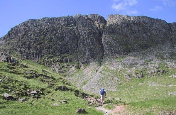
Photo: Ann Bowker
About Great End
Cliff-backed and imposing at the head of Borrowdale, Great End feels like the Scafell massif’s sentinel. Popular in winter for ice lines and in summer as a rocky, satisfying top, it is often taken en route to the higher summits beyond. Steeper final slopes and bouldery ground demand steady footwork, while the views down toward Derwentwater are superb. A memorable vantage point that punches above its height.
From Borrowdale, Great End is the dark wall of cliff at the head of the valley. Almost everyone climbs it from Seathwaite, where you park along the roadside on the lane to the farm. It is full early on fine weekends. Without a car, take the 78 Borrowdale bus to Seatoller and walk up the lane.
The usual way is south past Stockley Bridge, up Grains Gill and then Ruddy Gill, named for the red colouring in its rock, to Esk Hause. From there the top is a short detour off the main path to Scafell Pike, and many people add it on the way. You can also go up Styhead Gill, past Taylorgill Force, to Sty Head, then climb the western ridge called The Band. From Wasdale the approaches come in via Sty Head or up Lingmell Gill and Spouthead Gill. From Great Langdale you reach Esk Hause by Rossett Gill.
The upper slopes are stones and boulders, with pitched sections lower down. The walkers' routes have no exposure. The north face is another matter: its gullies are climbing routes, not paths.
There are two cairns of about the same height. The north-western one sits nearer the cliff edge and has the better outlook, straight down the length of Borrowdale to Derwentwater. Scafell Pike is a little over a mile away to the south-west. Round How, a lower top above the Corridor Route, has a small tarn called Lambfoot Dub beside it.
The gullies
The three big gullies on the north-east face are South East Gully, Central Gully and Cust's Gully. The last is named after Arthur Cust, who climbed it in winter in 1880.
In winter
The north-east cliffs get almost no sun, and their gullies hold snow well into spring. In snow or ice the north-west face is a mountaineering route, so walkers should come up from Esk Hause on the south-east side. Esk Hause itself is a confusing junction to find in mist.
- Great Views
- Popular
- Dog Friendly
Sources: Wikipedia: Great End, Walking Britain: Great End via the north west face from Seathwaite. Updated .
Summit
- OS grid ref
- NY 226 083
- Latitude
- 54.46493° N
- Longitude
- 3.19452° W
- Area
- Southern Fells
Walking up Great End
The nearest car park on foot is Lake Head Car Park, 6.1 km (3.8 miles) from the summit along mapped paths. Directions to the car park
Route from Lake Head Car Park
- Distance
- 6.1 km
- 3.8 miles, one way
- Ascent
- 974 m
- Total climb to the summit
- Time up
- 2 h 44 min
- Allow 2 to 4 hours
Times use Naismith’s rule, 5 km/h on the flat plus extra time for the climb, with Langmuir’s corrections. It’s a rule of thumb for the way up only, so add stops, weather and the walk back down.
The route follows paths mapped by OpenStreetMap contributors and isn’t a guided line. Check the mountain forecast before you go and carry a map and compass.
Great End questions
Is Great End a Wainwright?
How high is Great End?
Where do you park for Great End?
How long does it take to climb Great End?
How hard is Great End?
Which Wainwrights are near Great End?
What is the grid reference for the summit of Great End?
Often walked with Great End
Fells people usually take in on the same day.
Great End in our guides
Wainwrights near Great End
Straight-line distance and direction from the summit.
 Allen Crags785 m1.0 km E
 Esk Pike885 m1.3 km SE
 Scafell Pike978 m1.6 km SW
 Lingmell807 m1.7 km W
 Seathwaite Fell601 m1.8 km N
 Rossett Pike651 m2.4 km E
More in the Southern Fells
- Scafell Pike978 m
- Scafell964 m
- Bowfell903 m
- Esk Pike885 m
- Crinkle Crags (Long Top)859 m
- Lingmell807 m
- Coniston Old Man802 m
- Swirl How802 m
- Brim Fell796 m
- Allen Crags785 m
- Great Carrs785 m
- Glaramara783 m
- Dow Crag778 m
- Grey Friar773 m
- Wetherlam763 m
- Slight Side762 m
- Pike o'Blisco705 m
- Cold Pike701 m
- Harter Fell [Eskdale]654 m
- Rossett Pike651 m
- Illgill Head609 m
- Seathwaite Fell601 m
- Rosthwaite Fell (Bessyboot)551 m
- Hard Knott549 m
- Whin Rigg537 m
- Green Crag489 m
- Lingmoor Fell470 m
- Black Fell323 m
- Holme Fell317 m
Bag Great End with Upfell
Reach the summit and capture Great End, even with no signal. It goes on your round of the 214 with its own patch.
Coming soon to theApp Store