Southern Fells · Book 4
Pike o'Blisco
Pike o'Blisco is a Wainwright, one of the 214 Lake District fells in Alfred Wainwright’s Pictorial Guides. At 705 m (2,313 ft) it is the 86th highest of the 214 and the 18th highest in the Southern Fells.
- Height
- 705 m
- 2,313 ft
- Rank
- 86
- of 214
- In area
- 18
- of 30
- Difficulty
- Difficult
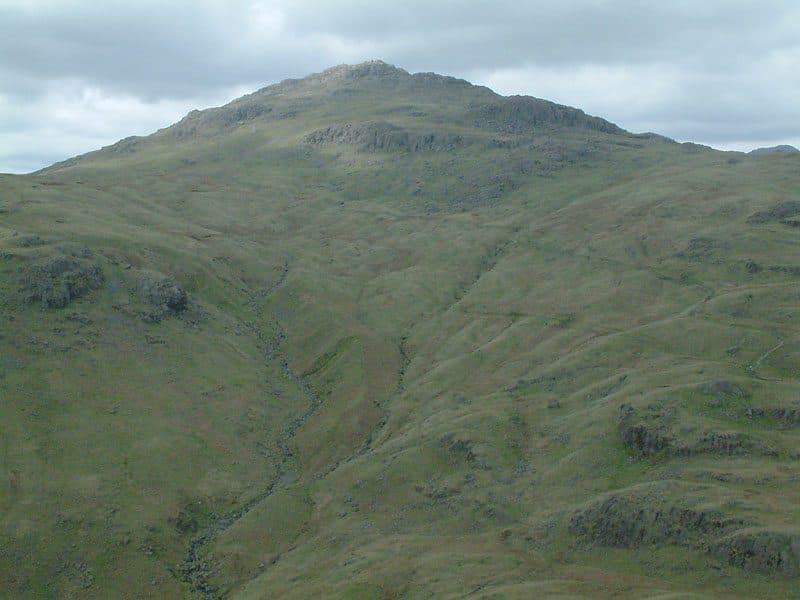
Photo: StephenDawson via Wikimedia Commons
About Pike o'Blisco
A compact mountain with a proper rocky feel right from the off. Short scrambly steps and knobbly tors give it character. Top‑tier views into Langdale and over to the Coniston fells.
Pike o'Blisco rises on its own between Great Langdale and Wrynose. Its slopes fall away on every side, so the view from the top is wide, and the best of it is across Great Langdale to the Langdale Pikes.
From the National Trust car park at the Old Dungeon Ghyll, walk the road towards Wall End and up the Blea Tarn road until a path turns off for Redacre Gill. Once over the stream, a stone-pitched path climbs a tongue of land, and cairns lead up through several rock bands that need some mild scrambling. The climb is about 2 miles with 1,950 feet of ascent. Another route leaves Stool End, crosses Oxendale Beck and goes up to Red Tarn before tackling the steep west face. The easiest start is the top of Wrynose Pass by the Three Shire Stone, where a path runs past Red Tarn. Walk Lakes makes a round from there with Cold Pike 6.5 km and 486 metres of ascent.
The ground is very rough, with boulders, scree and boggy patches on the Wrynose side. The top is split, and short rock ramps lead up to its cairns.
You can see the summit cairn from Great Langdale. A tall conical cairn stood here until it was vandalised in 1958 or 1959, and the rebuilt one is less grand. Bowfell, Crinkle Crags, Swirl How and Great Carrs fill the view, and a south top looks down on Wrynose and Red Tarn. Red Crag Mine, below Red Tarn, was worked for iron from 1860 to 1875 with little success.
In winter
The rock bands on the stone-pitched climb from Great Langdale need a little scrambling, which becomes serious in ice. The top slopes away steeply on all sides, so take care leaving the summit in mist.
- Scramble
- Great Views
- Potentially Dangerous
Sources: Wikipedia: Pike of Blisco, Wainwright Routes: Pike o'Blisco Route One, Walk Lakes: Cold Pike and Pike of Blisco. Updated .
Summit
- OS grid ref
- NY 271 042
- Latitude
- 54.42810° N
- Longitude
- 3.12490° W
- Area
- Southern Fells
Walking up Pike o'Blisco
The nearest car park on foot is Blea Tarn National Trust Parking, 2.9 km (1.8 miles) from the summit along mapped paths. Directions to the car park
Route from Blea Tarn National Trust Parking
- Distance
- 2.9 km
- 1.8 miles, one way
- Ascent
- 515 m
- Total climb to the summit
- Time up
- 1 h 22 min
- Allow 1 to 2 hours
Times use Naismith’s rule, 5 km/h on the flat plus extra time for the climb, with Langmuir’s corrections. It’s a rule of thumb for the way up only, so add stops, weather and the walk back down.
The route follows paths mapped by OpenStreetMap contributors and isn’t a guided line. This car park was picked automatically and hasn’t been checked by hand yet, so compare it with a map. Check the mountain forecast before you go and carry a map and compass.
Pike o'Blisco questions
Is Pike o'Blisco a Wainwright?
How high is Pike o'Blisco?
Where do you park for Pike o'Blisco?
How long does it take to climb Pike o'Blisco?
How hard is Pike o'Blisco?
Which Wainwrights are near Pike o'Blisco?
What is the grid reference for the summit of Pike o'Blisco?
Often walked with Pike o'Blisco
Fells people usually take in on the same day.
Pike o'Blisco in our guides
Wainwrights near Pike o'Blisco
Straight-line distance and direction from the summit.
 Cold Pike701 m1.0 km SW
 Crinkle Crags (Long Top)859 m2.3 km W
 Loft Crag682 m3.0 km N
 Pike o'Stickle708 m3.2 km N
 Lingmoor Fell470 m3.2 km E
 Great Carrs785 m3.3 km S
More in the Southern Fells
- Scafell Pike978 m
- Scafell964 m
- Great End910 m
- Bowfell903 m
- Esk Pike885 m
- Crinkle Crags (Long Top)859 m
- Lingmell807 m
- Coniston Old Man802 m
- Swirl How802 m
- Brim Fell796 m
- Allen Crags785 m
- Great Carrs785 m
- Glaramara783 m
- Dow Crag778 m
- Grey Friar773 m
- Wetherlam763 m
- Slight Side762 m
- Cold Pike701 m
- Harter Fell [Eskdale]654 m
- Rossett Pike651 m
- Illgill Head609 m
- Seathwaite Fell601 m
- Rosthwaite Fell (Bessyboot)551 m
- Hard Knott549 m
- Whin Rigg537 m
- Green Crag489 m
- Lingmoor Fell470 m
- Black Fell323 m
- Holme Fell317 m
Bag Pike o'Blisco with Upfell
Reach the summit and capture Pike o'Blisco, even with no signal. It goes on your round of the 214 with its own patch.
Coming soon to theApp Store